DMelt:ExternalGuides/VisAd
<html><head> <meta http-equiv="content-type" content="text/html; charset=windows-1252"> <title> The VisAD Java Class Library Developers Guide </title> </head> <body>
The VisAD Java Component Library
Developers Guide
7 April 2000
<a name="x"></a>
Table of Contents
1. <a href="#1.">Introduction</a>
  1.1 <a href="#1.1">System Availability</a>
  1.2 <a href="#1.2">Package Structure</a>
  1.3 <a href="#1.3">Authorship, Copyright, History and Support</a>

2. <a href="#2.">Overview</a>
  2.1 <a href="#2.1">A Very Simple Application Example</a>
  2.2 <a href="#2.2">A Simple Application Example</a>
  2.3 <a href="#2.3">Flexible Design by Reduction to Elements</a>
  2.4 <a href="#2.4">The Value of Integrated Metadata</a>
  2.5 <a href="#2.5">Toolkit for Designing Interaction Techniques</a>

3. <a href="#3.">Data Model</a>
  3.1 <a href="#3.1"> MathTypes</a>
    3.1.1 <a href="#3.1.1">RealType Constructors</a>
    3.1.2 <a href="#3.1.2">TextType Constructor</a>
    3.1.3 <a href="#3.1.3">TupleType Constructor</a>
    3.1.4 <a href="#3.1.4">RealTupleType Constructors</a>
    3.1.5 <a href="#3.1.5">FunctionType Constructor</a>
    3.1.6 <a href="#3.1.6">SetType Constructor</a>
    3.1.7 <a href="#3.1.7">MathType Methods</a>
    3.1.8 <a href="#3.1.8">ScalarType Methods</a>
    3.1.9 <a href="#3.1.9">RealType Methods</a>
    3.1.10 <a href="#3.1.10">TupleType Methods</a>
    3.1.11 <a href="#3.1.11">RealTupleType Methods</a>
    3.1.12 <a href="#3.1.12">FunctionType Methods</a>
    3.1.13 <a href="#3.1.13">SetType Methods</a>
    3.1.14 <a href="#3.1.14">Application Example: Synthesizing MathTypes</a>
    3.1.15 <a href="#3.1.15">Application Example: Analyzing MathTypes</a>
  3.2 <a href="#3.2">Data Class Hierarchy</a>
    3.2.1 <a href="#3.2.1">Real Constructors</a>
    3.2.2 <a href="#3.2.2">Text Constructor</a>
    3.2.3 <a href="#3.2.3">Tuple Constructors</a>
    3.2.4 <a href="#3.2.4">RealTuple Constructors</a>
    3.2.5 <a href="#3.2.5">Field Constructors</a>
    3.2.6 <a href="#3.2.6">Data Methods</a>
    3.2.7 <a href="#3.2.7">Real Methods</a>
    3.2.8 <a href="#3.2.8">Text Methods</a>
    3.2.9 <a href="#3.2.9">Tuple Methods</a>
    3.2.10 <a href="#3.2.10">RealTuple Methods</a>
    3.2.11 <a href="#3.2.11">Function Methods</a>
    3.2.12 <a href="#3.2.12">Field Methods</a>
    3.2.13 <a href="#3.2.13">FieldImpl Method</a>
    3.2.14 <a href="#3.2.14">Application Example: Synthesizing Fields</a>
  3.3 <a href="#3.3">Units</a>
    3.3.1 <a href="#3.3.1">Unit Methods</a>
    3.3.2 <a href="#3.3.2">SI Variables</a>
    3.3.3 <a href="#3.3.3">BaseUnit Methods</a>
    3.3.4 <a href="#3.3.4">CommonUnit Variables</a>
  3.4 <a href="#3.4">CoordinateSystems</a>
    3.4.1 <a href="#3.4.1">CoordinateSystem Constructors</a>
    3.4.2 <a href="#3.4.2">CoordinateSystem Methods</a>
  3.5 <a href="#3.5">Sets</a>
    3.5.1 <a href="#3.5.1">Defining Interpolation Algorithms by Extending the Set Class</a>
    3.5.2 <a href="#3.5.2">The Delaunay Class for Irregular Sets</a>
    3.5.3 <a href="#3.5.3">Set Constructors</a>
      3.5.3.1 <a href="#3.5.3.1">DoubleSet and FloatSet Constructors</a>
      3.5.3.2 <a href="#3.5.3.2">LinearSet Constructors</a>
      3.5.3.3 <a href="#3.5.3.3">IntegerSet Constructors</a>
      3.5.3.4 <a href="#3.5.3.4">GriddedSet Constructors</a>
      3.5.3.5 <a href="#3.5.3.5">IrregularSet Constructors</a>
      3.5.3.6 <a href="#3.5.3.6">ProductSet and UnionSet Constructors</a>
    3.5.4 <a href="#3.5.4">Set Methods</a>
    3.5.5 <a href="#3.5.5">SimpleSet Methods</a>
    3.5.6 <a href="#3.5.6">Delaunay Constructors</a>
  3.6 <a href="#3.6">ErrorEstimates</a>
    3.6.1 <a href="#3.6.1">ErrorEstimate Constructors</a>
  3.7 <a href="#3.7">AuditTrails</a>
  3.8 <a href="#3.8">Missing Data</a>
  3.9 <a href="#3.9">FlatFields - Data Operations and Efficiency</a>
    3.9.1 <a href="#3.9.1">FlatField Constructors</a>
    3.9.2 <a href="#3.9.2">FlatField Methods</a>
  3.10 <a href="#3.10">Immutable Data</a>
  3.11 <a href="#3.11">DataReferences</a>
    3.11.1 <a href="#3.11.1">DataReference Constructors</a>
    3.11.2 <a href="#3.11.2">DataReference Methods</a>
  3.12 <a href="#3.12">Application Example: Arrays versus VisAD Functions</a>
    3.12.1 <a href="#3.12.1">Subtracting Images as Pixel Arrays in C</a>
    3.12.2 <a href="#3.12.2">Subtracting Images as Pixel Arrays in VisAD</a>
    3.12.3 <a href="#3.12.3">Subtracting Images as Functions in VisAD</a>

4. <a href="#4.">Visualization</a>
  4.1 <a href="#4.1">ScalarMaps and DisplayRealTypes</a>
    4.1.1 <a href="#4.1.1">Common Sense and ScalarMaps</a>
    4.1.2 <a href="#4.1.2">DisplayRealType and DisplayTupleType Constructors</a>
    4.1.3 <a href="#4.1.3">DisplayRealType Methods Useful for Extending DataRenderer</a>
    4.1.4 <a href="#4.1.4">ScalarMap and ConstantMap Constructors</a>
    4.1.5 <a href="#4.1.5">Generally Useful ScalarMap Methods</a>
    4.1.6 <a href="#4.1.6">ScalarMap Methods Useful for Extending DataRenderer</a>
    4.1.7 <a href="#4.1.7">ConstantMap Methods</a>
    4.1.8 <a href="#4.1.8">ScalarMapListener Methods</a>
    4.1.9 <a href="#4.1.9">ScalarMapEvent Methods</a>
    4.1.10 <a href="#4.1.10">Application Example: ScalarMaps and ConstantMaps</a>
  4.2 <a href="#4.2">DataRenderers and DisplayRenderers</a>
    4.2.1 <a href="#4.2.1">Java3D DataRenderer and DisplayRenderer Constructors</a>
    4.2.2 <a href="#4.2.2">Java2D DataRenderer and DisplayRenderer Constructors</a>
    4.2.3 <a href="#4.2.3">DataRenderer Methods</a>
    4.2.4 <a href="#4.2.4">DisplayRenderer Methods</a>
    4.2.5 <a href="#4.2.5">DisplayRendererJ2D Method</a>
    4.2.6 <a href="#4.2.6">DisplayRendererJ3D Method</a>
  4.3 <a href="#4.3">Controls</a>
    4.3.1 <a href="#4.3.1">Control Methods</a>
    4.3.2 <a href="#4.3.2">ControlListener Methods</a>
    4.3.3 <a href="#4.3.3">ControlEvent Methods</a>
    4.3.4 <a href="#4.3.4">AnimationControl Methods</a>
    4.3.5 <a href="#4.3.5">ColorControl Methods</a>
    4.3.6 <a href="#4.3.6">ColorAlphaControl Methods</a>
    4.3.7 <a href="#4.3.7">ContourControl Methods</a>
    4.3.8 <a href="#4.3.8">FlowControl Methods</a>
    4.3.9 <a href="#4.3.9">GraphicsModeControl Methods</a>
    4.3.10 <a href="#4.3.10">ProjectionControl Methods</a>
    4.3.11 <a href="#4.3.11">RangeControl Methods</a>
    4.3.12 <a href="#4.3.12">ShapeControl Methods</a>
    4.3.13 <a href="#4.3.13">ValueControl Methods</a>
    4.3.14 <a href="#4.3.14">TextControl Methods</a>
  4.4 <a href="#4.4">Mouse Interactions and Direct Manipulation</a>
    4.4.1 <a href="#4.4.1">Changing Data Values by Re-drawing Data Depictions</a>
    4.4.2 <a href="#4.4.2">Application Example: Interactive Scaling</a>
  4.5 <a href="#4.5">ShadowTypes</a>
  4.6 <a href="#4.6">The Display Class</a>
    4.6.1 <a href="#4.6.1">Java3D Display Constructors</a>
    4.6.2 <a href="#4.6.2">Java2D Display Constructors</a>
    4.6.3 <a href="#4.6.3">Display Methods</a>
    4.6.4 <a href="#4.6.4">DisplayImpl Methods</a>
    4.6.5 <a href="#4.6.5">RemoteDisplayImpl Methods</a>
    4.6.6 <a href="#4.6.6">DisplayListener Methods</a>
    4.6.7 <a href="#4.6.7">DisplayEvent Methods</a>
  4.7 <a href="#4.7">Shapes</a>
    4.7.1 <a href="#4.7.1">VisADGeometryArray Shapes</a>
    4.7.2 <a href="#4.7.2">The PlotText.render_label Method</a>
  4.8 <a href="#4.8">RemoteSlaveDisplays</a>
    4.8.1 <a href="#4.8.1">RemoteSlaveDisplayImpl Constructor</a>
    4.8.2 <a href="#4.8.2">RemoteSlaveDisplayImpl Method</a>

5. <a href="#5.">Computational Cells</a>
  5.1 <a href="#5.1">Cell Constructors</a>
  5.2 <a href="#5.2">Cell Methods</a>
  5.3 <a href="#5.3">ActionImpl Methods</a>

6. <a href="#6.">Distributed Computing</a>
  6.1 <a href="#6.1">Distributed Computing Guidelines and Cautions</a>
  6.2 <a href="#6.2">Connecting to Remote Machines</a>
    6.2.1 <a href="#6.2.1">RemoteServerImpl Constructors</a>
    6.2.2 <a href="#6.2.2">RemoteServer Methods</a>
    6.2.3 <a href="#6.2.3">RemoteServerImpl Methods</a>
  6.3 <a href="#6.3">Application Example: Collaborative Direct Manipulation</a>
  6.4 <a href="#6.4">Collaborative Displays</a>

7. <a href="#7.">File Format and Data Form Adapters</a>
  7.1 <a href="#7.1">Extracting Metadata From Data Objects Returned by Data Form Adapters</a>
  7.2 <a href="#7.2">General Design of Data Form Adapters</a>
    7.2.1 <a href="#7.2.1">Form Methods</a>
  7.3 <a href="#7.3">FITS Adapter</a>
  7.4 <a href="#7.4">netCDF Adapter</a>
  7.5 <a href="#7.5">HDF-EOS Adapter</a>
  7.6 <a href="#7.6">GIF / JPEG Adapter</a>
  7.7 <a href="#7.7">Vis5D Adapter</a>
  7.8 <a href="#7.8">McIDAS Adapter</a>
  7.9 <a href="#7.9">VisAD Adapter (serialized Java objects)</a>
  7.10 <a href="#7.10">HDF-5 Adapter</a>

8. <a href="#8.">User Interfaces</a>
  8.1 <a href="#8.1">VisAD User Interface Classes</a>
    8.1.1 <a href="#8.1.1">VisADSlider Constructor</a>
    8.1.2 <a href="#8.1.2">LabeledRGBWidget and LabeledRGBAWidget Constructors</a>
    8.1.3 <a href="#8.1.3">LabeledRGBWidget and LabeledRGBAWidget Methods</a>
    8.1.4 <a href="#8.1.4">SelectRangeWidget Constructor</a>
    8.1.5 <a href="#8.1.5">AnimationWidget Constructor</a>
    8.1.6 <a href="#8.1.6">ContourWidget Constructor</a>
    8.1.7 <a href="#8.1.7">GMCWidget Constructor</a>

9. <a href="#9.">Simplified Classes for Using VisAD</a>

10. <a href="#10.">The VisAD Spread Sheet</a>
  10.1 <a href="#10.1">Spread Sheet Classes</a>
  10.2 <a href="#10.2">Features of the SpreadSheet User Interface</a>
    10.2.1 <a href="#10.2.1">Basic Commands</a>
    10.2.2 <a href="#10.2.2">Menu Commands</a>
      10.2.2.1 <a href="#10.2.2.1">File Menu</a>
      10.2.2.2 <a href="#10.2.2.2">Edit Menu</a>
      10.2.2.3 <a href="#10.2.2.3">Setup Menu</a>
      10.2.2.4 <a href="#10.2.2.4">Display Menu</a>
      10.2.2.5 <a href="#10.2.2.5">Options Menu</a>
  10.2.3 <a href="#10.2.3">Toolbars</a>
    10.2.3.1 <a href="#10.2.3.1">Main Toolbar</a>
    10.2.3.2 <a href="#10.2.3.2">Formula Toolbar</a>
      10.2.3.2.1 <a href="#10.2.3.2.1">Description</a>
      10.2.3.2.2 <a href="#10.2.3.2.2">How To Enter Formulas</a>
      10.2.3.2.3 <a href="#10.2.3.2.3">Linking to External Java Code</a>
      10.2.3.2.4 <a href="#10.2.3.2.4">Examples of Valid Formulas</a>
  10.2.4 <a href="#10.2.4">Remote Collaboration</a>
    10.2.4.1 <a href="#10.2.4.1">Creating a SpreadSheet RMI server</a>
    10.2.4.2 <a href="#10.2.4.2">Sharing individual SpreadSheet cells</a>
    10.2.4.3 <a href="#10.2.4.3">Cloning entire SpreadSheets</a>
  10.3 <a href="#10.3">Future Plans</a>

11. <a href="#11.">Extending the VisAD Java Class Library</a>

12. <a href="#12.">Application Examples</a>
  12.1 <a href="#12.1">The DisplayTest Class</a>
  12.2 <a href="#12.2">Visualizing the HSV Color CoordinateSystem</a>
  12.3 <a href="#12.3">Collaborative GOES Satellite Sounding Analysis</a>
  12.4 <a href="#12.4">A Steerable Shallow Fluid Model</a>
  12.5 <a href="#12.5">A Simple Weather Simulation Visualizer</a>
  12.6 <a href="#12.6">Image Animation Using Java2D</a>
  12.7 <a href="#12.7">Earth Topography and Bathymetry</a>

13. <a href="#13.">Caveats and Future Plans</a>
  13.1 <a href="#13.1">JavaBean Components</a>

14. <a href="#14.">For More Information and Help with Problems</a>

15. <a href="#15.">References</a>

Appendix A  <a href="#Appendix%20A">Constraints on ScalarMaps and MathTypes</a>

Appendix B  <a href="#Appendix%20B">The GoesCollaboration Application Source Code</a>
<a name="1."></a>
1. Introduction
This is the VisAD Java Component Library Developers Guide, describing the
design and use of the VisAD Java component library for interactive analysis and visualization of numerical data. It also describes the design rationale, based on lessons learned from early mainframe visualization [5], interactive visualization [6], interactive computational steering [8], high-speed networks [7, 10], virtual reality [10], and supporting a broad user community [1, 9]. Key design decisions include:
- The use of pure Java for platform independence and to support data sharing and real-time collaboration among geographically distributed users. Support for distributed computing is integrated at the lowest levels of the system.
- A general mathematical data model that can be adapted to virtually any numerical data, that supports data sharing among different users, different data sources and different scientific disciplines, and that provides transparent access to data independent of storage format and location (i.e., memory, disk or remote).
- A general display model that supports interactive 3-D, data fusion, multiple data views, direct manipulation, collaboration, and virtual reality.
- Data analysis and computation integrated with visualization to support computational steering and other complex interaction modes.
- Support for two distinct communities: developers who create domain- specific systems based on VisAD, and users of those domain-specific systems. VisAD is designed to support a wide variety of user interfaces, ranging from simple data browser applets to complex applications that allow groups of scientists to collaboratively develop data analysis algorithms.
- Developer extensibility in as many ways as possible.
<a name="1.1"></a>
1.1 System Availability
The VisAD Java class library, including complete source code and
installation instructions, is freely available from:
http://www.ssec.wisc.edu/~billh/visad.html
VisAD requires Java 1.2. VisAD displays are generated using either Java2D
(included in Java 1.2) or Java3D. More information about these is available at:
http://java.sun.com/
<a name="1.2"></a>
1.2 Package Structure
The VisAD system consists of the following packages:
  visad                        - the core VisAD package
  visad.java3d                 - Java3D displays for VisAD
  visad.java2d                 - Java2D displays for VisAD
  visad.ss                     - the VisAD Spread Sheet
  visad.formula                - formula parser
  visad.util                   - VisAD user interface utilities
  visad.data                   - VisAD data format adapters
  visad.data.fits              - VisAD - FITS file adapter
  visad.data.netcdf            - VisAD - netCDF file adapter
  visad.data.netcdf.units      - units parser for netCDF adapter
  visad.data.netcdf.in         - data input for netCDF adapter
  visad.data.netcdf.out        - data output for netCDF adapter
  visad.data.hdfeos            - VisAD - HDF-EOS file adapter
  visad.data.hdfeos.hdfeosc    - native interface to HDF-EOS
  visad.data.gif               - VisAD - GIF / JPEG file adapter
  visad.data.vis5d             - VisAD - Vis5D file adapter
  visad.data.mcidas            - VisAD - McIDAS file adapter
  visad.data.hdf5              - VisAD \96 HDF-5 file adapter
  visad.data.hdf5.hdf5objects  - helper for HDF-5 adapter
  visad.data.visad             - VisAD (serial object) file adapter
The following packages are distributed with VisAD:
  nom.tam.fits                 - Java FITS file binding
  nom.tam.util                 - Java FITS file binding
  nom.tam.test                 - Java FITS file binding
  ucar.netcdf                  - Java netCDF file binding
  ucar.multiarray              - Java netCDF file binding
  edu.wisc.ssec.mcidas         - Java McIDAS file binding
  edu.wisc.ssec.mcidas.adde    - Java McIDAS file binding
  ncsa.hdf.hdf5lib             - Java HDF-5 file binding
  ncsa.hdf.hdf5lib.exceptions  \96 Java HDF-5 file binding
  visad.paoloa                 - GOES satellite analysis
  visad.paoloa.spline          - spline fitting
  visad.aune                   - shallow fluid model
  visad.benjamin               - Milky Way galaxy model
  visad.rabin                  - rainfall estimation spread sheet
  visad.jmet                   - JMET \96 Java meteorology
  visad.bom                    - classes for ABOM
The VisAD source distribution also includes a directory visad/examples that
contains classes with the default package (i.e., no package statement).
VisAD is constantly being updated to fix bugs and add features and we don't even try to track all of these changes with VisAD version numbers. Rather, a file named 'DATE' is included in distribution jar files that gives the date and time the distribution file was created. We will change VisAD version numbers as new features accumulate.
<a name="1.3"></a>
1.3 Authorship, Copyright, History and Support
VisAD was written by programmers at the University of Wisconsin Space
Science and Engineering Center (SSEC), at the Unidata Program Office and at the National Center for Supercomputer Applications (NCSA). They are:
  Bill Hibbard - SSEC  (contact author: hibbard@facstaff.wisc.edu)
  Steve Emmerson - Unidata
  Curtis Rueden - SSEC
  Tom Rink - SSEC
  Dave Glowacki - SSEC
  Tom Whittaker - SSEC
  Tommy Jasmin - SSEC
  Don Murray - Unidata
  Nick Rasmussen - SSEC
  Peter Cao - NCSA
  James Kelly - ABOM
  Andrew Donaldson - ABOM
  Doug Lindholm - NCAR
The following people made substantial intellectual contributions to the
design:
  John Anderson - SSEC
  Dave Fulker - Unidata
  Russ Rew - Unidata
  Glen Davis - Unidata
VisAD is freely available including source code. It is protected by
copyright statements embedded in the source code and in the NOTICE, LICENSE and
COPYING files distributed with the source code.
The VisAD Java class library is actually VisAD version 2.0. VisAD versions 1.0 and 1.1 were written in C by Bill Hibbard, Brian Paul (of SSEC) and Andre Battaiola (while visiting SSEC from INPE/CPTEC in Brazil) [8, 9], with substantial intellectual contributions from Charles Dyer of the UW Computer Sciences Dept.
VisAD has adopted the UD Units library developed by Steve Emmerson of
Unidata. [1].
VisAD borrows design ideas and code from the Vis5D system for interactive
visualization of numerical simulations of weather and other environmental phenomena [6, 9, 10]. Vis5D was written in C by Bill Hibbard, Johan Kellum (of SSEC), Brian Paul, Andre Battaiola, Dave Santek (of SSEC) and Marie-Francoise
Voidrot-Martinez (while visiting SSEC from METEO France).
Vis5D grew out of the 4-D McIDAS system [5, 6], which was part of Verner
Suomi's McIDAS system for visualizing data from his weather satellites. The 4-D McIDAS was the 3-D (plus animation) analog of Tom Whittaker's 2-D graphics
subsystem of McIDAS, which was the first interactive weather graphics system.
The development of this software has been supported by NASA, EPA, NSF (via
Unidata and NCSA), NOAA, ARPA and DOE. We especially want to thank Joe Bredekamp of NASA, Cliff Jacobs of NSF and Larry Smarr of NCSA for their support of the Java VisAD. We are also grateful to the Charles and Mamie van Doren
Foundation for their support.
<a name="2."></a>
2. Overview
This is an overview of how applications are constructed using VisAD.
Throughout this guide, we will capitalize the proper names of VisAD classes such as Data and Display, in accordance with Java custom. A VisAD application is a network of:
- Data objects: these may be simple real number values, text strings, vectors of real numbers, arrays such as images or grids, or complex hierarchies of data. They may include metadata for units, coordinate systems, complex sampling topologies, missing data indicators and error estimates, or they be simple values with minimal metadata. Data objects are described more thoroughly in Section 3. Section 3.12 explains the relation between data structures in VisAD and the C programming language.
- Display objects: these generate interactive 3-D depictions of Data objects on a workstation screen or in immersive virtual reality (such as a CAVE, ImmersaDesk, or helmet). Display objects are linked to Data objects, so that Data depictions are updated whenever Data values change. Some Displays implement direct manipulation, which enables users to change Data values by re-drawing Data depictions. Displays on different machines may be linked to the same Data objects, in which case geographically distributed users may collaboratively visualize and manipulate the same Data. Displays are described more thoroughly in Section 4.
- Cell objects: these are computations that are invoked whenever their input Data objects change value. They take their name from the cells of spread sheets. Like displays, Cells are linked to Data objects through DataReference objects (in fact, Displays and Cells both extend Action, the general class for objects whose actions are triggered by changing Data values). Cell objects are described more thoroughly in Section 5.
- User interface (UI) objects: these are generally part of a UI component package such as AWT or JFC, although there are a few specialized utility UI components in the VisAD class library (described in Section 8). UI objects may also link to Data objects. Data values may be changed by UI events (for example, sliders may change the values of real number data objects), or UI components may link to Actions so that they update whenever Data object values change.
- DataReference objects: these are pointers to Data objects. For example, in the statement "x = 3", x plays the role of a DataReference object and 3 plays the role of a Data object. The value of 3 cannot change just as many VisAD Data classes have values that cannot change (these are called immutable classes). So DataReference objects are necessary to represent variable data, just as the variable "x" is necessary in programming languages. Display, Cell and UI objects are linked to Data objects through DataReference objects. And DataReference objects would be used as symbol table entries in VisAD applications that implement programming language interpreters. DataReference objects are described more thoroughly in Section 3.11.
VisAD exploits Java Remote Method Invocation (RMI) so that Data,
DataReference, Display, Cell and user interface objects may be linked together independent of their location on the network. Thus users at geographically remote workstations may collaborate by constructing Displays and linking them to the same Data object. Applications can be developed with VisAD that enable users to locate Data objects via web browsers and drag-and-drop them into Displays, link them into data analysis algorithms, and share visualizations of the results with colleagues at other locations. VisAD's use of RMI is described
more thoroughly in Section 6.
The World Wide Web has created a shared network of generally passive text and image information. Distributed objects enabled by Java RMI will make this shared network much more active; that is, a network that includes execution threads. The VisAD system's general data model and thorough use of Java RMI provide a way to build a shared, active network of scientific data, displays and computations. This network could:
- Change dynamically.
- Have many simultaneous users with their own sets of display and user interface objects.
- Have an indefinite life span, with users connecting and disconnecting but the basic network remaining.
- Support numerous interacting execution threads.
- Provide entrance points via web pages.
<a name="2.1"></a>
2.1 A Very Simple Application Example
We start with an application that reads a time sequence of images from a
netCDF file and displays it with animation. There are only four executable lines of code in the application that have anything to do with VisAD: 1) creating the netCDF file reader, 2) reading the file, 3) creating a display of the file, and 4) linking the display into a JFrame. That's about as simple as a visualization program can get. Here's the full source code:
// import needed classes
import visad.*;
import visad.util.DataUtility;
import visad.java3d.DisplayImplJ3D;
import visad.data.netcdf.Plain;
import java.rmi.RemoteException;
import java.io.IOException;
import java.awt.*;
import javax.swing.*;

public class VerySimple {

  // type 'java VerySimple' to run this application
  public static void main(String args[])
         throws VisADException, RemoteException, IOException {

    // create a netCDF reader
    Plain plain = new Plain();

    // read an image sequence from a netCDF into a data object
    DataImpl image_sequence = plain.open("images.nc");

    // create a display for the image sequence
    DisplayImpl display = DataUtility.makeSimpleDisplay(image_sequence);

    // create JFrame (i.e., a window) for the display
    JFrame frame = new JFrame("VerySimple VisAD Application");

    // link the display to the JFrame
    frame.getContentPane().add(display.getComponent());

    // set the size of the JFrame and make it visible
    frame.setSize(400, 400);
    frame.setVisible(true);
  }
}
The VerySimple.java program is included in the visad/examples directory of
the VisAD source distribution. To run it you also need to download and uncompress the images.nc file from:
ftp://www.ssec.wisc.edu/pub/visad-2.0/images.nc.Z
into your visad/examples directory.
<a name="2.2"></a>
2.2 A Simple Application Example
The VerySimple application is so simple that it hides the network of VisAD
objects it creates. Thus we present the Simple application which reads and displays the same image sequence, but provides some user interaction and makes the network of objects explicit. The diagram below shows the network of objects created by the Simple application. Its user controls a real number Data object (an hour value) via a UI slider, which in turn triggers a Cell to re-compute the value of a more complex Field Data object (for example, this may be an image
array selected from an image sequence), whose depiction is updated in a Display.
 UI slider ---> DataReference ---> Cell ---> DataReference ---> Display
                     |                            |
                     |                            |
                 Real hour                   Field image
This diagram corresponds to the following simple application code:
// import needed classes
import visad.*;
import visad.java3d.DisplayImplJ3D;
import visad.util.VisADSlider;
import visad.data.netcdf.Plain;
import java.rmi.RemoteException;
import java.io.IOException;
import java.awt.*;
import java.awt.event.*;
import java.awt.swing.*;

public class Simple {

  // type 'java Simple' to run this application
  public static void main(String args[])
         throws VisADException, RemoteException, IOException {

    // create a DataReference for an image
    final DataReference image_ref = new DataReferenceImpl("image");

    // create a netCDF reader
    Plain plain = new Plain();

    // open a netCDF file containing an image sequence and adapt
    // it to a Field Data object
    final Field image_sequence = (Field) plain.open("images.nc");

    // create a Display using Java3D
    DisplayImpl display = new DisplayImplJ3D("image display");

    // extract the type of image and use
    // it to determine how images are displayed
    FunctionType image_sequence_type =
      (FunctionType) image_sequence.getType();
    FunctionType image_type =
      (FunctionType) image_sequence_type.getRange();
    RealTupleType domain_type = image_type.getDomain();
    // map image coordinates to display coordinates
    display.addMap(new ScalarMap((RealType) domain_type.getComponent(0),
                                 Display.XAxis));
    display.addMap(new ScalarMap((RealType) domain_type.getComponent(1),
                                 Display.YAxis));
    // map image brightness values to RGB (default is grey scale)
    display.addMap(new ScalarMap((RealType) image_type.getRange(),
                                 Display.RGB));

    // link the Display to image_ref
    // display will update whenever image changes
    display.addReference(image_ref);

    // create a DataReference and RealType for an 'hour' value
    final DataReference hour_ref = new DataReferenceImpl("hour");
    RealType hour_type =
      (RealType) image_sequence_type.getDomain().getComponent(0);
    // and link it to a slider
    VisADSlider slider = new VisADSlider("hour", 0, 3, 0, 1.0,
                                         hour_ref, hour_type);

    // create a Cell to extract an image at 'hour'
    // (this is an anonymous inner class extending CellImpl)
    Cell cell = new CellImpl() {
      public void doAction() throws VisADException, RemoteException {
        // extract image from sequence by evaluating image_sequence
        // Field at 'hour' value
        image_ref.setData(image_sequence.evaluate(
                                       (Real) hour_ref.getData()));
      }
    };
    // link cell to hour_ref to trigger doAction whenever
    // 'hour' value changes
    cell.addReference(hour_ref);

    // create JFrame (i.e., a window) for display and slider
    JFrame frame = new JFrame("Simple VisAD Application");
    frame.addWindowListener(new WindowAdapter() {
      public void windowClosing(WindowEvent e) {System.exit(0);}
    });

    // create JPanel in JFrame
    JPanel panel = new JPanel();
    panel.setLayout(new BoxLayout(panel, BoxLayout.Y_AXIS));
    panel.setAlignmentY(JPanel.TOP_ALIGNMENT);
    panel.setAlignmentX(JPanel.LEFT_ALIGNMENT);
    frame.getContentPane().add(panel);

    // add slider and display to JPanel
    panel.add(slider);
    panel.add(display.getComponent());

    // set size of JFrame and make it visible
    frame.setSize(500, 600);
    frame.setVisible(true);
  }
}
Creating the DataReferences for 'hour' and 'image' and linking them to the
VisADSlider and Cell is simple. Creating the Display and linking it to the 'image' DataReference is also simple. Setting up the JFrame and JPanel are not too difficult and really independent of VisAD. The only complex part of this application is extracting the image's type information for use in setting up the Display. Every VisAD Data object has a MathType that describes its basic structure. Every real number value occurring in a complex Data object has a RealType, a subclass of MathType, that includes a name like "latitude", "time" or "temperature". The code in our simple application extracts the RealTypes from the MathType of the image so that it can define different display roles for the real number values occurring in the image. The image Data object is interpreted as a function that maps pixel locations into pixel brightnesses, and its MathType, denoted image_type, is a FunctionType that includes MathTypes for the function's domain and range. The image_type can be diagrammed as:
                       FunctionType (image_type)
                          /               \
                 function domain      function range
                 RealTupleType        RealType (brightness)
                 /           \                      |
      RealType (line)     RealType (element)        |
                  |                    |            |
                  |                    |            |
                  v                    v            v
                XAxis                YAxis         RGB
Note that the bottom of the diagram includes the scalar mappings of image_type's RealType components to DisplayRealTypes: XAxis, YAxis and RGB (RGB indicates a pseudo color lookup table that maps brightness values to red, green and blue
values).
The image_sequence Data object is treated as a function from time (hours) to images, so its MathType, denoted image_sequence_type, is also a FunctionType that can be diagrammed as:
               FunctionType (image_sequence_type)
                  /                      \
          function domain           function range
          RealType (hour)         FunctionType (image_type)
                                     /               \
                            function domain      function range
                            RealTupleType        RealType (brightness)
                            /           \
                 RealType (line)     RealType (element)
Note that the image_type diagram is replicated in the range of this
image_sequence_type diagram.
The call to the getType method of image_sequence returns its MathType, and then the calls to the getRange, getDomain and getComponent methods are used to parse the tree structure of the MathType to extract the RealTypes at the leaves of the tree. These RealTypes are then mapped to display coordinates such as Display.XAxis and Display.YAxis, and to display colors such as Display.RGB, using the ScalarMap constructors that are attached to the Display via its addMap method.
Note that image_sequence is treated as a function from a set of hour values
to a set of images, and the evaluate method of image_sequence evaluates this function at an hour value and returns an image. Thus the doAction method of our computational Cell applies the evaluate method of image_sequence to an hour value to extract an image. Note also that image_sequence is declared as a
Field, which is the VisAD class for functions represented by finite samplings.
In order to run the Simple application you need to download and uncompress
the netCDF file "images.nc" from:
ftp://www.ssec.wisc.edu/pub/visad-2.0/images.nc.Z
Response may be sluggish due to a problem with threads in early versions of Java3D. We should point out that the logic of this simple application, interactively selecting and displaying an image from an image sequence, can be implemented more simply and with faster response in a VisAD Display by mapping the "hour" RealType to Display.SelectValue. However, the Simple application is a nice illustration of how Data, DataReference, UI, Display and Cell objects can
be linked together.
Section 12.3 describes a more complex application that creates a network of linked Data, DataReference, Display, Cell and UI objects distributed around the network to support collaboration among users at geographically remote locations. This application also includes direct manipulation Displays, where users change Data values by re-drawing their depictions. Appendix B is a complete source code listing of this application.
While the application described in Section 12.3 is more complex than the one
presented here, it is still specific to a particular scientific problem. VisAD can be used to build much more flexible and generic applications. It would not be difficult to construct a generic spread sheet consisting of an array of Displays with one Data object per Display. UI components could let users add new Displays as needed and define the source of Data as: 1) a file, 2) direct manipulation in the Display, or 3) a mathematical expression involving Data objects in other Displays. VisAD could also be used as the basis for implementing a data flow system, or an interpreted numerical programming
language.
<a name="2.3"></a>
2.3 Flexible Design of Applications by Reduction to Elements
The VisAD system offers a reductionist approach to design, as illustrated in
the simple example of Section 2.2. Its image and image_sequence Data objects were defined as hierarchies of simple real values, and the Display for the image Data object was defined by mappings of its real values. This reductionist approach is very flexible in dealing with novel applications. The VisAD data model, described in Section 3, enables developers to define many different numerical data structures in terms of hierarchies built up from simple real numbers and text strings, and enables developers to attach various types of
metadata to values at different levels in the hierarchy.
The integration of metadata could allow a developer to define a sophisticated type for 2-D image data as finite samplings of continuous functions from 2-D pixel locations, such as (line, element) or (latitude, longitude), to one or more pixel radiances. Image metadata may include units for location and radiance values (e.g., radians or degrees for latitude and longitude locations), sampling topologies and geometries for pixel locations (most images have rectangular topologies, rectangular geometries in (line, element) locations but curvilinear geometries in (latitude, longitude) locations), coordinate systems for pixel locations (images with (line, element) locations may specify mathematical transformations to (latitude, longitude) locations), missing radiance indicators, and error estimates for pixel radiances and locations. Developers also have the option to ignore most of these types of metadata, and implement images as simple arrays without units, coordinate transformations, missing data or error estimates, and sampled on rectangular integer lattices (i.e., pixels are addressed by integer line and element indices, much as they are in Fortran or C arrays).
The VisAD display model offers a similar reductionist approach. Developers
define displays for complex numerical data objects in terms of mappings (the ScalarMap class) from their primitive real number elements (the RealType class) to the conceptual elements of displays (the DisplayRealType class). Developers can also attach various types of display metadata and interactive controls to these mappings. Developers may even define new kinds of display elements by
defining new DisplayRealTypes. This is described in detail in Section 4.
Designing VisAD data types and displays is similar to designing database
schemas and views. In fact, most of the differences between VisAD data types and database schemas can be traced to the fact that databases model discrete entities while numerical data are discrete approximations to continuous
entities.
VisAD's reduction to elements is very powerful for adapting to new
applications, but, like database schema design, can also be a challenge. The power comes from providing a context in which developers can answer questions like "What is the nature of an image?" However, an end user who merely wants to display an image should not have to first answer such questions. Thus VisAD user interfaces should present choices to end users in higher-level terms such as images, grids and tables. Of course, it is possible to build user interfaces for VisAD that do defer such questions to end users, in order to give them the
full power of the data model.
We also anticipate the development of intermediate class libraries between
the core VisAD system and end user interfaces, which define higher-level application-specific data classes such as images, grids and tables. The methods of these higher-level data classes can encapsulate metadata manipulation in terms of higher-level data operations, including display methods that encapsulate manipulation of ScalarMaps from RealTypes to DisplayRealTypes. Such intermediate class libraries may simplify the task for those developing user
interfaces for end users.
<a name="2.4"></a>
2.4 The Value of Integrated Metadata
The goal of integrating metadata is actually to create systems that enable
end users to ignore metadata (but also to manipulate metadata if they wish to). For example, a user might read weather model output grids from several different models and several different file formats, each sampled at different map projections, at different vertical coordinate systems and at different time steps. The file format adapters will read each file into a VisAD Data object that includes the grid data and metadata objects containing the grid's spatial and temporal sampling information. Display objects will use these metadata objects to display the grid data co-located in space and time. Furthermore, arithmetical operations will also co-locate the data. For example, if temperatures from one model are subtracted from temperatures from another model, the temperatures from the second will be resampled to the spatial and temporal locations of the first before they are subtracted. If the two models use different temperature units, these will be converted before values are
subtracted, and before they are displayed together.
Section 3.12 uses code examples to illustrate how VisAD can be used for simple array operations like those used in the C programming language, but can also be used for high-level operations on arrays of data that integrate metadata.
Users who want to control all aspects of their computations may do so by
explicitly manipulating and extending the VisAD metadata classes. Note in particular Section 3.3 on Units, 3.4 on CoordinateSystems, and Section 3.5.1 on
Defining Interpolation Algorithms by Extending the Set Class.
As the Internet enables greater data sharing among scientists, it increases
the problems associated with metadata and file format differences among scientists. Metadata integration in a common data model is an important tool for addressing these problems, both for those users who want to ignore metadata
and those who want to control metadata.
<a name="2.5"></a>
2.5 Toolkit for Designing Interaction Techniques
Interactivity is the key to understanding numerical data and computations.
This has been the driving principal behind the development of Vis5D and VisAD. The most basic interaction mode is rotating 3-D scenes, which resolves the inherent ambiguity problem of 3-D graphics. That is, while 3-D graphics are more dramatic than 2-D graphics, they suffer from the problem that every point on a 2-D display screen or on the viewer's 2-D retinas corresponds to many points in the 3-D scene. Rotating the scene, whether in response to mouse movements for workstation displays or in response to head motion in immersive
virtual reality displays, is the most effective way to resolve this ambiguity.
Once the necessary graphics speed is attained for interactive 3-D rotation, it can be exploited for all sorts of other interaction modes, such as dragging plane slices and other specialized graphics through data volumes, selecting various combinations of fields to visually compare, animating time dynamics, editing color maps, etc. VisAD supports all of these 'ordinary' graphical interaction modes when used with sufficiently fast graphics hardware.
When computations can also be done with fast response times, they may be
coupled with interactive graphics to create an interaction mode known as 'computational steering'. By allowing Data, computational Cells, Displays and user interface components to be connected flexibly, VisAD supports computational
steering interactions.
Beyond ordinary graphical interactions and computational steering, VisAD is
designed to support a number of more sophisticated graphical interaction modes. These include:
- Exploring visualization designs: experimenting with different ways to display the same data. VisAD allows users to determine how Data are depicted by defining a set of ScalarMaps from data primitives (i.e., RealTypes) to display primitives (i.e., DisplayRealTypes). Graphical user interfaces can be developed for defining ScalarMaps, enabling users to interactively experiment with display designs. For example, users might define ScalarMaps by dragging graphical icons representing RealTypes onto graphical icons representing DisplayRealTypes.
- Direct manipulation: user interaction directly with data depictions. In particular VisAD allows users to modify Data values by re-drawing their depictions. While many ordinary graphical interactions have direct manipulation interfaces, they are usually not user-definable and have simple parameterizations in terms of one or a few real numbers. VisAD allows changes to larger Data objects to be connected through computational Cells and back to graphical Displays for more complex and user-defined graphical interactions.
- Event driven computations and displays: re-computation and re-displays are triggered by data changes resulting from user interactions or running simulations. This extends the business spread sheet from simple numbers to complex numerical Data objects and their interactive 3-D visualizations. VisAD's Data, Display and Cell classes provide the tools for building numerical spread sheets.
- Remote collaboration: geographically remote users share visualizations and user interfaces as if sitting in front of the same workstation. VisAD allows multiple remote Displays to share connections to a common set of Data objects and computational Cells.
Given this variety of basic interaction modes, VisAD can be viewed as a
toolkit for building interaction techniques, in the same way that it and other systems are toolkits for building visualizations. The building blocks for interaction techniques are events, Display controls, direct manipulation, computational Cells, and shared access to Data across the network. Sections 4.4.2 and 6.3 present interesting small examples of building interaction
techniques.
<a name="3."></a>
3. Data Model
The VisAD data model was designed to support virtually any numerical data.
Rather than providing a variety of specific data structures like images, grids and tables, the VisAD data model defines a set of classes that can be used to
build any hierarchical numerical data structures.
Data objects all have a class in the class hierarchy under Data, and all define a hierarchical composition of complex Data objects from primitive Data objects. The primitive (scalar) Data classes are Real and Text. A Real object contains a real number value (i.e., a member of R, the set of all real numbers) represented by a Java double. A Text object contains a text string. Complex hierarchical Data objects are built from these primitives using the Tuple, Set and Function classes. A Tuple object contains a set of components whose number, sequence and type are fixed by the MathType of the Tuple. A Set object represents a set of points in an n-dimensional real vector space (denoted by R^n). There are a great variety of ways of representing such Sets, as described in Section 3.5. Note that a Tuple with n Real components is a RealTuple and represents a single point in R^n. A Function object represents a function from R^n to values of some specific type. Field is the subclass of Function for functions represented by finite sets of samples of function values (for example, a satellite image samples a continuous radiance function at a finite set of pixel locations). The Data classes implement methods for various binary and unary mathematical operations (e.g., add, multiply, sqrt), as well as specialized operations such as Function evaluation and Tuple component access. The Data class hierarchy is described in more detail in Section 3.2.
Data objects include metadata defined by the classes: MathType, Unit,
CoordinateSystem, Set (function domain sampling), ErrorEstimate and AuditTrail, as well as missing data indicators. The details of these different forms of metadata are described in Sections 3.1 and 3.3 - 3.8. Metadata are integrated into mathematical and visualization operations. For example Unit conversions and CoordinateSystem transforms are done implicitly as needed in Data
operations.
<a name="3.1"></a>
3.1 MathTypes
Numerical data objects are finite approximations to idealized mathematical
objects such as real numbers, vectors, sets and functions. Thus every Data object has a MathType, which indicates the type of mathematical object that it approximates. The MathType class hierarchy is:
  MathType
    ScalarType
      RealType
      TextType
    TupleType
      RealTupleType
    SetType
    FunctionType
The starting point for any new application of VisAD is defining a set of
MathTypes for the Data objects involved. This set of MathTypes provides a context for defining metadata, data displays, and data analysis operations. This is similar to the way that database schemas provide a context for defining database applications. Developers using the VisAD class library can think about MathTypes using the following shorthand syntax:
  MathType       := ScalarType | TupleType | SetType | FunctionType
  ScalarType     := RealType | TextType
  RealType       := name
  TextType       := name
  TupleType      := ( MathType , MathType , ..., MathType )
  TupleType      := RealTupleType
  RealTupleType  := ( RealType , RealType , ..., RealType )
  SetType        := set ( RealTupleType )
  FunctionType   := ( RealTupleType -> MathType )
  FunctionType   := ( RealType -> MathType )
where TupleType and RealTupleType each have at least one component. For example, a satellite image of Earth may be a finite sampling of a continuous function with MathType:
  ( (latitude, longitude) ->
    (radiance_channel_1, ..., radiance_channel_N) )
The output of a weather model may be described using the MathType:
  ( time -> ( (latitude, longitude, altitude) ->
    (temperature, pressure, dewpoint, wind_u, wind_v, wind_w) ) )
And a set of map boundaries may be described using the MathType:
set ( (latitude, longitude) )
Note that the prettyString method of MathType returns a String with this
shorthand notation for any VisAD MathType. The static stringToType method of MathType takes a String argument, which is assumed to be in this shorthand notation, and returns the corresponding MathType (of course, MathTypes returned by stringToType do not include any non-null default Units, CoordinateSystems or
Sets).
MathTypes are a form of metadata that describe data organization. For example, weather model output are often stored in files as independent 2-D grids, where any higher-level organization must be deduced by comparing the metadata associated with each grid. MathTypes provide a way to explicitly document such higher-level data organizations.
Every scalar (i.e., primitive) value occurring in a Data object is
associated with a named ScalarType occurring in the Data object's MathType. These names are used to control how the Data object is displayed, as described
in Section 4.1.
Some MathTypes include default values for various kinds of metadata,
including Units (see Section 3.3), CoordinateSystems (see Section 3.4), and samplings (see Section 3.5). Although these defaults may be over-ridden for Data values, the defaults define equivalence classes of convertible Units and CoordinateSystems among Data values with the same MathTypes, with convertibility enforced by the system. Note that application developers may opt out of Units, CoordinateSystems and any other form of metadata by setting that form of metadata to null in MathType and Data object constructors (however, developers
may not opt out of MathTypes and Field samplings, which are mandatory).
MathType is abstract and serializable. A MathType object can only be local
(see Section 6 for more information). Its subclasses are all immutable.
<a name="3.1.1"></a>
3.1.1 RealType Constructors
RealType includes the following constructors:
  /** name of type (two RealTypes are equal if their names are equal);
      default Unit for values of this type and may be null; default Set
      used when this type is a FunctionType domain and may be null */
  public RealType(String name, Unit default_unit, Set default_set)
         throws VisADException;

  /** name of type (two RealTypes are equal if their names are equal);
      default Unit and Set are null */
  public RealType(String name) throws VisADException;
<a name="3.1.2"></a>
3.1.2 TextType Constructor
TextType includes the following constructor:
  /** name of type (two TextTypes are equal if their names are equal) */
  public TextType(String name) throws VisADException;
<a name="3.1.3"></a>
3.1.3 TupleType Constructor
TupleType includes the following constructor:
  /** array of component types */
  public TupleType(MathType[] types) throws VisADException;
<a name="3.1.4"></a>
3.1.4 RealTupleType Constructors
RealTupleType includes the following constructors:
  /** array of component types;
      default CoordinateSystem for values of this type (including
      Function domains) and may be null; default Set used when this
      type is a FunctionType domain and may be null */
  public RealTupleType(RealType[] types,
                       CoordinateSystem default_coordinate_system,
                       Set default_set) throws VisADException;

  /** construct a RealTupleType with one component */
  public RealTupleType(RealType a,
                       CoordinateSystem default_coordinate_system,
                       Set default_set) throws VisADException;

  /** construct a RealTupleType with two components */
  public RealTupleType(RealType a, RealType b,
                       CoordinateSystem default_coordinate_system,
                       Set default_set) throws VisADException;

  /** construct a RealTupleType with three components */
  public RealTupleType(RealType a, RealType b, RealType c,
                       CoordinateSystem default_coordinate_system,
                       Set default_set) throws VisADException;

  /** construct a RealTupleType with four components */
  public RealTupleType(RealType a, RealType b, RealType c, RealType d,
                       CoordinateSystem default_coordinate_system,
                       Set default_set) throws VisADException;

  /** array of component types;
      default CoordinateSystem and Set are null */
  public RealTupleType(RealType[] types) throws VisADException;

  /** construct a RealTupleType with one component */
  public RealTupleType(RealType a) throws VisADException;

  /** construct a RealTupleType with two components */
  public RealTupleType(RealType a, RealType b) throws VisADException;

  /** construct a RealTupleType with three components */
  public RealTupleType(RealType a, RealType b, RealType c)
         throws VisADException;

  /** construct a RealTupleType with four components */
  public RealTupleType(RealType a, RealType b, RealType c, RealType d)
         throws VisADException;
<a name="3.1.5"></a>
3.1.5 FunctionType Constructor
FunctionType includes the following constructor:
  /** domain must be a RealType or a RealTupleType;
      range may be any MathType */
  public FunctionType(MathType domain, MathType range)
         throws VisADException;
<a name="3.1.6"></a>
3.1.6 SetType Constructor
SetType includes the following constructor:
  /** domain must be a RealType or a RealTupleType */
  public SetType(MathType domain) throws VisADException;
<a name="3.1.7"></a>
3.1.7 MathType Methods
Generally useful MathType methods include:
  /** returns a missing Data object for any MathType */
  public Data missingData() throws VisADException;

  /** return a String that indents complex MathTypes
      for human readability */
  public String prettyString();

  /** return an array of ScalarMaps that is an "intuitive"
      guess at a good way to visualize this MathType;
      returns null if it can't make a good guess */
  public ScalarMap[] guessMaps(boolean threeD);

  /** ScalarTypes are equal if they have the same name;
      TupleTypes are equal if their components are equal;
      FunctionTypes are equal if their domains and ranges
      are equal */
  public boolean equals(Object obj);

  /** this is useful for determining compatibility of
      Data objects for binary mathematical operations;
      any RealTypes are equal; any TextTypes are equal;
      TupleTypes are equal if their components are equal;
      FunctionTypes are equal if their domains and ranges
      are equal */
  public boolean equalsExceptName(MathType type);

  /** create a MathType from its string represnetation;
      essentially the inverse of the prettyString method */
  public static MathType stringToType(String s) throws VisADException;
<a name="3.1.8"></a>
3.1.8 ScalarType Methods
Generally useful ScalarType methods include:
public String getName();
<a name="3.1.9"></a>
3.1.9 RealType Methods
Generally useful RealType methods include:
  /** return any RealType constructed in this JVM with name,
      or null */
  public static RealType getRealTypeByName(String name);

  /** get default Unit */
  public Unit getDefaultUnit();

  /** get default Set*/
  public Set getDefaultSet();

  /** this is a violation of MathType immutability to allow a
      a RealType to be an argument (directly or through a
      SetType) to the constructor of its default Set;
      this method throws an Exception if getDefaultSet has
      previously been invoked */
  public void setDefaultSet(Set set) throws VisADException;
<a name="3.1.10"></a>
3.1.10 TupleType Methods
Generally useful TupleType methods include:
  /** return number of components */
  public int getDimension();

  /** return component for index between 0 and getDimension() - 1 */
  public MathType getComponent(int index) throws VisADException;

  /** return index of first component with type;
      if no such component, return -1 */
  public RealType getIndex(MathType) throws VisADException;

  /** return index of first RealType component with name;
      if no such component, return -1 */
  public RealType getIndex(String name) throws VisADException;
<a name="3.1.11"></a>
3.1.11 RealTupleType Methods
Generally useful RealTupleType methods include:
  /** get default Units of RealType components */
  public Unit[] getDefaultUnits();

  /** get default CoordinateSystem */
  public CoordinateSystem getCoordinateSystem()

  /** get default Set*/
  public Set getDefaultSet();

  /** this is an unavoidable violation of MathType immutability -
      a RealTupleType must be an argument (directly or through a
      SetType) to the constructor of its default Set;
      this method throws an Exception if getDefaultSet has
      previously been invoked */
  public void setDefaultSet(Set set) throws VisADException;
<a name="3.1.12"></a>
3.1.12 FunctionType Methods
Generally useful FunctionType methods include:
  /** if the domain passed to constructor was a RealType,
      getDomain returns a RealTupleType with that RealType
      as its single component */
  public RealTupleType getDomain();

  public MathType getRange();
<a name="3.1.13"></a>
3.1.13 SetType Methods
Generally useful SetType methods include:
  /** if the domain passed to constructor was a RealType,
      getDomain returns a RealTupleType with that RealType
      as its single component */
  public RealTupleType getDomain();
<a name="3.1.14"></a>
3.1.14 Application Example: Synthesizing MathTypes
Applications that construct Data objects from numerical values they compute
generally need to synthesize MathTypes from their RealType components. Here's a sample of code for synthesizing a MathType appropriate for a Vis5D data set (this is roughly the inverse of the code in Section 3.1.15):
  // construct RealType components for grid coordinates
  RealType row = new RealType("row", null, null);
  RealType column = new RealType("column", null, null);
  RealType level = new RealType("level", null, null);

  // construct RealTupleType for grid coordinates
  RealType[] types3d = {row, column, level};
  RealTupleType domain = new RealTupleType(types3d);

  // construct RealType components for grid fields
  RealType temperature = new RealType("temperature", null, null);
  RealType pressure = new RealType("pressure", null, null);
  RealType water_vapor = new RealType("water_vapor", null, null);

  // construct RealTupleType for grid fields
  RealType[] field3d = {temperature, pressure, water_vapor};
  RealTupleType range = new RealTupleType(field3d);

  // construct FunctionType for grid
  FunctionType grid_type = new FunctionType(domain, range);

  // construct RealType and RealTupleType for time domain
  RealType time = new RealType("time", null, null);
  RealTupleType time_type = new RealTupleType(time);

  // construct FunctionType for time sequence of grids
  FunctionType vis5d_type = new FunctionType(time_type, grid_type);
<a name="3.1.15"></a>
3.1.15 Application Example: Analyzing MathTypes
Applications that get Data objects from file format adapters (described in
Section 7) generally need to analyze MathTypes to extract their RealType components. The Vis5DForm class adapts Data objects from Vis5D files, whose MathTypes have the general form:
(time -> ((row, column, level) -> (field1, field2, ..., fieldN)))
That is, they are time sequences of multivariate 3-D grids. Here's a sample of MathType analysis code (this is roughly the inverse of the code in Section 3.1.14):
  // get the MathType of a Data object named 'vis5d'
  FunctionType vis5d_type = (FunctionType) vis5d.getType();

  // extract time, the domain of the FunctionType
  RealType time = (RealType) vis5d_type.getDomain().getComponent(0);

  // get grid_type, itself a FunctionType and the range of the
  // vis5d_type FunctionType
  FunctionType grid_type = (FunctionType) vis5d_type.getRange();

  // get the grid domain RealTupleType
  RealTupleType domain = grid_type.getDomain();

  // get the grid domain component RealType - they are grid coordinates
  RealType row = (RealType) domain.getComponent(0);
  RealType column = (RealType) domain.getComponent(1);
  RealType level = (RealType) domain.getComponent(2);

  // get the grid range - it is a RealTupleType of fields
  RealTupleType range = (RealTupleType) grid_type.getRange();

  // get the number of grid range components
  int dim = range.getDimension();

  // construct an array to hold the grid range RealTypes
  RealType[] range_types = new RealType[dim];

  // get the grid range RealTypes
  for (int i=0; i<dim; i++) {
    range_types[i] = (RealType) range.getComponent(i);
  }
<a name="3.2"></a>
3.2 Data Class Hierarchy
The Data hierarchy is:
  Data
    Scalar
      Real
      Text
    Tuple
      RealTuple
    Set
      (there is a large hierarchy under Set as described in Section 3.5)
    Function
      Field
        FlatField
To some extent the Data hierarchy mirrors the MathType hierarchy. However,
it is important to note that MathType is not a synonym for Data class, since Data classes may be elaborated into different forms of finite representation of the corresponding MathTypes. For example, Set is elaborated into a large number of different ways of representing subsets of R^n. Similarly, Function is elaborated into Field, for functions represented by finite samplings, and FlatField, for Fields with simple range values that can be represented by small numbers of Java's primitive data types rather than by objects. Developers may extend the Data classes to define new forms of representation. For example, a developer could extend Real to define a representation by ratios of infinite- precision integers rather than the Java primitive double used by Real (doubles are used by Real because experience has shown that using floats as the default can cause round-off problems that are extremely difficult for application
developers to detect and diagnose).
The Data hierarchy is also elaborated for various data storage locations and formats. Section 6 describes how the hierarchy for Data and other VisAD classes is structured for local and remote objects, and Section 7 describes how the Data class hierarchy is adapted to import data from various file formats. The Data hierarchy is being adapted to netCDF, HDF and FITS files, and developers may extend this to other file formats. Thus data are accessible via the VisAD Data API (Application Programming Interface) independent of storage location, file format and approximating representation.
The metadata classes described in Sections 3.1 and 3.3 - 3.8 define how Data
objects approximate mathematical objects and how they model the world.
Data is an interface that may apply to both local and remote Data objects.
DataImpl is an abstract class that only applies to local Data objects, and RemoteData is an interface that only applies to remote Data objects (see Section 6 for more information). DataImpl is cloneable and serializable. All of its subclasses except FieldImpl and FlatField are immutable. API documentation for the Set class hierarchy is described in Section 3.5 and for FlatFields is
described in Section 3.9, rather than here.
<a name="3.2.1"></a>
3.2.1 Real Constructors
Real includes the following constructors:
  /** unit and error may be null */
  public Real(RealType type, double value, Unit unit,
              ErrorEstimate error) throws VisADException;

  /** use RealType.Generic */
  public Real(double value)
<a name="3.2.2"></a>
3.2.2 Text Constructor
Text includes the following constructor:
  public Text(TextType type, String value) throws VisADException;

  /** use TextType.Generic */
  public Text(String value)
<a name="3.2.3"></a>
3.2.3 Tuple Constructors
Tuple includes the following constructors:
  /** this constructs its MathType from the MathTypes of the
      data array; components are copies of data */
  public Tuple(Data[] data) throws VisADException, RemoteException;

  /** only copy data if copy == true */
  public Tuple(Data[] data, boolean copy)
         throws VisADException, RemoteException;
<a name="3.2.4"></a>
3.2.4 RealTuple Constructors
RealTuple includes the following constructors:
  /** coordinate_system may be null; otherwise
      coordinate_system.getReference() must equal
      type.getCoordinateSystem.getReference() */
  public RealTuple(RealTupleType type, Real[] reals,
                   CoordinateSystem coordinate_system)
         throws VisADException, RemoteException;

  public RealTuple(Real[] reals) throws VisADException, RemoteException;
<a name="3.2.5"></a>
3.2.5 Field Constructors
Field is an interface implemented by FieldImpl for local Fields and
RemoteFieldImpl for remote Fields. See Section 6 for more information about distributed computing. These classes have the following constructors:
  /** FieldImpl is the most general sampled function;
      domain_set defines the domain sampling;
      if it is null, use the default Set of type.getDomain();
      domain_set defines the Units and CoordinateSystem
      of the Field domain */
  public FieldImpl(FunctionType type, Set domain_set)
         throws VisADException;

  /** use the default Set of type.getDomain() */
  public FieldImpl(FunctionType type) throws VisADException;

  /** construct a RemoteFieldImpl object to provide remote
      access to field */
  public RemoteFieldImpl(FieldImpl field)
         throws VisADException, RemoteException;
<a name="3.2.6"></a>
3.2.6 Data Methods
A Data object may be either local or remote, a DataImpl object may only be
local and a RemoteData object may only be remote (see Section 6 for more information). The methods in this section define the universal operations applicable to all Data objects: getType returns a Data object's MathType, isMissing indicates whether the Data object has missing value (but note that even is a Data object is not missing, it may still have sub-objects with missing
values), and local replaces a RemoteData object with a local DataImpl copy.
The binary and unary methods define basic mathematical operations on Data that are the building blocks for data analysis using VisAD. The binary and unary methods have wrapper methods for specific operations like add and sin. These operations are defined point-by-point for Tuple and Function Data objects, so that for example, the sin of a Function is a Function whose values are the sines of the original Function's values.
When add (or any other binary operation) is applied to two Fields the result
is a Field whose values are the sums (or other operation) of the values of the two Functions, but only if the MathTypes of the two Fields match. MathType matching is defined recursively on TupleTypes and FunctionTypes in terms of their components, any RealType matches any RealType, and any TextType matches any TextType (thus matching Functions must have domains with the same
dimension).
Most important, binary and unary operations on Data objects involve their
metadata. When two Fields are added, the domain samples of one are resampled to the domain samples of the other, including any necessary Unit conversions of Real components of the domains and any necessary CoordinateSystem transformations between RealTuple domains. The range values of one Field are estimated at the domain sample locations of the other Field using either nearest neighbor or weighted average algorithms, as specified in the optional resampling_mode argument to binary methods. Unit conversions and CoordinateSystem transformations are also applied as needed to range values of Fields before they are added. Furthermore, ErrorEstimates attached to Field range values are modified to reflect error effects of binary and unary operations. ErrorEstimate propagation may assume either that operand errors are independently or dependently distributed, or ErrorEstimate propagation may be
disabled, using the error_mode argument to binary and unary methods.
In some cases Data objects may be combined in binary operations even if
their MathTypes do not match. For example, a Real object may be combined with any other Data object, and a Functions may be combined with Data objects that match the MathType of the Function's range.
  public MathType getType()
         throws VisADException, RemoteException;

  /** flag indicating whether Data object has missing value */
  public boolean isMissing()
         throws VisADException, RemoteException;

  /** if remote, return a local copy;
      if local, return this */
  public DataImpl local()
         throws VisADException, RemoteException;

  /** general binary operation between this and data; operation may
      be Data.ADD, Data.SUBTRACT, etc; these include all binary
      operations defined for Java primitive data types; new_type
      is the MathType of the result; sampling_mode may be
      Data.NEAREST_NEIGHBOR or Data.WEIGHTED_AVERAGE; error_mode
      may be Data.INDEPENDENT, Data.DEPENDENT or Data.NO_ERRORS */
  public Data binary(Data data, int operation, MathType new_type,
                     int sampling_mode, int error_mode)
         throws VisADException, RemoteException;

  /** like previous signature of binary, except the result takes
      the MathType of this unless the default Units of that MathType
      conflict with Units of the result, in which case a generic
      MathType with appropriate Units is constructed */
  public Data binary(Data data, int operation, int sampling_mode,
                     int error_mode)
         throws VisADException, RemoteException;

  public Data add(Data data, int sampling_mode, int error_mode)
         throws VisADException, RemoteException;

  /** use Data.NEAREST_NEIGHBOR and Data.NO_ERRORS */
  public Data add(Data data) throws VisADException, RemoteException;

  public Data subtract(Data data, int sampling_mode, int error_mode)
         throws VisADException, RemoteException;

  /** use Data.NEAREST_NEIGHBOR and Data.NO_ERRORS */
  public Data subtract(Data data) throws VisADException, RemoteException;

  /** similar methods are defined for the following binary operators:
      multiply, divide, pow, max, min, atan2, atan2Degrees and
      remainder */

  /** general unary operation; operation may be Data.ABS, Data.ACOS, etc;
      these include all unary operations defined for Java primitive data
      types; new_type is the MathType of the result; sampling_mode may be
      Data.NEAREST_NEIGHBOR or Data.WEIGHTED_AVERAGE; error_mode may be
      Data.INDEPENDENT, Data.DEPENDENT or Data.NO_ERRORS */
  public Data unary(int operation, MathType new_type, int sampling_mode,
                    int error_mode)
         throws VisADException, RemoteException;

  /** like previous signature of unary, except the result takes
      the MathType of this unless the default Units of that MathType
      conflict with Units of the result, in which case a generic
      MathType with appropriate Units is constructed */
  public Data unary(int operation, int sampling_mode, int error_mode)
         throws VisADException, RemoteException;

  /** clone this Data object except give it new_type */
  public Data changeMathType(MathType new_type)
         throws VisADException, RemoteException;

  public Data abs(int sampling_mode, int error_mode)
         throws VisADException, RemoteException;

  /** use Data.NEAREST_NEIGHBOR and Data.NO_ERRORS */
  public Data abs() throws VisADException, RemoteException;

  public Data acos(int sampling_mode, int error_mode)
         throws VisADException, RemoteException;

  /** use Data.NEAREST_NEIGHBOR and Data.NO_ERRORS */
  public Data acos() throws VisADException, RemoteException;

  /** similar methods are defined for the following unary operators:
      acosDegrees, asin, asinDegrees, atan, atanDegrees, ceil, cos,
      cosDegrees, exp, floor, log, rint, round, sin, sinDegrees,
      sqrt, tan, tanDegrees, negate */
<a name="3.2.7"></a>
3.2.7 Real Methods
A Real object may only be local. Binary operations may be performed between
a Real and any other Data object that does not contain Text components; such operations are applied independently with each Real component. Generally useful Real methods include:
  public final double getValue();

  /** get double value converted to unit */
  public final double getValue(Unit unit) throws VisADException;

  public Unit getUnit();

  public ErrorEstimate getError();
<a name="3.2.8"></a>
3.2.8 Text Methods
Text may only be local. The only binary operation that works for Text is
Data.ADD, which is interpreted as string concatenation. No unary operations work for Text. Generally useful Text methods include:
public String getValue();
<a name="3.2.9"></a>
3.2.9 Tuple Methods
A Tuple object may only be local. Generally useful Tuple methods include:
  /** return number of components */
  public int getDimension();

  /** return component for index between 0 and getDimension() - 1 */
  public MathType getComponent(int index) throws VisADException;

  /** construct Tuple; used for constructing Tuples in Spreadsheet;
      e.g., link(visad.Tuple.makeTuple(A2, B1, B2)) */
  public static Tuple makeTuple(Data[] datums)
         throws VisADException, RemoteException
<a name="3.2.10"></a>
3.2.10 RealTuple Methods
A RealTuple object may only be local. Generally useful RealTuple methods
include:
  /** get Units of Real components */
  public Unit[] getTupleUnits();

  /** get ErrorEstimates of Real components */
  public ErrorEstimate[] getErrors() throws VisADException;

  /** get CoordinateSystem */
  public CoordinateSystem getCoordinateSystem();
<a name="3.2.11"></a>
3.2.11 Function Methods
A Function object may be either local or remote, a FunctionImpl object may
only be local and a RemoteFunction object may only be remote (see Section 6 for more information). Generally useful Function methods are listed below. Note in particular the resample method which is invoked implicitly for many visualization and mathematical operations on Functions and can be invoked by
applications for image remapping and a variety of similar Function operations.
  /** get dimension of Function domain */
  public int getDomainDimension()
         throws VisADException, RemoteException;

  /** get Units of domain Real components */
  public Unit[] getDomainUnits()
         throws VisADException, RemoteException;

  /** get domain CoordinateSystem */
  public CoordinateSystem getDomainCoordinateSystem()
         throws VisADException, RemoteException;

  /** evaluate Function at domain_value, for 1-D domains */
  public Data evaluate(Real domain_value, int sampling_mode,
                       int error_mode)
         throws VisADException, RemoteException;

  /** evaluate Function at domain_value, for 1-D domains,
      using Data.NEAREST_NEIGHBOR and Data.NO_ERRORS */
  public Data evaluate(Real domain_value)
         throws VisADException, RemoteException;

  /** evaluate Function at domain_value */
  public Data evaluate(RealTuple domain_value, int sampling_mode,
                       int error_mode)
         throws VisADException, RemoteException;

  /** evaluate Function at domain_value using
      Data.NEAREST_NEIGHBOR and Data.NO_ERRORS */
  public Data evaluate(RealTuple domain_value)
         throws VisADException, RemoteException;

  /** return a Field of Function values at samples in set;
      this combines unit conversions, coordinate transforms,
      resampling and interpolation */
  public Field resample(Set set, int sampling_mode, int error_mode)
         throws VisADException, RemoteException;

  /** return the derivative of this Function with respect to d_partial;
      d_partial may occur in this Function's domain RealTupleType, or,
      if the domain has a CoordinateSystem, in its Reference
      RealTupleType; propogate errors according to error_mode */
  public abstract Function derivative(RealType d_partial,
         int error_mode) throws VisADException, RemoteException;

  /** return the derivative of this Function with respect to d_partial;
      set result MathType to derivType; d_partial may occur in this
      Function's domain RealTupleType, or, if the domain has a
      CoordinateSystem, in its Reference RealTupleType;
      propogate errors according to error_mode */
  public abstract Function derivative(RealType d_partial,
         MathType derivType, int error_mode)
         throws VisADException, RemoteException;

  /** return the tuple of derivatives of this Function with respect to
      all RealType components of its domain RealTupleType;
      propogate errors according to error_mode */
  public abstract Data derivative(int error_mode)
         throws VisADException, RemoteException;

  /** return the tuple of derivatives of this Function with respect
      to all RealType components of its domain RealTupleType;
      set result MathTypes of tuple components to derivType_s;
      propogate errors according to error_mode */
  public abstract Data derivative(MathType[] derivType_s,
         int error_mode) throws VisADException, RemoteException;

  /** return the tuple of derivatives of this Function with respect
      to the RealTypes in d_partial_s; the RealTypes in d_partial_s
      may occur in this Function's domain RealTupleType, or, if the
      domain has a CoordinateSystem, in its Reference RealTupleType;
      set result MathTypes of tuple components to derivType_s;
      propogate errors according to error_mode */
  public abstract Data derivative(RealTuple location,
         RealType[] d_partial_s, MathType[] derivType_s, int error_mode)
         throws VisADException, RemoteException;
<a name="3.2.12"></a>
3.2.12 Field Methods
A Field object may be either local or remote, a FieldImpl object may only
be local and a RemoteField object may only be remote (see Section 6 for more information). Generally useful Field methods include:
  /** set the values of the Field (at the domain Set samples)
      using the values in range (the length of range must
      equal the length of the domain Set);
      make copies of range values if copy is true */
  public void setSamples(Data[] range, boolean copy)
         throws VisADException, RemoteException;

  /** get the domain Set */
  public Set getDomainSet()
         throws VisADException, RemoteException;

  /** get the Units of the Real components of the domain Set */
  public Unit[] getDomainUnits()
         throws VisADException, RemoteException;

  /** get the CoordinateSystem of the domain Set */
  public CoordinateSystem getDomainCoordinateSystem()
         throws VisADException, RemoteException;

  /** get the Field value at the index-th sample in the
      domain Set */
  public Data getSample(int index)
         throws VisADException, RemoteException;

  /** get the 'Flat' components of this Field's range values
      in their default range Units (as defined by the range of
      the Field's FunctionType); if the range type is a RealType
      it is a 'Flat' component, if the range type is a TupleType
      its RealType components and RealType components of its
      RealTupleType components are all 'Flat' components; the
      return array is dimensioned:
      double[number_of_flat_components][number_of_range_samples] */
  public double[][] getValues()
         throws VisADException, RemoteException;

  /** set Field value at the index-th sample in the
      domain Set, to range */
  public void setSample(int index, Data range)
         throws VisADException, RemoteException;

  /** set Field value at the sample in the domain Set nearest
       domain, to range */
  public void setSample(RealTuple domain, Data range)
         throws VisADException, RemoteException;

  /** return an Enumeration of RealTuple values in domain Set */
  public Enumeration domainEnumeration()
         throws VisADException, RemoteException;

  /** return true is this is a FlatField */
  public boolean isFlatField();

  /** assumes the range type of this is a Tuple and returns
      a Field with the same domain as this, but whose range
      samples consist of the specified Tuple component of the
      range samples of this; in shorthand, this[].component */
  public Field extract(int component)
         throws VisADException, RemoteException;

  /** combine domains of two outpost nested Fields into a single
      domain and Field; for examples transform the MathType
      (a -> ((b, c) -> d)) into ((a, b, c) -> d) */
  public Field domainMultiply()
         throws VisADException, RemoteException;

  /** factor Field domain into domains of two nested Fields (with
      factor as outer domain); for examples transform the MathType
      ((a, b, c) -> d) into (a -> ((b, c) -> d)) (where factor = a) */
  public Field domainFactor(RealType factor)
         throws VisADException, RemoteException;
<a name="3.2.13"></a>
3.2.13 FieldImpl Method
This describes a single static method of FieldImpl:
  /** resample all elements of the fields array to the domain
      set of fields[0], then return a Field whose range samples
      are Tuples merging the corresponding range samples from
      each element of fields; if the range of fields[i] is a
      Tuple without a RangeCoordinateSystem, then each Tuple
      component of a range sample of fields[i] becomes a
      Tuple component of a range sample of the result -
      otherwise a range sample of fields[i] becomes a Tuple
      component of a range sample of the result; this assumes
      all elements of the fields array have the same domain
      dimension */
  public static Field combine(Field[] fields)
         throws VisADException, RemoteException;
<a name="3.2.14"></a>
3.2.14 Application Example: Synthesizing Fields
In this example we assume that:
  grid_type =
    ((row, column, level) -> (temperature, pressure, water_vapor))
and:
vis5d_type = (time -> grid_type)
These are the types appropriate for Vis5D data sets synthesized by the example in Section 3.1.14. This example includes constructors for an Integer3DSet and an Integer1DSet, which are described in detail in Section 3.5.3.3, and a constructor for a FlatField, which is an efficient sub-class of FieldImpl described in Section 3.9. The Integer3DSet is an integer lattice of 50 by 50 by 20 points for a Vis5D grid, and the Integer1DSet is a sequence of hour values from 0 to 23. FlatField includes a version of the setSamples method that takes an array of floats, in addition to the version of setSamples inherited from FieldImpl that takes an array of Data objects. Here's a sample of code for synthesizing a FieldImpl appropriate for a Vis5D data set:
  // construct an integer 3-D grid
  Set grid_set = new Integer3DSet(50, 50, 20);

  // construct a sequence of 24 hours
  Set time_set = new Integer1DSet(24);

  // construct a FieldImpl for a time sequence of grids
  FieldImpl vis5d = new FieldImpl(vis5d_type, time_set);

  for (int i=0; i<24; i++) {
    // conbstruct a FlatField for the i-th time step
    FlatField grid = new FlatField(grid_type, grid_set);

    // construct an array to hold the gridded field values;
    // data[0] is an array of temperatures, data[1] an array
    // of pressures, and data[2] an array of water_vapors
    float[][] data = new float[3][50 * 50 * 20];

    // ... code to set data values ...

    // set the data values into the grid
    grid.setSamples(data);

    // set grid as the i-th time sample of vis5d
    vis5d.setSample(i, grid);
  }
<a name="3.3"></a>
3.3 Units
The Unit class defines units for Real values in terms of a user-extensible
list of BaseUnits and associated physical quantities. The system-intrinsic list is:
  ampere    electric current
  candela   luminous intensity
  kelvin    temperature
  kilogram  mass
  meter     length
  second    time
  mole      amount of substance
  radian    angle
A Unit is defined by a set of BaseUnits with associated integer exponents,
plus a real coefficient and offset. For example, yard = 0.9144 x meter, fahrenheit = (1 / 1.8) x kelvin + 459.67, and joule = kilogram x meter x second^(-2). Two Units are convertible if they have the same set of BaseUnits and integer exponents, or if the exponents of one are negatives of the exponents
of the other.
Units with non-zero offsets are dangerous. For example, the conversion of fahrenheit temperature differences to kelvin differences is not correct unless the offset is ignored. In order to avoid this problem, arithmetic operations implicitly convert all inputs to Units with zero offsets.
<a name="3.3.1"></a>
3.3.1 Unit Methods
Unit is abstract and serializable. A Unit object can only be local (see
Section 6 for more information). Its subclasses are all immutable. Applications do not invoke Unit constructors explicitly. Rather they derive new Units be invoking methods of existing Units, or they create new BaseUnits by invoking a static factory method in BaseUnit. Generally useful Unit methods include:
  /** create a new Unit by raising this (which may not include
      an offset) to power */
  public Unit pow(int power) throws UnitException;

  /** create a new Unit by multiplication by amount;
      for example, Unit yard = meter.scale(0.9144); */
  public Unit scale(double amount) throws UnitException;

  /** create a new Unit by adding offset;
      for example, Unit celsius = kelvin.shift(273.15); */
  public Unit shift(double offset) throws UnitException;

  /** create a new Unit by multiplying this (which may not
      include an offset) by that */
  public Unit multiply(Unit that) throws UnitException;

  /** create a new Unit by dividing this (which may not
      include an offset) by that */
  public Unit divide(Unit that) throws UnitException;
<a name="3.3.2"></a>
3.3.2 SI Variables
The system intrinsic BaseUnits are defined in the SI class as follows:
  BaseUnit SI.ampere;
  BaseUnit SI.candela;
  BaseUnit SI.kelvin;
  BaseUnit SI.kilogram;
  BaseUnit SI.meter;
  BaseUnit SI.second;
  BaseUnit SI.mole;
  BaseUnit SI.radian;
<a name="3.3.3"></a>
3.3.3 BaseUnit Methods
Generally useful BaseUnit methods include:
  /** create a new BaseUnit with the given quantityName and
      unitName */
  public static BaseUnit addBaseUnit(String quantityName,
                         String unitName) throws UnitException;

  /** return any baseUnit created in this JVM with the given
      unitName */
  public static baseUnit unitNameToUnit(String unitName)

  /** return any baseUnit created in this JVM with the given
      quantityName */
  public static baseUnit quantityNameToUnit(String quantityName)
<a name="3.3.4"></a>
3.3.4 CommonUnit Variables
The CommonUnit class defines commonly used Units, including:
  Unit CommonUnit.degree;
  Unit CommonUnit.radian;
  Unit CommonUnit.second;
  /** all BaseUnits have exponent zero in dimensionless */
  Unit CommonUnit.dimensionless;
  /** promiscuous is compatible with any Unit; useful for constants;
      not the same as null Unit, which is only compatible with
      other null Units */
  Unit CommonUnit.promiscuous;
<a name="3.4"></a>
3.4 CoordinateSystems
CoordinateSystem is an abstract class whose sub-classes define invertable
transformations of the form R^n <---> R^n between values of various RealTupleTypes. A CoordinateSystem always refers to its reference RealTupleType. On the other hand, a RealTupleType might or might not refer to a default CoordinateSystem. Consequently, a RealTupleType can be one of three kinds with respect to CoordinateSystems:
- Reference: the RealTupleType doesn't refer to a default CoordinateSystem but a CoordinateSystem refers to the RealTupleType.
- Equivalent: the RealTupleType refers to a default CoordinateSystem and, thus, refers indirectly to a reference RealTupleType.
- Uninvolved: the RealTupleType neither refers to a default CoordinateSystem nor is referred to by a CoordinateSystem.
Thus CoordinateSystems define equivalence classes of those RealTupleTypes
with the same reference. For example, (polar_stereographic_row, polar_sterographic_column), (lambert_conformal_row, lambert_conformal_column) and other map projections could form an equivalence class relative to, and including, the Reference (latitude, longitude). Each of the map projections would include a default CoordinateSystem that defined its mathematical
transformation between (row, column) and (latitude, longitude).
The default CoordinateSystem defined by a RealTupleType can be over-ridden for RealTuple values of that type, in order to support data-dependent CoordinateSystems. For example, meteorologists use (latitude, longitude, pressure) as a CoordinateSystem with Reference (latitude, longitude, altitude), where the mathematical transformation can vary depending on the vertical distribution of pressures. A default CoordinateSystem can only be over-ridden by a CoordinateSystem with the same Reference.
<a name="3.4.1"></a>
3.4.1 CoordinateSystem Constructors
CoordinateSystem is abstract and serializable. A CoordinateSystem object
can only be local (see Section 6 for more information). Applications generally do not invoke CoordinateSystem methods, but they construct new CoordinateSystem
objects and define new CoordinateSystem subclasses.
Note that care should be taken to make sure that:
- The order of RealType components in a reference RealTupleType is consistent with the computations of the toReference and fromReference methods.
- The Units of the RealType components in a reference RealTupleType are consistent with the values assumed by the toReference and fromReference methods.
- The order of RealType components of a RealTupleType with a CoordinateSystem is consistent with the computations of the toReference and fromReference methods.
The constructor for the abstract CoordinateSystem class is:
  /** user-defined subclasses must supply reference and units */
  public CoordinateSystem(RealTupleType reference, Unit[] units)
         throws VisADException;
Constructors for specific CoordinateSystems included with VisAD include:
  /** construct a CoordinateSystem for (latitude, longitude,
      radius) relative to a 3-D Cartesian reference;
      this constructor supplies units =
      {CommonUnit.Degree, CommonUnit.Degree, null} to the super
      constructor, in order to ensure Unit compatibility with its
      use of trigonometric functions */
  public SphericalCoordinateSystem(RealTupleType reference)
         throws VisADException;

  /** construct a CoordinateSystem for (longitude, radius)
      relative to a 2-D Cartesian reference;
      this constructor supplies units = {CommonUnit.Degree, null}
      to the super constructor, in order to ensure Unit
      compatibility with its use of trigonometric functions */
  public PolarCoordinateSystem(RealTupleType reference)
         throws VisADException;

  /** construct a CoordinateSystem that whose transforms invert
      the transforms of inverse (i.e., toReference and
      fromReference are switched); for example, this could be
      used to define Cartesian coordinates relative to a
      refernce in spherical coordinates */
  public InverseCoordinateSystem(RealTupleType reference,
                                 CoordinateSystem inverse)
         throws VisADException;

  /** construct a CoordinateSystem for grid coordinates (e.g.,
      (row, column, level) in 3-D) relative to the value space
      of set; for example, if satellite pixel locations are
      defined by explicit latitudes and longitude, these could
      be used to construct a Gridded2DSet which could then be
      used to construct a GridCoordinateSystem for (ImageLine,
      ImageElement) coordinates relative to reference coordinates
      (Latitude, Longitude) */
  public GridCoordinateSystem(GriddedSet set)
         throws VisADException;
<a name="3.4.2"></a>
3.4.2 CoordinateSystem Methods
Extensions of CoordinateSystem must implement the following methods:
  /** convert RealTuple values to Reference coordinates;
      for efficiency, input and output values are passed as
      double[][] arrays rather than RealTuple[] arrays; the
      array indexes are:
      double[tuple_dimension][number_of_tuples] */
  public double[][] toReference(double[][] tuples)
         throws VisADException;

  /** convert RealTuple values from Reference coordinates */
  public double[][] fromReference(double[][] tuples)
         throws VisADException;
The following methods are implemented in CoordinateSystem in terms of the
above methods, but for efficiency's sake extensions of CoordinateSystem may override those with direct implementations:
  public float[][] toReference(float[][] tuples)
         throws VisADException;

  public float[][] fromReference(float[][] tuples)
         throws VisADException;
<a name="3.5"></a>
3.5 Sets
A Field object approximates a function by interpolating its values at a
finite subset of its domain [3]. A Field object includes a Set object that defines the finite sampling of the function's domain. This Set object also defines the CoordinateSystem of the Field's domain and the Units of the domain's RealType components. The Set class has many sub-classes for different ways of defining finite subsets of the Set's domain R^n (n is called the domain dimension of the Set). A partial Set class hierarchy is:
  Set
    SimpleSet
      DoubleSet
      FloatSet
      SampledSet
        ProductSet
        UnionSet
        GriddedSet
          LinearNDSet
            IntegerNDSet
          Gridded1DSet
            Linear1DSet
              Integer1DSet
            Gridded1DDoubleSet
          Gridded2DSet
            Linear2DSet
              LinearLatLonSet
              Integer2DSet
            Gridded2DDoubleSet
          Gridded3DSet
            Linear3DSet
              Integer3DSet
            Gridded3DDoubleSet
        IrregularSet
          Irregular1DSet
          Irregular2DSet
          Irregular3DSet
A SimpleSet is embedded on a sub-manifold of dimension m in R^n (m is called
the manifold dimension of the Set). A DoubleSet with domain dimension n is just the large but finite set of values in R^n representable by n IEEE double precision floating point values. Similarly for FloatSet and single precision. The SampledSet class implements some common methods for its subclasses. The samples of a GriddedSet are organized in an m-dimensional grid. For a LinearSet this grid is aligned to the axes of the domain R^n and for an IntegerSet the grid points form an integer lattice based at the origin. The samples of an IrregularSet are not organized. ProductSets and UnionSets allow Sets to be
defined as products and unions of other Sets.
Note that Set is a sub-class of Data, so Sets are full-fledged Data objects in addition to being a form of metadata for Fields. For example, a set of map boundaries would be a Set with domain dimension n = 2 and manifold dimension m = 1.
Note also that there is a Set class in the java.util package as of JDK 1.2.
Thus applications should avoid combining:
import visad.*;
with:
import java.util.*;
<a name="3.5.1"></a>
3.5.1 Defining Interpolation Algorithms by Extending the Set Class
The resample method of the Field class is the workhorse of the system. It
takes a Set as an argument and returns a new Field containing values of the original Field sampled at the Set locations. It also does any necessary Unit conversions and CoordinateSystem transformations. The resample method is invoked implicitly whenever needed for mathematical and visualization operations involving Fields. The resample method includes options to interpolate Field values by either nearest neighbor or weighted average. Any degree polynomial interpolation, single stage Barnes and Cressman analyses, and a wide variety of other interpolation schemes can be expressed as weighted averages. Fields get weights from the valueToInterp method of SimpleSet. Thus developers may
implement new interpolation algorithms by extending the Set class.
Implementation of interpolation methods not consistent with weighted average would require extensions of Field and FlatField. Nearest neighbor resampling uses the valueToIndex method of Set.
The getWedge method of SimpleSet is important for the efficiency of Field
resampling and interpolation. The samples of one Set are passed to the valueToInterp and valueToIndex of another set in an order defined the first Set's getWedge method. Sets use getWedge to define a spatially coherent order of their samples. It is important that developers who extend SimpleSet try to
define spatially coherent orders in their implementations of getWedge.
Note that valueToInterp and valueToIndex generally throw an Exception for
any Set whose manifold dimension is less than its domain dimension. Thus the resample method does not work for Fields whose domain Sets have manifold dimension less than their domain dimension. In order to resample a Field X over a domain of dimension N with manifold dimension M < N, applications must explicitly copy values of X to another Field Y whose domain has dimension M and is a parameterization of the sub-manifold containing the samples of X. For example, if N = 3 and M = 2, then the samples of X lie on a 2-D surface embedded in a 3-D space, and the domain of Y should be a parameterization of this surface, with samples locations corresponding to X's sample locations on the
surface.
<a name="3.5.2"></a>
3.5.2 The Delaunay Class for Irregular Sets
The topology of IrregularSets is recorded, and in some cases computed, in
the Delaunay classes, which form the following hierarchy:
  Delaunay
    DelaunayClarkson
    DelaunayWatson
    DelaunayFast
    DelaunayCustom
The DelaunayClarkson class computes Delaunay triangulations in any dimension
between 2 and 8 using Ken Clarkson's algorithm. DelaunayCustom constructors accept sampling topologies from applications. The DelaunayWatson class computes Delaunay triangulations in 2 or 3 dimensions using David Watson's algorithm.
The DelaunayFast class computes non-Delaunay triangulations quickly.
Note that any computation of Delaunay or approximate Delaunay topology is extremely slow and apt to exceed available memory for large Sets. Hence, where an irregular topology is known to the application, we strongly recommend that the topology be supplied by the application through the DelaunayCustom constructor.
<a name="3.5.3"></a>
3.5.3 Set Constructors
Set is a subclass of DataImpl. A Set object may only be local. The Set
classes include the following constructors.
<a name="3.5.3.1"></a>
3.5.3.1 DoubleSet and FloatSet Constructors
These are the finite but very large sets of values representable with N IEEE
floats or doubles. Because of their size, they may not be used as Field domains. They are primarily used (with N = 1) for FlatField range values, where
they cause range values to be stored in IEEE floats or doubles.
  /** the set of values representable by N doubles;
      type must be a RealType, a RealTupleType or a SetType;
      coordinate_system and units must be compatible with defaults
      for type, or may be null;
      a DoubleSet may not be used as a Field domain */
  public DoubleSet(MathType type, CoordinateSystem coordinate_system,
                   Unit[] units) throws VisADException;

  /** the set of values representable by N floats;
      type must be a RealType, a RealTupleType or a SetType;
      coordinate_system and units must be compatible with defaults
      for type, or may be null;
      a FloatSet may not be used as a Field domain */
  public FloatSet(MathType type, CoordinateSystem coordinate_system,
                  Unit[] units) throws VisADException;
<a name="3.5.3.2"></a>
3.5.3.2 LinearSet Constructors
LinearSet is an interface implemented by Linear1DSet, Linear2DSet,
Linear3DSet and LinearNDSet. Linear1DSets are finite arithmetic progressions of values. Higher dimensional LinearSets are product sets of Linear1DSets. All LinearSets have manifold dimension equal to their domain dimension, although any of the component Linear1DSets may consist of a single sample (in this case, the
valueToIndex and valueToInterp methods will throw an Exception).
Linear1DSet, Linear2DSet, Linear3DSet are redundant with LinearNDSet but have more efficient implementations.
The samples of a LinearSet are in raster order, with component values for
the first dimension changing fastest and component values for the last dimension changing slowest (this is the same as the ordering of elements in a multi- dimensional Fortran array). For example, given a Linear2DSet with domain type (X, Y) that is a product of six X samples and five Y samples, the 2-D samples are ordered as:
            Y (second) component

      X      0   6  12  18  24
             1   7  13  19  25
   (first)   2   8  14  20  26
             3   9  15  21  27
  component  4  10  16  22  28
             5  11  17  23  29
LinearSets extend GriddedSets, described in Section 3.5.3.3. GriddedSets
have rectangular topology while LinearSets have rectangular topology and
geometry.
  /** an arithmetic progression of length values between first and last;
      coordinate_system and units must be compatible with defaults
      for type, or may be null; errors may be null */
  public Linear1DSet(MathType type,
                     double first, double last, int length,
                     CoordinateSystem coordinate_system, Unit[] units,
                     ErrorEstimate[] errors) throws VisADException;

  /** a 1-D arithmetic progression with null errors and generic type */
  public Linear1DSet(double first, double last, int length)
         throws VisADException;

  /** a 2-D cross product of arithmetic progressions;
      coordinate_system and units must be compatible with defaults
      for type, or may be null; errors may be null */
  public Linear2DSet(MathType type,
                     double first1, double last1, int length1,
                     double first2, double last2, int length2,
                     CoordinateSystem coordinate_system, Unit[] units,
                     ErrorEstimate[] errors) throws VisADException;

  /** a 2-D cross product of arithmetic progressions with
      null errors and generic type */
  public Linear2DSet(double first1, double last1, int length1,
                     double first2, double last2, int length2)
         throws VisADException;

  /** a 3-D cross product of arithmetic progressions;
      coordinate_system and units must be compatible with defaults
      for type, or may be null; errors may be null */
  public Linear3DSet(MathType type,
                     double first1, double last1, int length1,
                     double first2, double last2, int length2,
                     double first3, double last3, int length3,
                     CoordinateSystem coordinate_system, Unit[] units,
                     ErrorEstimate[] errors) throws VisADException;

  /** a 3-D cross product of arithmetic progressions with
      null errors and generic type */
  public Linear3DSet(double first1, double last1, int length1,
                     double first2, double last2, int length2,
                     double first3, double last3, int length3)
         throws VisADException;

  /** a 2-D cross product of arithmetic progressions that whose east
      and west edges may be joined (for interpolation purposes);
      coordinate_system and units must be compatible with defaults
      for type, or may be null; errors may be null */
  public LinearLatLonSet(MathType type,
                         double first1, double last1, int length1,
                         double first2, double last2, int length2,
                         CoordinateSystem coordinate_system,
                         Unit[] units, ErrorEstimate[] errors)
         throws VisADException;

  /** a 2-D cross product of arithmetic progressions that whose east
      and west edges may be joined (for interpolation purposes), with
      null errors, CoordinateSystem and Units are defaults from type */
  public LinearLatLonSet(MathType type,
                         double first1, double last1, int length1,
                         double first2, double last2, int length2)
         throws VisADException;

  /** construct an N-dimensional set as the product of N Linear1DSets;
      coordinate_system and units must be compatible with defaults
      for type, or may be null; errors may be null */
  public LinearNDSet(MathType type, Linear1DSet[] sets,
                     CoordinateSystem coordinate_system,
                     Unit[] units, ErrorEstimate[] errors)
         throws VisADException;

  /** construct an N-dimensional set as the product of N Linear1DSets,
      with null errors, CoordinateSystem and Units are defaults from
      type */
  public LinearNDSet(MathType type, Linear1DSet[] sets)
         throws VisADException;

  /** construct an N-dimensional set as the product of N arithmetic
      progressions; coordinate_system and units must be compatible
      with defaults for type, or may be null; errors may be null */
  public LinearNDSet(MathType type, double[] firsts, double[] lasts,
                     int[] lengths, CoordinateSystem coordinate_system,
                     Unit[] units, ErrorEstimate[] errors)
         throws VisADException;

  /** construct an N-dimensional set as the product of N arithmetic
      progressions, with null errors, CoordinateSystem and Units are
      defaults from type */
  public LinearNDSet(MathType type, double[] firsts, double[] lasts,
                     int[] lengths) throws VisADException;
<a name="3.5.3.3"></a>
3.5.3.3 IntegerSet Constructors
IntegerSet is an interface implemented by Integer1DSet, Integer2DSet,
Integer3DSet and IntegerNDSet. These classes are simple extensions of the corresponding LinearSet classes that constrain arithmetic progressions to sequences of consecutive integers based at zero. Integer1DSet, Integer2DSet, Integer3DSet are redundant with IntegerNDSet but have more efficient
implementations.
IntegerSets are useful as the domains of Fields that are really just simple 1-D, 2-D, 3-D or N-D arrays of values.
  /** construct a 1-dimensional set with values {0, 1, ..., lengthX-1};
      coordinate_system and units must be compatible with defaults for
      type, or may be null; errors may be null */
  public Integer1DSet(MathType type, int lengthX,
                      CoordinateSystem coordinate_system,
                      Unit[] units, ErrorEstimate[] errors)
         throws VisADException;

  /** a 1-D set with null errors and generic type */
  public Integer1DSet(int lengthX)
         throws VisADException;

  /** construct a 2-dimensional set with values
      {0, 1, ..., lengthX-1} x {0, 1, ..., lengthY-1};
      coordinate_system and units must be compatible with defaults for
      type, or may be null; errors may be null */
  public Integer2DSet(MathType type, int lengthX, lengthY,
                      CoordinateSystem coordinate_system,
                      Unit[] units, ErrorEstimate[] errors)
         throws VisADException;

  /** a 2-D set with null errors and generic type */
  public Integer2DSet(int lengthX, lengthY)
         throws VisADException;

  /** construct a 3-dimensional set with values {0, 1, ..., lengthX-1}
      x {0, 1, ..., lengthY-1} x {0, 1, ..., lengthZ-1};
      coordinate_system and units must be compatible with defaults for
      type, or may be null; errors may be null */
  public Integer3DSet(MathType type, int lengthX, lengthY, lengthZ,
                      CoordinateSystem coordinate_system,
                      Unit[] units, ErrorEstimate[] errors)
         throws VisADException;

  /** a 3-D set with null errors and generic type */
  public Integer3DSet(int lengthX, lengthY, lengthZ)
         throws VisADException;

  /** construct an N-dimensional set with values in the cross product
      of {0, 1, ..., lengths[i]-1}
      for i=0, ..., lengths[lengths.length-1];
      coordinate_system and units must be compatible with defaults for
      type, or may be null; errors may be null */
  public IntegerNDSet(MathType type, int[] lengths,
                      CoordinateSystem coordinate_system,
                      Unit[] units, ErrorEstimate[] errors)
         throws VisADException;

  /** an N-D set with null errors and generic type */
  public IntegerNDSet(int[] lengths)
         throws VisADException;
<a name="3.5.3.4"></a>
3.5.3.4 GriddedSet Constructors
GriddedSets are N-dimensional sets with rectangular topologies but not
necessarily rectangular geometries. GriddedSet implements the general N-dimensional case (although that implementation is not complete in the initial release) and is extended by Gridded1DSet, Gridded2DSet and Gridded3DSet, which
are complete.
GriddedSets may have manifold dimension less than (or equal to) their domain dimension. A GriddedSet with domain dimension N and manifold dimension M defines an M-dimensional grid of samples embedded in an N-dimensional space. In the GriddedSet constructors, the arguments lengthX, lengthY and lengthZ define the numbers of samples along each dimension of the grid (so the number of length arguments defines the manifold dimension), and the samples array argument defines the locations of grid points in N-dimensional domain space. The samples array has type float[][] with dimensions float[N][number_of_samples]. Thus the i-th point in the grid is located at:
(samples[0][i], samples[1][i], ..., samples[N-1][i]).
The samples are in raster order, with the first grid dimension changing
fastest and the last grid dimension changing slowest. That is, the first lengthX samples form the first 'column' of the grid, the first (lengthX *
lengthY) samples for the first sub-plane of the grid, and so on.
If the manifold dimension is less than the domain dimension or any of the grid sizes (i.e., lengthX, lengthY or lengthZ) is 1, then the valueToIndex and valueToInterp methods will throw an Exception. If the manifold dimension equals the domain dimension and all of the grid sizes is greater than 1, then the GriddedSet constructor will perform numerical checks on the samples array to ensure that form a valid grid (e.g., to ensure that they are sorted in the 1-D case).
  /** a 1-D sorted sequence with no regular interval; samples array
      is organized float[1][number_of_samples] where lengthX =
      number_of_samples; samples must be sorted (either increasing
      or decreasing); coordinate_system and units must be compatible
      with defaults for type, or may be null; errors may be null */
  public Gridded1DSet(MathType type, float[][] samples, int lengthX,
                      CoordinateSystem coordinate_system,
                      Unit[] units, ErrorEstimate[] errors)
         throws VisADException;

  /** a 1-D sequence with no regular interval with null errors,
      CoordinateSystem and Units are defaults from type */
  public Gridded1DSet(MathType type, float[][] samples, int lengthX)
         throws VisADException;

  /** a 1-D sorted sequence with no regular interval; samples array
      is organized double[1][number_of_samples] where lengthX =
      number_of_samples; samples must be sorted (either increasing
      or decreasing); coordinate_system and units must be compatible
      with defaults for type, or may be null; errors may be null */
      Gridded1DDoubleSet is useful for sequences of DataTime values
      represented as double precision seconds */
  public Gridded1DDoubleSet(MathType type, double[][] samples,
                      int lengthX, CoordinateSystem coordinate_system,
                      Unit[] units, ErrorEstimate[] errors)
         throws VisADException;

  /** a 1-D sequence with no regular interval with null errors,
      CoordinateSystem and Units are defaults from type;
      Gridded1DDoubleSet is useful for sequences of DataTime values
      represented as double precision seconds */
  public Gridded1DDoubleSet(MathType type, double[][] samples,
                            int lengthX)
         throws VisADException;

  /** a 2-D set whose topology is a lengthX x lengthY grid;
      samples array is organized float[2][number_of_samples] where
      lengthX * lengthY = number_of_samples; samples must form a
      non-degenerate 2-D grid (no bow-tie-shaped grid boxes); the
      X component increases fastest in the second index of samples;
      coordinate_system and units must be compatible with defaults
      for type, or may be null; errors may be null */
  public Gridded2DSet(MathType type, float[][] samples, int lengthX,
                      int lengthY, CoordinateSystem coordinate_system,
                      Unit[] units, ErrorEstimate[] errors)
         throws VisADException;

  /** a 2-D set whose topology is a lengthX x lengthY grid, with
      null errors, CoordinateSystem and Units are defaults from type */
  public Gridded2DSet(MathType type, float[][] samples, int lengthX,
                      int lengthY) throws VisADException;

  /** a 2-D set with manifold dimension = 1; samples array is
      organized float[2][number_of_samples] where lengthX =
      number_of_samples; no geometric constraint on samples;
      coordinate_system and units must be compatible with defaults
      for type, or may be null; errors may be null */
  public Gridded2DSet(MathType type, float[][] samples, int lengthX,
                      CoordinateSystem coordinate_system,
                      Unit[] units, ErrorEstimate[] errors)
         throws VisADException;

  /** a 2-D set with manifold dimension = 1, with null errors,
      CoordinateSystem and Units are defaults from type */
  public Gridded2DSet(MathType type, float[][] samples, int lengthX)
         throws VisADException;

  /** a 3-D set whose topology is a lengthX x lengthY x lengthZ
      grid; samples array is organized float[3][number_of_samples]
      where lengthX * lengthY * lengthZ = number_of_samples;
      samples must form a non-degenerate 3-D grid (no bow-tie-shaped
      grid cubes);  the X component increases fastest and the Z
      component slowest in the second index of samples;
      coordinate_system and units must be compatible with defaults
      for type, or may be null; errors may be null */
  public Gridded3DSet(MathType type, float[][] samples, int lengthX,
                      int lengthY, int lengthZ,
                      CoordinateSystem coordinate_system,
                      Unit[] units, ErrorEstimate[] errors)
         throws VisADException;

  /** a 3-D set whose topology is a lengthX x lengthY x lengthZ
      grid, with null errors, CoordinateSystem and Units are
      defaults from type */
  public Gridded3DSet(MathType type, float[][] samples, int lengthX,
                      int lengthY, int lengthZ) throws VisADException;

  /** a 3-D set with manifold dimension = 2; samples array is
      organized float[3][number_of_samples] where lengthX * lengthY
      = number_of_samples; no geometric constraint on samples; the
      X component increases fastest in the second index of samples;
      coordinate_system and units must be compatible with defaults
      for type, or may be null; errors may be null */
  public Gridded3DSet(MathType type, float[][] samples, int lengthX,
                      int lengthY, CoordinateSystem coordinate_system,
                      Unit[] units, ErrorEstimate[] errors)
         throws VisADException;

  /** a 3-D set with manifold dimension = 2, with null errors,
      CoordinateSystem and Units are defaults from type */
  public Gridded3DSet(MathType type, float[][] samples, int lengthX,
                      int lengthY) throws VisADException;

  /** a 3-D set with manifold dimension = 1; samples array is
      organized float[3][number_of_samples] where lengthX =
      number_of_samples; no geometric constraint on samples;
      coordinate_system and units must be compatible with defaults
      for type, or may be null; errors may be null */
  public Gridded3DSet(MathType type, float[][] samples, int lengthX,
                      CoordinateSystem coordinate_system, Unit[] units,
                      ErrorEstimate[] errors)
         throws VisADException;

  /** a 3-D set with manifold dimension = 1, with null errors,
      CoordinateSystem and Units are defaults from type */
  public Gridded3DSet(MathType type, float[][] samples, int lengthX)
         throws VisADException;
<a name="3.5.3.5"></a>
3.5.3.5 IrregularSet Constructors
IrregularSets are N-dimensional sets with irregular topologies consisting of
lists of (N+1)-gons (i.e., line segments in 1 dimension, triangles in 2 dimensions, tetrahedra in 3 dimensions, etc). IrregularSet implements the general N-dimensional case (although that implementation is not complete in the initial release) and is extended by Irregular1DSet, Irregular2DSet and
Irregular3DSet, which are complete.
The samples array argument to the IrregularSet constructors defines the locations of sample points in N-dimensional domain space. The samples array has type float[][] with dimensions float[N][number_of_samples]. Thus the i-th sample point is located at:
(samples[0][i], samples[1][i], ..., samples[N-1][i]).
IrregularSets may have manifold dimension less than or equal to their domain
dimension. If the manifold dimension is less than the domain dimension, then
the valueToIndex and valueToInterp methods throw Exceptions.
In 1 dimension the topology is constructed merely by sorting the samples. In higher dimensions the topology may be constructed by a Delaunay triangulation or may be specified in the constructor (using the DelaunayCustom class). See Section 3.5.5 for more information about Delaunay classes.
  /** a 1-D irregular set; samples array is organized
      float[1][number_of_samples]; samples need not be
      sorted - the constructor sorts samples to define
      a 1-D "triangulation";
      coordinate_system and units must be compatible with
      defaults for type, or may be null; errors may be null */
  public Irregular1DSet(MathType type, float[][] samples,
                        CoordinateSystem coordinate_system,
                        Unit[] units, ErrorEstimate[] errors)
         throws VisADException;

  /** a 1-D irregular set with null errors, CoordinateSystem
      and Units are defaults from type */
  public Irregular1DSet(MathType type, float[][] samples)
         throws VisADException;

  /** a 2-D irregular set; samples array is organized
      float[2][number_of_samples];  no geometric constraint on
      samples; if delan is non-null it defines the topology of
      samples (which must have manifold dimension 2), else the
      constructor computes a topology with manifold dimension 2;
      note that Gridded2DSet can be used for an irregular set
      with domain dimension 2 and manifold dimension 1;
      coordinate_system and units must be compatible with
      defaults for type, or may be null; errors may be null */
  public Irregular2DSet(MathType type, float[][] samples,
                        CoordinateSystem coordinate_system,
                        Unit[] units, ErrorEstimate[] errors,
                        Delaunay delan)
         throws VisADException;

  /** a 2-D irregular set with null errors, CoordinateSystem
      and Units are defaults from type; topology is computed
      by the constructor */
  public Irregular2DSet(MathType type, float[][] samples)
         throws VisADException;

  /** a 3-D irregular set; samples array is organized
      float[3][number_of_samples];  no geometric constraint on
      samples; if delan is non-null it defines the topology of
      samples (which may have manifold dimension 2 or 3), else
      the constructor computes a topology with manifold dimension
      3; note that Gridded3DSet can be used for an irregular set
      with domain dimension 3 and manifold dimension 1;
      coordinate_system and units must be compatible with
      defaults for type, or may be null; errors may be null */
  public Irregular3DSet(MathType type, float[][] samples,
                        CoordinateSystem coordinate_system,
                        Unit[] units, ErrorEstimate[] errors,
                        Delaunay delan)
         throws VisADException;

  /** a 3-D irregular set with null errors, CoordinateSystem
      and Units are defaults from type; topology is computed
      by the constructor */
  public Irregular3DSet(MathType type, float[][] samples)
         throws VisADException;
<a name="3.5.3.6"></a>
3.5.3.6 ProductSet and UnionSet Constructors
ProductSets are SampledSets that are defined as products of other
SampledSets (called the ProductSet's factor sets). The domain dimension of a ProductSet is the sum of the domain dimensions of its factors and similarly its manifold dimension is the sum of the manifold dimensions of its factors. The order of samples in a ProductSet is the rasterization of the orders of samples of its factors. As the index of the ProductSet increases, the index of the
first factor varies fastest and the index of the last factor varies slowest.
UnionSets are SampledSets that are defined as unions of other SampledSets. All the sets in the union must have the same domain dimension and they must all have the same manifold dimension. Note that the valueToInterp method is not implemented for UnionSets but the valueToIndex method is. Thus if a UnionSet is the domain set of a Field, arithmetic operations involving the Field must specify the Data.NEAREST_NEIGHBOR resampling mode rather than Data.WEIGHTED_AVERAGE. The order of samples in a UnionSet is the serialization of the orders of samples of its components. As the index of the UnionSet increases, the samples of the first component are enumerated first and the samples of the last component are enumerated last.
  /** create the product of the sets array; coordinate_system
      and units must be compatible with defaults for type,
      or may be null; errors may be null */
  public ProductSet(MathType type, SampledSet[] sets,
                    CoordinateSystem coordinate_system,
                    Unit[] units, ErrorEstimate[] errors)
         throws VisADException;

  /** create the product of the sets array, with null errors,
      CoordinateSystem and Units are defaults from type */
  public ProductSet(MathType type, SampledSet[] sets)
         throws VisADException;

  /** create the union of the sets array; coordinate_system
      and units must be compatible with defaults for type,
      or may be null; errors may be null */
  public UnionSet(MathType type, SampledSet[] sets,
                    CoordinateSystem coordinate_system,
                    Unit[] units, ErrorEstimate[] errors)
         throws VisADException;

  /** create the union of the sets array, with null errors,
      CoordinateSystem and Units are defaults from type */
  public UnionSet(MathType type, SampledSet[] sets)
         throws VisADException;
<a name="3.5.4"></a>
3.5.4 Set Methods
Applications generally do not invoke Set methods, but they construct new Set
objects and may define new Set subclasses. New Set subclasses must either implement or inherit these methods:
  /** return an enumeration of sample indices in a spatially
      coherent order; this is useful for efficiency */
  public int[] getWedge();

  /** return an enumeration of sample values in index order
     (i.e., not in getWedge order); the return array is
     organized as float[domain_dimension][number_of_samples] */
  public float[][] getSamples() throws VisADException;

  /** convert an array of indices to an array of sample values;
      the return array is organized as
      float[domain_dimension][indices.length] */
  public float[][] indexToValue(int[] indices) throws VisADException;

  /** convert an array of values to an array of indices of the nearest
      samples; the values array is organized as
      float[domain_dimension][number_of_values] */
  public int[] valueToIndex(float[][] values) throws VisADException;

  /** convert an array of indices to an array of double precision
      sample values; this precision is currently only meaningful
      for Linear1DSet and Gridded1DDoubleSet where it is intended
      to represent date/time values as double precision seconds;
      the return array is organized as
      double[domain_dimension][indices.length] */
  public double[][] indexToDouble(int[] indices) throws VisADException;

  /** convert an array of double precision values to an array of
      indices of the nearest samples; this precision is currently
      only meaningfulful for Linear1DSet and Gridded1DDoubleSet
      where it is intended to represent date/time values as double
      precision seconds; the values array is organized as
      double[domain_dimension][number_of_values] */
  public int[] doubleToIndex(double[][] values) throws VisADException;
<a name="3.5.5"></a>
3.5.5 SimpleSet Method
  /** convert an array of values to arrays of indices and weights for
      those indices, appropriate for interpolation; the values array is
      organized as float[domain_dimension][number_of_values]; indices
      and weights must be passed in as int[number_of_values][] and
      float[number_of_values][]; on return, quantity( values[.][i] )
      can be estimated as the sum over j of
      weights[i][j] * quantity (sample at indices[i][j]);
      no estimate possible if indices[i] and weights[i] are null */
  public void valueToInterp(float[][] values, int[][] indices,
                            float[][] weights) throws VisADException;
<a name="3.5.6"></a>
3.5.6 Delaunay Constructors
The Delaunay class is serializable. A Delaunay object may only be local.
The Delaunay classes include the following useful constructor:
  /** the DelaunayCustom constructor allows applications to define
      sampling topologies; the samples array is organized as
      float[domain_dimension][number_of_samples] and the tris arrays
      is organized as int[number_of_tris][manifold_dimension + 1];
      each "tri" is a list of sample indices, and is a triangle,
      tetrahedron, etc depending on manifold dimension */
  public DelaunayCustom(float[][] samples, int[][] tris)
         throws VisADException;
<a name="3.6"></a>
3.6 ErrorEstimates
The ErrorEstimate class contains an estimate of the variance of error
associated with a value or a set of values. ErrorEstimates are included with individual Real values, and with each RealType component in the range of FlatFields. For example, one range component of a FlatField may consist of all temperature values in a model output grid, and these would be associated with a
single average ErrorEstimate (see Section 3.9).
Data operations include options to propagate ErrorEstimates assuming that errors are distributed either independently or dependently, as well as an option to not propagate ErrorEstimates.
The VisAD ErrorEstimates are not a substitute for a detailed error analysis,
but can provide a quick estimate of error magnitude and the possible need for
detailed analysis.
<a name="3.6.1"></a>
3.6.1 ErrorEstimate Constructors
The ErrorEstimate class is serializable. An ErrorEstimate object may only
be local. The ErrorEstimate class include the following constructors:
  /** construct an error distribution of number values with
      given mean and variance, in Unit unit */
  public ErrorEstimate(double variance, double mean,
                       long number, Unit unit);

  /** construct an error distribution of 1 value with
      given mean and variance, in Unit unit */
  public ErrorEstimate(double mean, double variance, Unit unit);
<a name="3.7"></a>
3.7 AuditTrails
The AuditTrail class contains an ordered sequence of text strings
documenting the history of a Data object, starting with external data sources (e.g., data files and URLs) and including Data operations. In order to conserve memory, AuditTrail objects are only associated with top-level Data objects
(i.e., Data objects that are not components of Fields or Tuples).
The AuditTrail class is not yet implemented, so there is no constructor and method documentation.
<a name="3.8"></a>
3.8 Missing Data
Any Data object or primitive value may be marked as missing, meaning that
its value is unknown or undefined. Missing values may be generated as the result of sensor failures, arithmetic failures (e.g., division by zero), or to mark incomplete data coverage (e.g., temperatures are not available for one time step of a model output). The NaN (Not a Number) value of the IEEE floating point standard is used to represent missing floats and doubles in VisAD, since it has the correct arithmetic semantics (e.g., X .OP. NaN = NaN for any value X
and any operation .OP.).
<a name="3.9"></a>
3.9 FlatFields - Data Operations and Efficiency
There is a natural trade-off between generality and efficiency, so the
generality of the VisAD data model poses a challenge for efficiency. Efficiency is achieved by incorporating the following rule at all levels of the system:
  * Apply all data operations to arrays of values rather than individual values,
    and avoid methods that are invoked once per data value.
The effectiveness of this rule was demonstrated in the C implementation of VisAD
[8, 9], which had a general data model like the Java implementation.
The large Data objects in any application are Fields. Most array data in numerical programs are finite samplings of functions (for example, images are finite samplings of continuous radiance functions with a pixel for each sample) and these correspond to Fields. Even arrays that do not correspond to any obvious continuous function can be represented by Fields whose domains are sets of integers from 1 to N. The obvious way to implement the Field class is with an array of range sample objects, which would violate our rule because Field operations invoke methods on each range object. Thus the Field class is extended by FlatField, which simulates an array of range objects with arrays of Java primitive values. A FlatField can be used for a Field under the following two conditions:
- The MathType of the Field range is a RealType, a RealTupleType, or a TupleType whose components are all RealTypes or RealTupleTypes (this allows subsets of a FlatField's range components to be grouped into RealTupleTypes to document CoordinateSystems).
- All range samples have identical metadata, including Units, CoordinateSystems, shared ErrorEstimates, etc.
FlatFields are appropriate for images, multi-channel images, multi-variate grids, time series and many other types of numerical data arrays. Complex data may be implemented by Fields whose range samples are FlatFields. For example, a time sequence of images may be implemented by a Field whose domain is a set of
time steps, and whose range samples are each images stored in FlatField.
In addition to computational efficiency, FlatFields also have better storage efficiency than Fields. Java primitive data require less storage than Java objects, shared metadata objects require less total space, and when possible function range values are stored in bytes, shorts or ints rather than floats. The FlatField constructor accepts range sampling Sets for each RealType component of its range. If the size of the sampling Set for a range component is 255, then values for that component are encoded as indices into that Set and stored in an array of bytes (the 256th code is used to represent missing values). Arrays of shorts or ints are used for larger set sizes, as appropriate. The default range sampling Sets are 1-D FloatSets, which cause range values to be stored as floats.
Numerical precision problems occur and can be very difficult to diagnose
when they do. Thus developers may want to pass DoubleSets to the range sampling Sets argument of the FlatField constructor, in order to avoid precision
problems.
Float.NaN and Double.NaN are used to represent missing float and double
values. This avoids time-consuming explicit tests for missing values, since
these IEEE NaNs have the right arithmetic semantics for missing values.
<a name="3.9.1"></a>
3.9.1 FlatField Constructors
FlatField is a subclass of FieldImpl. A FlatField object may only be local.
The FlatField class include the following constructors:
  /** FlatField is a sampled function whose range is a Real,
      a RealTuple, or a Tuple of Reals and RealTuples; if range
      is a RealTuple, range_coordinate_system may be non-null
      but must have the same Reference as RangeType default
      CoordinateSystem; domain_set defines the domain sampling;
      range_sets define samplings for range values - if range_set[i]
      is null, the i-th range component values are stored as doubles;
      if range_set[i] is non-null, the i-th range component values are
      stored in bytes if range_sets[i].getLength() < 256, stored in
      shorts if range_sets[i].getLength() < 65536, etc;
      any argument but type may be null */
  public FlatField(FunctionType type, Set domain_set,
                   CoordinateSystem range_coordinate_system,
                   Set[] range_sets, Unit[] units)
         throws VisADException;

  /** similar to the previous constructor, except that if
      range_coordinate_systems[i] is non-null, then the i-th
      component of the range type must be a RealTupleType whose
      default CoordinateSystem has the same Reference */
  public FlatField(FunctionType type, Set domain_set,
                   CoordinateSystem[] range_coordinate_systems,
                   Set[] range_sets, Unit[] units)
         throws VisADException;
<a name="3.9.2"></a>
3.9.2 FlatField Methods
FlatField overrides many of the FieldImpl methods, plus it defines a number
of methods for accessing range values as arrays of doubles and floats, and
accessing range metadata (which are shared by all range samples).
  /** convert FlatField to FieldImpl */
  public Field convertToField()
         throws VisADException, RemoteException;

  /** return array of Units associated with each RealType
      component of range; these may differ from default
      Units of range RealTypes, but must be convertable */
  public Unit[][] getRangeUnits();

  /** return range CoordinateSystem assuming range type is
      a RealTupleType (throws a TypeException if its not);
      this may differ from default CoordinateSystem of
      range RealTupleType, but must be convertable */
  public CoordinateSystem[] getRangeCoordinateSystem();

  /** return range CoordinateSystem associated with
      RealTupleType that is index-th component of range
      TupleType; this may differ from default
      CoordinateSystem of RealTupleType component of
      range TupleType, but must be convertable */
  public CoordinateSystem[] getRangeCoordinateSystem(int index);

  /** return array of ErrorEstimates associated with each
      RealType component of range; each ErrorEstimate is a
      mean error for all samples of a range RealType
      component */
  public ErrorEstimates[] getRangeErrors();

  /** set ErrorEstimates associated with each RealType
      component of range */
  public void setRangeErrors(ErrorEstimates[] errors)
         throws VisADException;

  /** set range array as range values of this FlatField;
      the array is dimensioned
      double[number_of_range_components][number_of_range_samples];
      copy array if copy flag is true */
  public void setSamples(double[][] range, boolean copy)
         throws VisADException, RemoteException;

  /** set range array as range values of this FlatField;
      the array is dimensioned
      double[number_of_range_components][number_of_range_samples];
      copy array if copy flag is true */
  public void setSamples(float[][] range, boolean copy)
         throws VisADException, RemoteException;

  /** get this FlatField's range values in their default range
      Units (as defined by the range of the FlatField's
      FunctionType); the return array is dimensioned
      double[number_of_range_components][number_of_range_samples] */
  public double[][] getValues()
         throws VisADException, RemoteException;
<a name="3.10"></a>
3.10 Immutable Data
Most Data classes and metadata classes are immutable, in order to ensure the
thread-safeness of VisAD applications in distributed computing environments. The only exceptions are Field and its sub-classes. Field metadata cannot change, but the values of Field and FlatField range samples can change (as well as the ErrorEstimates associated with FlatField range samples). Fields are mutable since they may be very large and it would be inefficient to have to copy
them to change individual range values.
<a name="3.11"></a>
3.11 DataReferences
Since the only way to change the value of an immutable Data object is to
replace it with a different Data object, there is a need for a class to represent variable Data. Thus the DataReference class defines mutable references to Data objects. In an application, for example, the variable current_time may be represented by a DataReference object that refers to a
succession of immutable Real objects.
<a name="3.11.1"></a>
3.11.1 DataReference Constructors
DataReference is an interface that may apply to both local and remote
DataReference objects. The DataReferenceImpl class applies only to local DataReference objects, while the RemoteDataReference interface and RemoteDataReferenceImpl class apply only to remote DataReference objects (see Section 6 for more information). The DataReference classes include the following constructors:
  /** construct a DataReferenceImpl object with the given name */
  public DataReferenceImpl(String name) throws VisADException;

  /** construct a RemoteDataReferenceImpl object to provide remote
      access to reference */
  public RemoteDataReferenceImpl(DataReferenceImpl reference)
         throws RemoteException;
<a name="3.11.2"></a>
3.11.2 DataReference Methods
Generally useful DataReference methods include:
  /** get MathType of referenced Data object, or null if none;
      this is more efficient than getData().getType() for
      RemoteDataReferences */
  public MathType getType() throws VisADException, RemoteException;

  /** get referenced Data object, or null if none */
  public Data getData() throws VisADException, RemoteException;

  /** set reference to data, replacing any currently referenced
      Data object; if this is local (i.e., an instance of
      DataReferenceImpl) then the data argument must also be
      local (i.e., an instance of DataImpl);
      if this is Remote (i.e., an instance of RemoteDataReference)
      then a local data argument (i.e., an instance of DataImpl)
      will be passed by copy and a remote data argument (i.e., an
      instance of RemoteData) will be passed by remote reference */
  public void setData(Data data) throws VisADException, RemoteException;
<a name="3.12"></a>
3.12 Application Example: Arrays versus VisAD Functions
In order to understand how to write numerical applications with VisAD, it is
useful to compare VisAD with C. VisAD and C both allow applications to define complex data structures from basic primitives. For example, a multi-spectral image can be defined in C using a structure and an array:
  struct pixel {
    float ir_radiance;
    float vis_radiance;
  };
  struct pixel image[nlines][nelements];
A similar multi-spectral image can be defined in VisAD using RealTupleTypes and a FunctionType:
  RealTupleType location = new RealTupleType(new RealType("line"),
                                            new RealType("element")),
  RealTupleType pixel = new RealTupleType(new RealType("ir_radiance"),
                                          new RealType("vis_radiance")),
  FunctionType image_type = new FunctionType(location, pixel);
  Set location_set = new Integer2DSet(nlines, nelements);
  FlatField image = new FlatField(image_type, location_set);
In general, we can list the following analogies between C and VisAD data
structuring tools:
        C                            VisAD
    float, double, int           RealType
    char string[]                TextType
    struct                       TupleType, RealTupleType
    array                        FunctionType
In these analogies, C and VisAD syntax differ considerably. However, that
kind of difference should be familiar to programmers with experience in several programming languages. The important similarities and differences relate to the meanings of these data structuring tools. Most differences involve metadata integrated into the meanings of data. For example, VisAD Reals and C floats implement the same set of operations, but operations on VisAD Reals may invoke Unit conversions and propogate ErrorEstimates and missing data indicators (some C implementations also propogate missing data indicators in the form of IEEE NaNs). C structs and VisAD Tuples have very similar meanings - they are both fixed length lists of other data structures. However, VisAD RealTuples may include CoordinateSystems and operations on RealTuples may invoke coordinate
transforms.
The most complex differences exist for the analogy between C arrays and VisAD Functions, because of the variety of metadata integrated into VisAD Functions. The rest of this section of the Developers Guide is dedicated to explaining the relation between arrays and Functions in a series of program examples. With the proper understanding, you can use Functions anywhere you can use arrays, but Functions also allow you to express some very complex operations simply.
<a name="3.12.1"></a>
3.12.1 Subtracting Images as Pixel Arrays in C
The following C code could be used to compute the difference between two
multi-spectral images:
  #define nlines 256
  #define nelements 256

  struct pixel {
    float ir_radiance;
    float vis_radiance;
  };

  image_difference(image1, image2)
    struct pixel image1[nlines][nelements];
    struct pixel image2[nlines][nelements];
  {
    int i, j;
    for (i=0; i<nlines; i++) {
      for (j=0; j<nelements; j++) {
        image1[i][j].ir_radiance -= image2[i][j].ir_radiance;
        image1[i][j].vis_radiance -= image2[i][j].vis_radiance;
      }
    }
  }
This code assumes a fixed size for its image arguments, but that would not
be hard to generalize. It also assumes a fixed set of spectral bands for its image arguments, that both images have the same size, that their pixel locations
are aligned, and that image radiance values have the same units and calibration.
<a name="3.12.2"></a>
3.12.2 Subtracting Images as Pixel Arrays in VisAD
The following Java / VisAD code could be used to compute the difference
between two multi-spectral images, in a pixel-by-pixel manner similar to the C code in Section 3.12.1:
  void image_difference(FlatField image1, FlatField image2)
       throws VisADException, RemoteException {
    // extract pixel radiance values from images
    double[][] pixels1 = image1.getValues();
    double[][] pixels2 = image2.getValues();
    // loop over spectral bands in image1
    for (int i=0; i<pixels1.length; i++) {
      // loop over pixels in one spectral band
      for(int j=0; j<pixels1[i].length; j++) {
        pixels1[i][j] -= pixels2[i][j];
      }
    }
    // set pixel radiance values in image1
    image1.setSamples(pixels1);
  }
This code does not assume a fixed size for its image arguments, and does not
assume that they have only two spectral bands. However, it does assume that both images have the same size and the same set of spectral bands, that their pixel locations are aligned, and that image radiance values have the same units
and calibration.
This code example demonstrates that it is easy to treat VisAD Functions like simple arrays, extracting their values into ordinary arrays using the getValues method and setting values from ordinary arrays using the setSamples method.
<a name="3.12.3"></a>
3.12.3 Subtracting Images as Functions in VisAD
The following Java / VisAD code computes the difference between two multi-
spectral images at a high level, which allows VisAD to integrate all their metadata into the operation:
  FlatField image_difference(FlatField image1, FlatField image2)
            throws VisADException, RemoteException {
    return (FlatField) image1.subtract(image2);
  }
This code only assumes that the two images have the same set of spectral
bands. If necessary it will resample the locations of image2 to the locations of image1, transform locations from one coordinate system to another and convert location units, convert radiance units and transform between radiance calibration coordinate systems, and propogate error estimates and missing data
indicators.
This code example demonstrates that Functions can be manipulated at a high level, similar to array operations in some high-level languages (such as IDL) but integrating a variety of metadata in those operations. High-level operations on Functions include basic arithmetic such as add and multiply with other Functions or with Reals, as well as derivative, resampling, and display.
<a name="4."></a>
4. Visualization
The basic visualization approach of VisAD can be summarized as:
- Any number of interactive 3-D and 2-D displays can be created, each defined by a Display object. For example, Displays could be attached to each cell in a spread-sheet.
- Each Display includes a set of ScalarMap objects that determine how Data objects are depicted. They define mappings from RealTypes (every primitive value occurring in a Data object has a RealType) to DisplayRealTypes (see Section 4.1).
- Each Display includes links to any number of DataReference objects, depicted in a common frame of reference defined by the Display's ScalarMaps. Data depictions are updated whenever Data values change. In some cases, users can change Data values by re-drawing their depictions.
VisAD is designed to use a variety of graphic API's for generating Data
displays. The current release of VisAD uses Java3D and Java2D. Java3D supports a wide variety of 3-D graphics techniques, while Java2D is part of the Java 1.2
core.
VisAD shields applications developers from details of graphics APIs. Thus for most applications, the only difference between Java3D and Java2D displays is whether they are constructed with DisplayImplJ3D or DisplayImplJ2D, and the constraint that Java2D displays cannot involve ScalarMaps to ZAxis, Latitude or Alpha.
The following description of the VisAD display architecture is complex but
ordinary applications can use it quite simply, as illustrated by the application
source code examples.
<a name="4.1"></a>
4.1 ScalarMaps and DisplayRealTypes
The simplest and most common way (see any issue of Science or Nature) to
visualize numerical data is a 2-D plot of one physical quantity versus another, such as temperature versus pressure or humidity versus time. Scalar mappings generalize this idea to visualizations that are 3-D, animated, interactive, colored, transparent, etc. Every numerical value occurring in a Data object has a named RealType. ScalarMap objects define mappings from ScalarTypes to DisplayRealTypes, which are defined for all the primitive quantities of displays. The system defines a set of intrinsic DisplayRealTypes, and a set of groupings of these into DisplayTupleTypes, as public static final variables in the Display interface (so, for example, XAxis is accessed as Display.XAxis). The system-intrinsic DisplayRealTypes and DisplayTupleTypes are:
  (XAxis, YAxis, ZAxis)                    = DisplaySpatialCartesianTuple
  (Latitude, Longitude, Radius)            = DisplaySpatialSphericalTuple
  (CylRadius, CylAzimuth, CylZAxis)        = DisplaySpatialCylindricalTuple
  (Red, Green, Blue)                       = DisplayRGBTuple
  (Hue, Saturation, Brightness)            = DisplayHSBTuple
  (Cyan, Magenta, Yellow)                  = DisplayCMYTuple
  RGB, HSV, CMY                            // indices into pseudo color table
  RGBA                                     // index into pseudo color-alpha table
  Alpha                                    // transparency
  Animation                                // index into animation sequence
  SelectValue, SelectRange                 // select Data components for display
  IsoContour                               // iso-contour lines and surfaces
  (Flow1X, Flow1Y, Flow1Z)                 = DisplayFlow1Tuple // vector rendering
  (Flow2X, Flow2Y, Flow2Z)                 = DisplayFlow2Tuple // 2nd vector set
  (XAxisOffset, YAxisOffset, ZAxisOffset)  = DisplaySpatialOffsetTuple
  Shape                                    // index into list of icon shapes
  ShapeScale                               // relative scale of icon shapes
  Text                                     // TextTypes and RealTypes can be mapped to Text
  LineWidth, PointSize                     // for ConstantMap only
Developers may define new DisplayRealTypes and DisplayTupleTypes to define
parameters of new kinds of displays, as described in Section 4.1.1. In particular developers may define new display spatial and color coordinate
systems that can be used by existing DataRenderers and DisplayRenderers.
Some DisplayRealTypes define a range of values (e.g., 0.0 to 1.0). Values for these DisplayRealTypes are derived from mapped RealType values by linear scaling. The scale and offset are computed so that the range of RealType values is mapped precisely to the range of DisplayRealType values. Application can define the range of RealType values using the setRange method of ScalarMap, otherwise they are automatically computed from the displayed Data objects.
Each DisplayRealType defines a default value (most are 0.0, but for example
the default for Radius is 1.0), which is over-ridden by values of any RealTypes mapped to the DisplayRealType. ConstantMap is a sub-class of ScalarMap and defines a mapping from a constant to a DisplayRealType (for example, to over- ride the default value for Radius). Each DataReference linked to a Display may also include its own private set of ConstantMaps. This can be used, for example, to set a different color for each Data object, or to set a different ZAxis depth for each of a set of image Data objects displayed with transparent
color in the XY plane.
The meanings of most DisplayRealTypes should be fairly obvious, but a few
need some explanation. SelectRange and SelectValue are used to display only selected parts of Data objects, depending on whether values of RealTypes mapped to SelectRange lie in a specified range and whether values of RealTypes mapped to SelectValue have a specified value (this is only applicable to RealTypes occurring as 1-D Field domains and the value tolerance is defined according to the Field domain sampling Set). Animation is also only applicable to RealTypes occurring as 1-D Field domains and the discrete animation steps are defined from Field domain sampling Sets. The components of DisplaySpatialOffsetTuple are used to generate display spatial coordinates as the sums of values from multiple RealTypes. This could be used, for example, to define Beshers and Feiner's
"worlds within worlds" display [2].
Display.Shape can be a very powerful tool for creating complex displays but
is also a bit complex. See Section 4.7 for more information.
TextTypes may only be mapped to Display.Text, or left unmapped. RealTypes
may also be mapped to Display.Text.
In Figure 1 (which is supplied with some hard copies of this guide, and is
also available at http://www.ssec.wisc.edu/~billh/figure1.gif), the top-left panel shows a Data object with MathType:
( (nl, nchan) -> wfn )
displayed according to the mappings:
   nl    -> YAxis        wfn -> ZAxis        0.5 -> Blue
   nchan -> XAxis        wfn -> Green        0.5 -> Red
It is possible to map data to displays via the Reference RealTupleTypes of
CoordinateSystems occurring in Data objects. For example, given a Data object with MathType:
( (lon, radius) -> (vis_radiance, ir_radiance) )
where (lon, radius) has a PolarCoordinateSystem with Reference (x, y), it is possible to display this Data object using the mappings:
   x   -> XAxis        0.5 -> Blue       vis_radiance -> Green
   y   -> YAxis        0.5 -> Red
This display can be seen with the command 'java DisplayTest 11' in the
visad/examples directory.
Note that the main method of DisplayTest provides many examples of how ScalarMaps can be used.
Classes that implement the ScalarMapListener interface can be attached to
ScalarMaps via their addScalarMapListener method. ScalarMaps send ScalarMapEvents to attached ScalarMapListeners when their range of values is changed by display autoscaling. ScalarMapEvents include a reference to the ScalarMap that generated them, and ScalarMaps are Serializable, so they can be used between different JVMs (i.e., different computers or different Java
interpreters on the same computer).
<a name="4.1.1"></a>
4.1.1 Common Sense and ScalarMaps
Not all mappings from RealTypes to DisplayRealTypes are legal, and legality
may depend on the MathTypes of Data objects linked to the Display. The constraints on ScalarMaps and MathTypes used by the DefaultDisplayRendererJ3D and DefaultDataRendererJ3D classes are described in Appendix A. Most intuitive combinations are legal. Illegal combinations result in BadMappingExceptions. Legal combinations that are not yet implemented result in UnimplementedExceptions. These Exceptions are displayed at the bottom of the
display window.
Rather than focusing on the complex constraints described in Appendix A it is easiest to apply common sense in defining ScalarMaps.
The RealType components of FlatField domains should be mapped to XAxis,
YAxis and ZAxis or to Latitude, Longitude and Radius (but note that Cartesian and spherical spatial coordinates cannot be mixed). The RealType components of FlatField ranges should be mapped to one of the color DisplayRealTypes (e.g., Green, RGB), Alpha (transparency), IsoContour, one of the flow DisplayRealTypes (e.g., Flow1X, Flow1Y), Shape (although note that Shape is not implemented in the initial release of VisAD) or to a spatial coordinate not mapped from the domain (note that multiple RealType components from the same FlatField cannot be
mapped to the same spatial coordinates).
However, in order to produce scatter plots of FlatField range values (e.g.,
scatter plots relating the different radiance channels of a satellite image) the RealType components of the FlatField domain should generally not be mapped while the RealType components of the range (i.e., the different radiance channel types) should be mapped to spatial coordinates and to color DisplayRealTypes
(for colored scatter plots).
When FunctionTypes are nested in the ranges of other FunctionTypes (for
example, a time sequence of images) RealType components of the outer Field domain should be mapped to Animation, SelectValue, SelectRange, color DisplayRealTypes, and spatial offsets (e.g., XAxisOffset). However, note that only RealType components of 1-D Field domains may be mapped to Animation or
SelectValue.
When Tuples include RealType components and FunctionType components,
DisplayRealTypes mapped from the RealType components will affect the depiction of the FunctionType components. They should be mapped to color
DisplayRealTypes, spatial offsets and SelectRange.
<a name="4.1.2"></a>
4.1.2 DisplayRealType and DisplayTupleType Constructors
Developers may define parameters of new kinds of displays using the
DisplayRealType and DisplayTupleType constructors. Generally new DisplayRealTypes and DisplayTupleTypes will require developers to extend DataRenderer and possible DisplayRenderer. However, the current Java3D and Java2D DataRenderers can handle new DisplayRealTypes that are components of new DisplayTupleTypes whose CoordinateSystems have Reference that is either DisplaySpatialCartesianTuple or DisplayRGBTuple. In these cases the developer is defining new display spatial coordinate systems and new display color coordinate systems. The constructors are:
  /** construct a DisplayRealType with given name (used only for
      user interfaces), single flag (if true, this DisplayRealType
      may only occur once in a path to a terminal node, as defined
      in Appendix A), (low, hi) range of values, default value,
      and unit */
  public DisplayRealType(String name, boolean single, double low,
                         double hi, double default, Unit unit)
         throws VisADException;

  /** similar to above constructor but without value range;
      values of RealTypes mapped to this DisplayRealType are
      not scaled */
  public DisplayRealType(String name, boolean single,
                         double default, Unit unit)
         throws VisADException;

  /** if coord_sys is not null then coord_sys.Reference
      must be another DisplayTupleType; a DisplayrealType may
      not be a component of more than one DisplayTupleType */
  public DisplayTupleType(DisplayRealType[] types,
                          CoordinateSystem coord_sys)
         throws VisADException;

  public DisplayTupleType(DisplayRealType[] types)
         throws VisADException;
<a name="4.1.3"></a>
4.1.3 DisplayRealType Methods Useful for Extending DataRenderer
The methods of DisplayRealType are only useful to developers who extend
DataRenderer. They include:
  /** return the unique DisplayTupleType that this
      DisplayRealType is a component of, or return null
      if it is not a component of any DisplayTupleType */
  public DisplayTupleType getTuple();

  /** return index of this as component of a
      DisplayTupleType */
  public getTupleIndex();

  /** return true if this DisplayRealType is 'single' */
  public isSingle();

  /** return default value for this DisplayRealType */
  public double getDefaultValue();

  /** return true is a range of values is defined for
      this DisplayRealType, and return the range in
      range[0] and range[1]; range must be passed in
      as a double[2] array */
  public boolean getRange(double[] range);
<a name="4.1.4"></a>
4.1.4 ScalarMap and ConstantMap Constructors
The ScalarMap class and its ConstantMap subclass are serializable.
ScalarMap objects may only be local. The ScalarMap class include the following constructors:
  public ScalarMap(ScalarType scalar, DisplayRealType display_scalar)
         throws VisADException;

  /** construct a ConstantMap with a double constant;
      display_scalar may not be Animation, SelectValue, SelectRange
      or IsoContour */
  public ContantMap(double constant, DisplayRealType display_scalar)
         throws VisADException;

  /** construct a ConstantMap with a Real constant;
      display_scalar may not be Animation, SelectValue, SelectRange
      or IsoContour */
  public ContantMap(Real constant, DisplayRealType display_scalar)
         throws VisADException;
<a name="4.1.5"></a>
4.1.5 Generally Useful ScalarMap Methods
Generally useful ScalarMap methods include:
  public ScalarType getScalar();

  public DisplayRealType getDisplayScalar();

  /** get the Control this ScalarMap is linked to;
      the Control is constructed when this ScalarMap is linked to
      a Display via an invocation of the Display's addMap method;
      not all ScalarMaps have Controls, generally depending on the
      ScalarMap's DisplayRealType */
  public Control getControl();

  /** return value is true if data (RealType) values are linearly
      scaled to display (DisplayRealType) values;
      if so, then values are scaled by:
      display_value = data_value * scale_offset[0] + scale_offset[1];
      (data[0], data[1]) defines range of data values (either passed
      in to setRange or computed by autoscaling logic) and
      (display[0], display[1]) defines range of display values;
      scale_offset, data, display must each be passed in as
      double[2] arrays */
  public boolean getScale(double[] scale_offset, double[] data,
                          double[] display);

  /** explicitly set the range of data (RealType) values;
      if neither this nor setRangeByUnits is invoked, then the
      range will be computed from the initial values of Data
      objects linked to the Display by autoscaling logic;
      if the range of data values is (0.0, 1.0), for example, this
      method may be invoked with low = 1.0 and hi = 0.0 to invert
      the display scale */
  public void setRange(double low, double hi)
         throws VisADException, RemoteException;

  /** explicitly set the range of data (RealType) values according
      to Unit conversion between this ScalarMap's RealType and
      DisplayRealType (both must have Units and they must be
      convertable; if neither this nor setRange is invoked, then
      the range will be computed from the initial values of Data
      objects linked to the Display by autoscaling logic */
  public void setRangeByUnits() throws VisADException, RemoteException;

  /** set enable / disable flag for axis scale for this
      ScalarMap; DisplayScalar must be XAxis, YAxis or ZAxis */
  public void setScaleEnable(boolean on);

  /** set color of axis scales; color must be float[3] with red,
      green and blue components; DisplayScalar must be XAxis,
      YAxis or ZAxis */
  public void setScaleColor(float[] color)
         throws VisADException;

  /** add a ScalarMapListener */
  public void addScalarMapListener(ScalarMapListener listener);

  /** remove a ScalarMapListener */
  public void removeScalarMapListener(ScalarMapListener listener);
<a name="4.1.6"></a>
4.1.6 ScalarMap Methods Useful for Extending DataRenderer
Some ScalarMap methods are useful only for extending the DataRenderer class.
These include:
  /** return an array of display (DisplayRealType) values by
      linear scaling (if applicable) the data_values array
      (RealType values) */
  public float[] scaleValues(double[] data_values);

  public float[] scaleValues(float[] data_values);

  /** return an array of data (RealType) values by inverse
      linear scaling (if applicable) the display_values array
      (DisplayRealType values); this is useful for direct
      manipulation and cursor labels */
  public float[] inverseScaleValues(float[] display_values);
<a name="4.1.7"></a>
4.1.7 ConstantMap Methods
Although ConstantMap extends ScalarMap, most ScalarMap methods do not make
sense for ConstantMaps, except for getDisplayScalar. Generally useful ConstantMap methods include:
public double getConstant();
<a name="4.1.8"></a>
4.1.8 ScalarMapListener Methods
ScalarMapListener is an interface that extends EventListener.
  /** send a ScalarMapEvent to this ScalarMapListener */
  public void mapChanged(ScalarMapEvent event)
         throws VisADException, RemoteException;
<a name="4.1.9"></a>
4.1.9 ScalarMapEvent Methods
ScalarMapEvent is a class that extends Event.
  /** get the ScalarMap that sent this ScalarMapEvent (or
      a copy if the ScalarMap was on a different JVM) */
  public ScalarMap getScalarMap();
<a name="4.1.10"></a>
4.1.10 Application Example: ScalarMaps and ConstantMaps
Assume a Data object named 'images' that is a time sequence of multi-
spectral images with MathType:
(time -> ((line, element) -> (ir_radiance, vis_radiance)))
The following code could be used to generate four different displays of the 'images' Data object:
  // generate a traditional image display with ir radiances mapped
  // to red, visible radiances mapped to green, constant blue,
  // and animating over the time sequence;
  // NOTE - this display can take advantage of texture mapping
  // for efficiency
  display1 = new DisplayImplJ3D("display1");
  display1.addMap(new ScalarMap(time, Display.Animation));
  display1.addMap(new ScalarMap(line, Display.YAxis));
  display1.addMap(new ScalarMap(element, Display.XAxis));
  display1.addMap(new ScalarMap(ir_radiance, Display.Red));
  display1.addMap(new ScalarMap(vis_radiance, Display.Green));
  display1.addMap(new ConstantMap(0.5, Display.Blue));

  // visualize the images as contour lines of visible radiance
  // on a 3-D terrain surface defined by ir radiances, with the
  // contours colored by visible radiances and animating over
  // the time sequence
  display2 = new DisplayImplJ3D("display2");
  display2.addMap(new ScalarMap(time, Display.Animation));
  display2.addMap(new ScalarMap(line, Display.YAxis));
  display2.addMap(new ScalarMap(element, Display.XAxis));
  display2.addMap(new ScalarMap(ir_radiance, Display.ZAxis));
  display2.addMap(new ScalarMap(vis_radiance, Display.IsoContour));
  display2.addMap(new ScalarMap(vis_radiance, Display.RGB));

  // visualize the images as 2-D scatter diagrams of ir
  // radiance versus visible radiance, with points colored by
  // time
  display3 = new DisplayImplJ3D("display3");
  display3.addMap(new ScalarMap(ir_radiance, Display.XAxis));
  display3.addMap(new ScalarMap(vis_radiance, Display.YAxis));
  display3.addMap(new ScalarMap(time, Display.RGB));

  // generate a set of traditional image displays (i.e.,
  // similar to display1) but with the time sequence stacked
  // up in the vertical (ZAxis) rather than animated
  display4 = new DisplayImplJ3D("display4");
  display4.addMap(new ScalarMap(time, Display.ZAxis));
  display4.addMap(new ScalarMap(line, Display.YAxis));
  display4.addMap(new ScalarMap(element, Display.XAxis));
  display4.addMap(new ScalarMap(ir_radiance, Display.Red));
  display4.addMap(new ScalarMap(vis_radiance, Display.Green));
  display4.addMap(new ConstantMap(0.5, Display.Blue));
<a name="4.2"></a>
4.2 DataRenderers and DisplayRenderers
Data display is a two step process:
- Data objects are transformed into graphical display lists (e.g., Java3D scene graphs). This is done by objects of the DataRenderer and DisplayRenderer class hierarchies.
- Display lists are rendered.
A Display has one DisplayRenderer object: it manages the display lists
produced for all Data linked to the Display, it manages mouse events in the Display window and their connection to Controls (e.g., rotating the 3-D scene by dragging the mouse), it renders display axes, cursors, labels and error messages, and it adds any specialized metadata rendering (e.g., the background wet and dry adiabats in a skew-t diagram). A Display may have several DataRenderer objects, each linked to one or more of the Display's DataReference objects. Each DataRenderer transforms its set of referenced Data objects into a display list, and is responsible for the consistency of that transformation with the Display's ScalarMaps. Developers may ignore the issue of DataRenderers by using the addReference method of Display rather than the addReferences method, in which case Displays use their default DisplayRenderers (and each
DataReference is linked to a different instance of a default DataRenderer).
Developers have the option to extend the DataRenderer and DisplayRenderer classes in order to customize Data displays. In fact, developers will need to extend the DataRenderer and DisplayRenderer classes for most extensions of the DisplayRealType and DisplayTupleType classes, because existing DataRenderer and DisplayRenderer classes will not know what to do with developer-defined DisplayRealType and DisplayTupleType classes (unless they are related to existing DisplayRealType and DisplayTupleType classes via CoordinateSystem References).
<a name="4.2.1"></a>
4.2.1 Java3D DataRenderer and DisplayRenderer Constructors
DataRenderer and DisplayRenderer are abstract classes whose concrete
subclasses are specific to particular graphics APIs. The visad.java3d package defines classes specific to the Java3D graphics API. The Java3D DataRenderer and DisplayRenderer constructors include:
  /** this is the default DataRenderer used by the addReference method
      for DisplayImplJ3D */
  public DefaultRendererJ3D();

  /** this DataRenderer supports direct manipulation for Real,
      RealTuple and Field Data objects (Field data objects must
      have RealType or RealTupleType ranges and Gridded1DSet
      domain Sets); no RealType may be mapped to multiple spatial
      DisplayRealTypes; the RealType of a Real object must be
      mapped to XAxis, YAxis or YAxis; at least one of the
      RealType components of a RealTuple object must be mapped
      to XAxis, YAxis or YAxis; the domain RealType and at
      least one RealType range component of a Field object
      must be mapped to XAxis, YAxis or YAxis */
  public DirectManipulationRendererJ3D();

  /** this is the default DisplayRenderer used by the
      DisplayImplJ3D constructor;
      it draws a 3-D cube around the scene;
      the left mouse button controls the projection as
      follows: mouse drag rotates in 3-D, mouse drag with
      Shift down zooms the scene, mouse drag with Ctrl
      translates the scene sideways;
      the center mouse button activates and controls the
      3-D cursor as follows: mouse drag translates the
      cursor sideways, mouse drag with Shift translates
      the cursor in and out, mouse drag with Ctrl rotates
      scene in 3-D with cursor on;
      the right mouse button is used for direct
      manipulation by clicking on the depiction of a Data
      object and dragging or re-drawing it;
      cursor and direct manipulation locations are displayed
      in RealType values;
      BadMappingExceptions and UnimplementedExceptions are
      displayed */
  public DefaultDisplayRendererJ3D();

  /** this DisplayRenderer supports 2-D only rendering;
      is easiest to describe in terms of differences
      from DefaultDisplayRendererJ3D: the cursor and box
      around the scene are 2-D, the scene cannot be rotated,
      the cursor cannot be translated in and out, and the
      scene can be translated sideways with the left mouse
      button with or without pressing the Ctrl key;
      no RealType may be mapped to ZAxis or Latitude */
  public TwoDDisplayRendererJ3D();
<a name="4.2.2"></a>
4.2.2 Java2D DataRenderer and DisplayRenderer Constructors
DataRenderer and DisplayRenderer are abstract classes whose concrete
subclasses are specific to particular graphics APIs. The visad.java2d package defines classes specific to the Java2D graphics API. The Java2D DataRenderer and DisplayRenderer constructors include:
  /** this is the default DataRenderer used by the addReference method
      for DisplayImplJ2D */
  public DefaultRendererJ2D();

  /** this DataRenderer supports direct manipulation for Real,
      RealTuple and Field Data objects (Field data objects must
      have RealType or RealTupleType ranges and Gridded1DSet
      domain Sets); no RealType may be mapped to multiple spatial
      DisplayRealTypes; the RealType of a Real object must be
      mapped to XAxis, YAxis or YAxis; at least one of the
      RealType components of a RealTuple object must be mapped
      to XAxis, YAxis or YAxis; the domain RealType and at
      least one RealType range component of a Field object
      must be mapped to XAxis, YAxis or YAxis */
  public DirectManipulationRendererJ2D();

  /** this is the default DisplayRenderer used by the
      DisplayImplJ2D constructor;
      it draws a 2-D box around the scene and a 2-D cursor;
      the left mouse button controls the projection as
      follows: mouse drag or mouse drag with Ctrl translates
      the scene sideways, mouse drag with Shift down zooms
      the scene; the center mouse button activates and
      controls the 2-D cursor as follows: mouse drag
      translates the cursor sideways; the right mouse button
      is used for direct manipulation by clicking on the
      depiction of a Data object and dragging or re-drawing
      it; cursor and direct manipulation locations are
      displayed in RealType values; BadMappingExceptions
      and UnimplementedExceptions are displayed;
      no RealType may be mapped to ZAxis, Latitude
      or Alpha */
  public DefaultDisplayRendererJ2D();
<a name="4.2.3"></a>
4.2.3 DataRenderer Methods
Developers who extend the DataRenderer and DisplayRenderer classes should be
aware of the following DataRenderer methods:
  /** this returns a Vector of Strings from the BadMappingExceptions
      and UnimplementedExceptions generated during the last invocation
      of this DataRenderer's doAction method;
      there is no need to over-ride this method, but it may be invoked
      by DisplayRenderer */
  public Vector getExceptionVector();

  /** return an array of links to Data objects to be rendered;
      Data objects are accessed by DataDisplayLink.getData() */
  public DataDisplayLink[] getLinks();

  /** transform linked Data objects into a display list, if
      any Data object values have changed or relevant Controls
      have changed; DataRenderers that assume the default
      implementation of DisplayImpl.doAction can determine
      whether re-transform is needed by:
        (all_feasible && (any_changed || any_transform_control));
      these flags are computed by the default DataRenderer
      implementation of prepareAction;
      the return boolean is true if the transform was done
      successfully */
  public abstract boolean doAction()
         throws VisADException, RemoteException;

  /** set isDirectManipulation = true if this DataRenderer
      supports direct manipulation for its linked Data */
  public void checkDirect()
         throws VisADException, RemoteException;

  /** clear any display list created by the most recent doAction
      invocation */
  public abstract void clearScene();

  /** factory for constructing a subclass of ShadowType appropriate
      for the graphics API, that also adapts ShadowFunctionType;
      these factories are invoked by the buildShadowType methods of
      the MathType subclasses, which are invoked by
      DataDisplayLink.prepareData, which is invoked by
      DataRenderer.prepareAction */
  public abstract ShadowType makeShadowFunctionType(
         FunctionType type, DataDisplayLink link, ShadowType parent)
         throws VisADException, RemoteException;

  /** factory for constructing a subclass of ShadowType appropriate
      for the graphics API, that also adapts ShadowRealTupleType */
  public abstract ShadowType makeShadowRealTupleType(
         RealTupleType type, DataDisplayLink link, ShadowType parent)
         throws VisADException, RemoteException;

  /** factory for constructing a subclass of ShadowType appropriate
      for the graphics API, that also adapts ShadowRealType */
  public abstract ShadowType makeShadowRealType(
         RealType type, DataDisplayLink link, ShadowType parent)
         throws VisADException, RemoteException;

  /** factory for constructing a subclass of ShadowType appropriate
      for the graphics API, that also adapts ShadowSetType */
  public abstract ShadowType makeShadowSetType(
         SetType type, DataDisplayLink link, ShadowType parent)
         throws VisADException, RemoteException;

  /** factory for constructing a subclass of ShadowType appropriate
      for the graphics API, that also adapts ShadowTextType */
  public abstract ShadowType makeShadowTextType(
         TextType type, DataDisplayLink link, ShadowType parent)
         throws VisADException, RemoteException;

  /** factory for constructing a subclass of ShadowType appropriate
      for the graphics API, that also adapts ShadowTupleType */
  public abstract ShadowType makeShadowTupleType(
         TupleType type, DataDisplayLink link, ShadowType parent)
         throws VisADException, RemoteException;

  /** return true if a change in control requires re-transform;
      this decision may use some values computed by
      link.prepareData */
  public boolean isTransformControl(Control control,
                                    DataDisplayLink link);
<a name="4.2.4"></a>
4.2.4 DisplayRenderer Methods
The setBoxOn, setBoxColor, setCursorColor and setBackgroundColor methods are
of general use. The other methods in this section are useful to developers who
extend the DataRenderer and DisplayRenderer classes.
  /** set display box on or off */
  public void setBoxOn(boolean on);

  /** set color of display box */
  public void setBoxColor(float r, float g, float b);

  /** set color of display cursor */
  public void setCursorColor(float r, float g, float b);

  /** set color of display window background */
  public void setBackgroundColor(float r, float g, float b);

  /** return the DisplayImpl that this DisplayRenderer is attached to */
  public DisplayImpl getDisplay();

  /** return true is this is a 2-D DisplayRenderer */
  public boolean getMode2D();

  /** factory for constructing a subclass of Control appropriate
      for the graphics API and for this DisplayRenderer;
      invoked by ScalarMap when it is added to a Display */
  public abstract Control makeControl(DisplayRealType type);

  /** factory for constructing the default subclass of
      DataRenderer for this DisplayRenderer */
  public abstract DataRenderer makeDefaultRenderer();

  /** return a double[3] array giving the cursor location in
      (XAxis, YAxis, ZAxis) coordinates */
  public double[] getCursor();

  /** return Vector of Strings describing the cursor location */
  public Vector getCursorStringVector();

  /** set vector of Strings describing the cursor location
      from the cursor location;
      this is invoked when the cursor location changes or
      the cursor display status changes */
  public void setCursorStringVector();

  /** set vector of Strings describing the cursor location;
      this is invoked by direct manipulation renderers */
  public void setCursorStringVector(Vector vector);

  /** return true if type is legal for this DisplayRenderer;
      for example, 2-D DisplayRenderers use this to disallow
      mappings to ZAxis and Latitude */
  public boolean legalDisplayScalar(DisplayRealType type);
<a name="4.2.5"></a>
4.2.5 DisplayRendererJ2D Method
The following method is only implemented for Java2D.
  /** set clipping bounds */
  public void setClip(float xlow, float xhi, float ylow, float yhi);
<a name="4.2.6"></a>
4.2.6 DisplayRendererJ3D Method
The following method is only implemented for Java3D.
  /** get TransformGroup to which application can add
      BranchGroups to the Java3D scene graph */
  public TransformGroup getTrans();
<a name="4.3"></a>
4.3 Controls
Because VisAD has no intrinsic user interface, the Control class hierarchy
takes the place of visualization user interface components. The class hierarchy is:
  Control
    AnimationControl    // animation stepping (interface)
    AnimationSetControl // animation sampling
    ColorControl        // pseudo color table (for RGB, CMY, HSV, etc)
    ColorAlphaControl   // pseudo color-alpha table (for RGBA, etc)
    ContourControl      // iso-contour levels and intervals
    FlowControl         // flow rendering
      Flow1Control      // render 1st set of flow vectors
      Flow2Control      // render 2nd set of flow vectors
    GraphicsModeControl // line width, point size, etc (interface)
    ProjectionControl   // 3-D rotation, scaling, translation (interface)
    RangeControl        // ranges of values
    ShapeControl        // array of shapes
    ToggleControl       // toggle other Controls on and off
    ValueControl        // individual value (interface)
    TextControl         // text plotting of Text values
Developers can extend the Control class to define new types of Controls for
new DisplayRealTypes (the binding from DisplayRealType to Control is defined in the makeControl method of DisplayRenderer). Developers may also extend subclasses of Control to define new forms of interaction for existing
DisplayRealTypes.
AnimationControl, GraphicsModeControl, ProjectionControl and ValueControl are interfaces rather than classes, which must be implemented in a graphics-API- dependent way.
Instances of Control are linked to instances of ScalarMap. For some Control
sub-classes, such as ProjectionControl and GraphicsModeControl, only one instance exists per Display. For other Control sub-classes, such as ContourControl, one instance exists per linked ScalarMap. Note that GraphicsModeControl is not linked to any instance of ScalarMap and every Display has a ProjectionControl even if no RealTypes are mapped to display spatial
coordinates.
State changes in Controls may trigger a re-transformation of affected Data
objects via their DataRenderers, or may not. For example, changes in a ProjectionControl will not generally trigger re-transformation, while changes in a ContourControl will trigger re-transformation of Data whose component RealTypes are mapped to IsoContour via the associated ScalarMap. DisplayRenderers are responsible for building any links from 3-D graphics APIs to Controls (e.g., so that mouse movements trigger changes in ProjectionControl
to rotate, zoom and translate the 3-D display).
Classes that implement the ControlListener interface can be attached to
Controls via their addControlListener method. Controls send ControlEvents to attached ControlListeners whenever they change state. ControlEvents include a reference to the Control that generated them, and Controls are Serializable, so that Displays on different JVMs (i.e., different computers or different Java interpreters on the same computer) can exchange ControlEvents and Controls to
implement collaborative visualization.
<a name="4.3.1"></a>
4.3.1 Control Methods
Control is an abstract class.
  /** add a ControlListener */
  public void addControlListener(ControlListener listener);

  /** remove a ControlListener */
  public void removeControlListener(ControlListener listener);
<a name="4.3.2"></a>
4.3.2 ControlListener Methods
ControlListener is an interface that extends EventListener.
  /** send a ControlEvent to this ControlListener */
  public void controlChanged(ControlEvent event)
         throws VisADException, RemoteException;
<a name="4.3.3"></a>
4.3.3 ControlEvent Methods
ControlEvent is a class that extends Event.
  /** get the Control that sent this ControlEvent (or a copy
      if the Control was on a different JVM) */
  public Control getControl();
<a name="4.3.4"></a>
4.3.4 AnimationControl Methods
Implementations of the AnimationControl interface are runnable in order to
implement automatic animation stepping. Generally useful methods of AnimationControl include:
  /** set the current ordinal step number */
  public void setCurrent(int number)
         throws VisADException, RemoteException;

  /** set the current step by the value of the RealType
      mapped to Display.Animation */
  public void setCurrent(float value)
         throws VisADException, RemoteException;

  /** get the current ordinal step number */
  public int getCurrent();

  /** true for forward, false for backward */
  public void setDirection(boolean direction)
         throws VisADException, RemoteException;

  /** set the dwell time for each step, in milliseconds */
  public void setStep(int ms)
         throws VisADException, RemoteException;

  /** advance one step (forward or backward) */
  public void takeStep()
         throws VisADException, RemoteException;

  /** turn on automatic stepping if on = true, turn it
      off if on = false */
  public void setOn(boolean on)
         throws VisADException, RemoteException;

  /** return true if automatic stepping is on */
  public boolean getOn();

  /** toggle automatic stepping between off and on */
  public void toggle()
         throws VisADException, RemoteException;

  /** get Set of RealType values for animation steps */
  public Set getSet();
<a name="4.3.5"></a>
4.3.5 ColorControl Methods
Generally useful methods of ColorControl include:
  /** define the color lookup by a Function, whose MathType must
      have a 1-D domain and a 3-D RealTupleType range; the domain
      and range Reals must vary over the range (0.0, 1.0) */
  public void setFunction(Function function)
         throws VisADException, RemoteException;

  /** define the color lookup by an array of floats which must
      have the form float[3][table_length]; values should be in
      the range (0.0, 1.0) */
  public void setTable(float[][] table)
         throws VisADException, RemoteException;
<a name="4.3.6"></a>
4.3.6 ColorAlphaControl Methods
Generally useful methods of ColorAlphaControl include:
  /** define the color lookup by a Function, whose MathType must
      have a 1-D domain and a 4-D RealTupleType range; the domain
      and range Reals must vary over the range (0.0, 1.0) */
  public void setFunction(Function function)
         throws VisADException, RemoteException;

  /** define the color lookup by an array of floats which must
      have the form float[4][table_length]; values should be in
      the range (0.0, 1.0) */
  public void setTable(float[][] table)
         throws VisADException, RemoteException;
<a name="4.3.7"></a>
4.3.7 ContourControl Methods
Generally useful methods of ContourControl include:
  /** set level for iso-surfaces */
  public void setSurfaceValue(float value)
         throws VisADException, RemoteException;

  / ** set parameters for iso-lines: draw lines for levels
       between low and hi, starting at base, spaced by
       interval */
  public void setContourInterval(float interval, float low,
                                 float hi, float base)
         throws VisADException, RemoteException;

  / ** set array of unevenly spaced iso-line levels; if dash is
       true then iso-lines for levels below base are dashed */
  public void setLevels(float[] levels, float base, boolean dash)
         throws VisADException, RemoteException;

  /** enable contours */
  public void enableContours(boolean on)
         throws VisADException, RemoteException;

  /** enable labels */
  public void enableLabels(boolean on)
         throws VisADException, RemoteException;

  /** get contour parameters: bvalues[0] = contour enable,
      bvalues[1] = labels enable, fvalues[0] = surface level,
      fvalues[1] = interval, fvalues[2] = low, fvalues[3] = hi,
      fvalues[4] = base; bvalues and fvalues must be passed in
      as boolean[2] and float[5] */
  public void getMainContours(boolean[] bvalues, float[] fvalues)
         throws VisADException;
<a name="4.3.8"></a>
4.3.8 FlowControl Methods
Generally useful methods of FlowControl include:
  /** set scale length for flow vectors (default is 0.02f) */
  public void setFlowScale(float scale)
         throws VisADException, RemoteException;
<a name="4.3.9"></a>
4.3.9 GraphicsModeControl Methods
Generally useful methods of GraphicsModeControl include:
  /** if enable is true this will enable numerical
      scales along display spatial axes; default is false */
  public setScaleEnable(boolean enable)
         throws VisADException, RemoteException;

  /** set the width of line rendering; this is over-ridden by
      ConstantMaps to Display.LineWidth; default is 1 */
  public void setLineWidth(float width)
         throws VisADException, RemoteException;

  /** set the size for point rendering; this is over-ridden by
      ConstantMaps to Display.PointSize; default is 1 */
  public void setPointSize(float size)
         throws VisADException, RemoteException;

  /** if mode is true this will cause some rendering as points
      rather than lines or surfaces; default is false */
  public void setPointMode(boolean mode)
         throws VisADException, RemoteException;

  /** if enable is true this will enable use of texture
      mapping, where appropriate; default is true */
  public void setTextureEnable(boolean enable)
         throws VisADException, RemoteException;

  /** sets a graphics-API-specific transparency mode (e.g.,
      SCREEN_DOOR, BLENDED); default is FASTEST */
  public void setTransparencyMode(int mode)
         throws VisADException, RemoteException;

  /** sets a graphics-API-specific projection policy (e.g.,
      PARALLEL_PROJECTION, PERSPECTIVE_PROJECTION);
      default is PERSPECTIVE_PROJECTION */
  public void setProjectionPolicy(int policy)
         throws VisADException, RemoteException;

  /** if transparent is true missing data are made transparent
      rather than just black; default is false */
  public void setMissingTransparent(boolean transparent)
         throws VisADException, RemoteException;

  /** size of flat areas in curved texture mapping; if size
      is less than 1 then curved texture maps are disabled;
      default size is 10 */
  public void setCurvedSize(int size)
         throws VisADException, RemoteException;
<a name="4.3.10"></a>
4.3.10 ProjectionControl Methods
Generally useful methods of ProjectionControl include:
  /** set the 4x4 matrix that defines the graphics
      projection */
  public void setMatrix(double[] matrix)
         throws VisADException, RemoteException;

  /** get the 4x4 matrix that defines the graphics
      projection */
  public double[] getMatrix();
<a name="4.3.11"></a>
4.3.11 RangeControl Methods
Generally useful methods of RangeControl include:
  /** set the range of selected values as (range[0], range[1]) */
  public void setRange(float[] range)
         throws VisADException, RemoteException;

  /** return the range of selected values */
  public float[] getRange();
<a name="4.3.12"></a>
4.3.12 ShapeControl Methods
Generally useful methods of ShapeControl include:
  /** set the SimpleSet that defines the mapping from RealType
      values to indices into an array of shapes;
      the domain dimension of set must be 1 */
  public void setShapeSet(SimpleSet set)
         throws VisADException, RemoteException;

  /** set the shape associated with index;
      the VisADGeometryArray class hierarchy defines various
      kinds of shapes */
  public void setShape(int index, VisADGeometryArray shape)
         throws VisADException, RemoteException;

  /** set the array of shapes associated with indices 0
      through shapes.length; the VisADGeometryArray class
      hierarchy defines various kinds of shapes */
  public void setShapes(VisADGeometryArray[] shapes)
         throws VisADException, RemoteException;
<a name="4.3.13"></a>
4.3.13 ValueControl Methods
Generally useful methods of ValueControl include:
  /** set the selected value */
  public void setValue(float value)
         throws VisADException, RemoteException;

  /** return the selected value */
  public float getValue();
<a name="4.3.14"></a>
4.3.14 TextControl Methods
Generally useful methods of TextControl include:
  /** set the size of characters; the default is 1.0 */
  public void setSize(double size)
         throws VisADException, RemoteException;

  /** return the size */
  public double getSize();

  /** set the centering flag; if true, text will be centered at
      mapped locations; if false, text will be to the right
      of mapped locations */
  public void setCenter(boolean center)
         throws VisADException, RemoteException;

  /** return the centering flag */
  public boolean getCenter();

  /** set the Font; in the initial release this has no effect */
  public void setFont(Font font)
         throws VisADException, RemoteException;

  /** return the Font */
  public Font getFont();
<a name="4.4"></a>
4.4 Mouse Interactions and Direct Manipulation
Direct manipulation refers to user interface components embedded in the
interactive 3-D display. This includes simple interactions, like rotating the scene in 3-D by dragging the mouse, and complex interactions like changing Data
values by re-drawing their depictions.
The DefaultDisplayRendererJ3D class supports the following mouse interactions using Java3D:
- The left mouse button controls the projection as follows: mouse drag rotates in 3-D, mouse drag with Shift down zooms the scene, mouse drag with Ctrl translates the scene sideways.
- The center mouse button activates and controls the 3-D cursor as follows: mouse drag translates the cursor sideways, mouse drag with Shift translates the cursor in and out, mouse drag with Ctrl rotates scene in 3-D with cursor on.
- The right mouse button is used for direct manipulation by clicking on the depiction of a Data object and dragging or re-drawing it.
Pressing any two buttons simulates pressing the third button, in order to
accomodate two button mice.
3-D cursor and direct manipulation locations are displayed in the upper left corner of the display window as RealType values with Units. BadMappingExceptions and UnimplementedExceptions are displayed at the bottom of the display window. Animation information is displayed in the lower right corner of the display window as RealType values with Units.
The TwoDDisplayRendererJ3D and DefaultDisplayRendererJ2D classes support
similar mouse interactions, with the following exceptions: the scene cannot be rotated, the 3-D cursor cannot be translated in and out, and the scene may translated sideways with the left mouse button without the need to press the
Ctrl key.
<a name="4.4.1"></a>
4.4.1 Changing Data Values by Re-drawing Data Depictions
VisAD includes special extensions of the DataRenderer class, currently the
DirectManipulationRendererJ3D class using Java3D and the DirectManipulationRendererJ2D class using Java2D, that allow users to modify Data objects by re-drawing their depictions. The DirectManipulationRendererJ3D and DirectManipulationRendererJ2D classes only support direct manipulation of Real, RealTuple and Field Data objects (Field data objects must have RealType or RealTupleType ranges and Gridded1DSet domain Sets). They also imposes the following restrictions on ScalarMaps:
- At least one RealType in the Data object's MathType must be mapped to a spatial DisplayRealType.
- No RealType may be mapped to multiple spatial DisplayRealTypes.
- RealTypes may not be mapped to spatial DisplayRealTypes in multiple DisplayTupleTypes.
- If the mapped spatial DisplayTupleType is not DisplaySpatialCartesianTuple, then RealTypes must be mapped to three spatial DisplayRealTypes (two if this is a Java2D display or a Java3D display with TwoDDisplayRendererJ3D).
- The RealType of a Real object must be mapped to a spatial DisplayRealType.
- At least one of the RealType components of a RealTuple object must be mapped to a spatial DisplayRealType.
- The domain RealType and at least one RealType range component of a Field object must be mapped to a spatial DisplayRealType.
Data depictions are re-drawn by clicking the right mouse button while the
mouse cursor is on the Data depiction. If the user has successfully picked a Data object, the coordinates of the selected Data point will be displayed in the upper left corner of the Display window. As the user drags the mouse Data values will change according to whatever degrees of freedom are possible according to the MathType and the ScalarMaps. In particular, direct manipulation can change range values of a Field but cannot change its domain
Set.
Note that direct manipulation rendering using display spatial coordinate transforms can only be done when the mappings of the Data object's MathType spans the full spatial dimensionality of the display (3-D or 2-D). This restriction avoids the ambiguity of finding the closest point to a line on a curved submanifold. Test number 40 of DisplayTest illustrates direct manipulation linking Cartesian and polar display coordinates.
<a name="4.4.2"></a>
4.4.2 Application Example: Interactive Scaling
This is a section of code that illustrates how an application can build
interactive scaling of Display spatial axes, through combined use of Display Controls, direct manipulation, and computation Cells (described in Section 5). This is actually implemented by test number 27 of the DisplayTest class in the
visad/examples directory.
This is only one interaction technique that can be built at an application level using VisAD. Many more are possible.
  // create a Display
  display1 = new DisplayImplJ3D("display1");

  // map RealTypes to Display spatial axes
  final ScalarMap map2lat = new ScalarMap(latitude, Display.YAxis);
  display1.addMap(map2lat);
  final ScalarMap map2lon = new ScalarMap(longitude, Display.XAxis);
  display1.addMap(map2lon);
  final ScalarMap map2vis = new ScalarMap(vis_radiance, Display.ZAxis);
  display1.addMap(map2vis);

  // link a Data object to Display
  display1.addReference(ref_data, null);

  // wait for Display auto-scaling (it would be more proper to wait
  // until the getRange() invocations below return non-Missing values)
  try {
    Thread.sleep(2000);
  }
  catch (InterruptedException e) {
  }

  // get ranges of values mapped to Display spatial axes
  double[] range1lat = map2lat.getRange();
  double[] range1lon = map2lon.getRange();
  double[] range1vis = map2vis.getRange();

  // create RealTuple Data objects that will be displayed at opposite
  // corners of 3-D Display box
  RealTuple direct_low = new RealTuple(new Real[]
                   {new Real(RealType.Latitude, range1lat[0]),
                    new Real(RealType.Longitude, range1lon[0]),
                    new Real(vis_radiance, range1vis[0])});
  RealTuple direct_hi = new RealTuple(new Real[]
                   {new Real(RealType.Latitude, range1lat[1]),
                    new Real(RealType.Longitude, range1lon[1]),
                    new Real(vis_radiance, range1vis[1])});

  // enable spatial axis scale displays
  mode = display1.getGraphicsModeControl();
  mode.setScaleEnable(true);

  // color direct_low and direct_hi tuples yellow and make them
  // 5 pixels wide
  mode.setPointSize(5.0f);
  ConstantMap[][] maps = {{new ConstantMap(1.0f, Display.Red),
                           new ConstantMap(1.0f, Display.Green),
                           new ConstantMap(0.0f, Display.Blue)}};

  // link direct_low to Display with direct manipulation
  final DataReferenceImpl ref_direct_low =
    new DataReferenceImpl("ref_direct_low");
  ref_direct_low.setData(direct_low);
  display1.addReferences(new DirectManipulationRendererJ3D(),
                         new DataReference[] {ref_direct_low}, maps);

  // link direct_hi to Display with direct manipulation
  final DataReferenceImpl ref_direct_hi =
    new DataReferenceImpl("ref_direct_hi");
  ref_direct_hi.setData(direct_hi);
  display1.addReferences(new DirectManipulationRendererJ3D(),
                         new DataReference[] {ref_direct_hi}, maps);

  // construct a computational Cell that re-scales Display spatial
  // axes to keep direct_low and direct_hi at corners of 3-D box
  cell = new CellImpl() {
    public void doAction() throws VisADException, RemoteException {
      RealTuple low = (RealTuple) ref_direct_low.getData();
      RealTuple hi = (RealTuple) ref_direct_hi.getData();
      map2lat.setRange(((Real) low.getComponent(0)).getValue(),
                       ((Real) hi.getComponent(0)).getValue());
      map2lon.setRange(((Real) low.getComponent(1)).getValue(),
                       ((Real) hi.getComponent(1)).getValue());
      map2vis.setRange(((Real) low.getComponent(2)).getValue(),
                       ((Real) hi.getComponent(2)).getValue());
    }
  };

  // link cell to direct_low and direct_hi, so that its doAction
  // method fires whenever the user shanges their values via
  // direct manipulation
  cell.addReference(ref_direct_low);
  cell.addReference(ref_direct_hi);
Now, whenever the user tries to drag either of the yellow squares away from
the corners of the 3-D box, the cell will re-scale the Display spatial axes to keep them at the corners of the box. This creates interactive scaling controls
embedded in the display.
<a name="4.5"></a>
4.5 ShadowTypes
ShadowTypes are used to compute how Data objects should be displayed, given
the MathType of the Data object and the ScalarMaps linked to the Display. ShadowTypes form a class hierarchy that shadows the MathType hierarchy, and a tree of ShadowTypes is constructed for each Data object to be displayed that
shadows the tree of MathTypes defined for the Data object.
Furthermore, there is one ShadowType class hierarchy in the visad package, another in the visad.java3d package (all subclasses of ShadowType that adapt the corresponding class in the visad package), and presumably there will be one for each graphics API. In fact, ShadowTypes are constructed by factory methods in DataRenderer, so each DataRenderer could define a ShadowType sub-class hierarchy.
The real work of transforming Data objects into displays is done by the
doTransform method of ShadowType. Other methods of ShadowType, such as checkIndices and testIndices, are involved in analyzing MathTypes and ScalarMaps to determine how Data objects should be transformed. It is all very complex but does define a working approach to managing the flexibility and extensibility of the VisAD visualization architecture. However, developers do have the option of ignoring the entire structure of ShadowTypes by over-riding the doAction method
of Display.
<a name="4.6"></a>
4.6 Displays
Display is the top-level object in the VisAD visualization architecture.
Each Display object includes the following objects:
- A window for displaying Data objects (this may be a window on a workstation screen or in virtual reality).
- A DisplayRenderer for managing the overall rendering process.
- A set of ScalarMaps and their associated Controls.
- A set of DataReference objects linked to Data objects to be displayed, along with associated DataRenderers for transforming Data into display lists.
Display is actually an interface that extends the Action interface, which
implements the general logic for objects that are linked to sets of DataReferences and need to be notified whenever a linked Data object changes value. Note that this may happen in two ways:
- The Data object is mutable and its internal value changes.
- The DataReference linked to Action is set to reference a different Data object.
Classes that implement the DisplayListener interface can be attached to
Displays via their addDisplayListener method. Displays send DisplayEvents to attached DisplayListeners whenever certain events occur. DisplayEvents include an integer ID identifying the type of event. Event IDs include:
  DisplayEvent.MOUSE_PRESSED (a mouse button is pressed),
  DisplayEvent.MOUSE_PRESSED_LEFT (the left mouse button was pressed),
  DisplayEvent.MOUSE_PRESSED_CENTER (the center mouse button was pressed),
  DisplayEvent.MOUSE_PRESSED_RIGHT (the right mouse button was pressed),
  DisplayEvent.TRANSFORM_DONE (end of transforming data objects into renderable scenes)
  DisplayEvent.FRAME_DONE (end of rendering a scene),
  DisplayEvent.MOUSE_RELEASED (a mouse button is released),
  DisplayEvent.MOUSE_RELEASED_LEFT (the left mouse button is released),
  DisplayEvent.MOUSE_RELEASED_CENTER (the center mouse button is released),
  DisplayEvent.MOUSE_RELEASED_RIGHT (the right mouse button is released),
  DisplayEvent.MAP_ADDED (addMap() method called),
  DisplayEvent.MAPS_CLEARED (clearMaps() method called),
  DisplayEvent.REFERENCE_ADDED (addReference() method called),
  DisplayEvent.REFERENCE_REMOVED (removeReference() method called)
DisplayEvents include a reference to the Display that generated them, which is either a local DisplayImpl or a RemoteDisplay for Displays on different JVMs (i.e., on different computers or on different Java interpreters on the same
computer).
Note that VisAD enables applications to easily construct collaborative displays, as described in Section 6.4. These are displays on different computers that are visually identical and maintain that consistency in response to changes by users and application programs.
<a name="4.6.1"></a>
4.6.1 Java3D Display Constructors
The Display interface is implemented by DisplayImpl, as described in Section
6. DisplayImpl is an abstract class whose concrete subclasses are specific to particular graphics APIs. The visad.java3d package defines classes specific to the Java3D graphics API. The Java3D DisplayImpl constructors include:
  /** construct a DisplayImpl for Java3D with a
      DefaultDisplayRendererJ3D, in a JFC JPanel */
  public DisplayImplJ3D(String name)
         throws VisADException, RemoteException;

  /** construct a DisplayImpl for Java3D with a
      DefaultDisplayRendererJ3D, in a JFC Jpanel;
      config can be used to create a stereo display (see
      visad/examples/TestStereo.java for an example) */
  public DisplayImplJ3D(String name, GraphicsConfiguration config)
         throws VisADException, RemoteException;

  /** construct a DisplayImpl for Java3D with a non-default
      DisplayRenderer, in a JFC Jpanel */
  public DisplayImplJ3D(String name, DisplayRendererJ3D renderer)
         throws VisADException, RemoteException;

  /** construct a DisplayImpl for Java3D with a non-default
      DisplayRenderer, in a JFC Jpanel;
      config can be used to create a stereo display (see
      visad/examples/TestStereo.java for an example) */
  public DisplayImplJ3D(String name, DisplayRendererJ3D renderer,
                        GraphicsConfiguration config)
         throws VisADException, RemoteException;

  /** construct a DisplayImpl for Java3D;
      in a JFC JPanel if api == DisplayImplJ3D.JPANEL and
      in an AppletFrame if api == DisplayImplJ3D.APPLETFRAME */
  public DisplayImplJ3D(String name, int api)
         throws VisADException, RemoteException;

  /** construct a DisplayImpl for Java3D;
      in a JFC JPanel if api == DisplayImplJ3D.JPANEL and
      in an AppletFrame if api == DisplayImplJ3D.APPLETFRAME;
      config can be used to create a stereo display (see
      visad/examples/TestStereo.java for an example) */
  public DisplayImplJ3D(String name, int api,
                        GraphicsConfiguration config)
         throws VisADException, RemoteException;

  /** construct a DisplayImpl for Java3D with a non-default
      DisplayRenderer;
      in a JFC JPanel if api == DisplayImplJ3D.JPANEL and
      in an AppletFrame if api == DisplayImplJ3D.APPLETFRAME */
  public DisplayImplJ3D(String name, DisplayRendererJ3D renderer,
                        int api) throws VisADException, RemoteException;

  /** construct a DisplayImpl for Java3D with a non-default
      DisplayRenderer;
      in a JFC JPanel if api == DisplayImplJ3D.JPANEL and
      in an AppletFrame if api == DisplayImplJ3D.APPLETFRAME;
      config can be used to create a stereo display (see
      visad/examples/TestStereo.java for an example) */
  public DisplayImplJ3D(String name, DisplayRendererJ3D renderer,
                        int api, GraphicsConfiguration config)
         throws VisADException, RemoteException;

  /** construct a DisplayImpl for Java3D remotely collaborating with
      rmtDpy, with a DefaultDisplayRendererJ3D, in a JFC JPanel */
  public DisplayImplJ3D(RemoteDisplay rmtDpy)
         throws VisADException, RemoteException;

  /** construct a DisplayImpl for Java3D remotely collaborating with
      rmtDpy, with a DefaultDisplayRendererJ3D, in a JFC Jpanel;
      config can be used to create a stereo display (see
      visad/examples/TestStereo.java for an example) */
  public DisplayImplJ3D(RemoteDisplay rmtDpy,
                        GraphicsConfiguration config)
         throws VisADException, RemoteException;

  /** construct a DisplayImpl for Java3D remotely collaborating with
      rmtDpy, with a non-default DisplayRenderer, in a JFC Jpanel */
  public DisplayImplJ3D(RemoteDisplay rmtDpy,
                        DisplayRendererJ3D renderer)
         throws VisADException, RemoteException;

  /** construct a DisplayImpl for Java3D remotely collaborating with
      rmtDpy, with a non-default DisplayRenderer, in a JFC Jpanel;
      config can be used to create a stereo display (see
      visad/examples/TestStereo.java for an example) */
  public DisplayImplJ3D(RemoteDisplay rmtDpy,
                        DisplayRendererJ3D renderer,
                        GraphicsConfiguration config)
         throws VisADException, RemoteException;

  /** construct a DisplayImpl for Java3D remotely collaborating with
      rmtDpy, in a JFC JPanel if api == DisplayImplJ3D.JPANEL and
      in an AppletFrame if api == DisplayImplJ3D.APPLETFRAME */
  public DisplayImplJ3D(RemoteDisplay rmtDpy, int api)
         throws VisADException, RemoteException;

  /** construct a DisplayImpl for Java3D remotely collaborating with
      rmtDpy, in a JFC JPanel if api == DisplayImplJ3D.JPANEL and
      in an AppletFrame if api == DisplayImplJ3D.APPLETFRAME;
      config can be used to create a stereo display (see
      visad/examples/TestStereo.java for an example) */
  public DisplayImplJ3D(RemoteDisplay rmtDpy, int api,
                        GraphicsConfiguration config)
         throws VisADException, RemoteException;

  /** construct a DisplayImpl for Java3D remotely collaborating with
      rmtDpy, with a non-default DisplayRenderer;
      in a JFC JPanel if api == DisplayImplJ3D.JPANEL and
      in an AppletFrame if api == DisplayImplJ3D.APPLETFRAME */
  public DisplayImplJ3D(RemoteDisplay rmtDpy,
                        DisplayRendererJ3D renderer, int api)
         throws VisADException, RemoteException;

  /** construct a DisplayImpl for Java3D remotely collaborating with
      rmtDpy, with a non-default DisplayRenderer;
      in a JFC JPanel if api == DisplayImplJ3D.JPANEL and
      in an AppletFrame if api == DisplayImplJ3D.APPLETFRAME;
      config can be used to create a stereo display (see
      visad/examples/TestStereo.java for an example) */
  public DisplayImplJ3D(RemoteDisplay rmtDpy,
                        DisplayRendererJ3D renderer, int api,
                        GraphicsConfiguration config)
         throws VisADException, RemoteException;
<a name="4.6.2"></a>
4.6.2 Java2D Display Constructors
The Display interface is implemented by DisplayImpl, as described in Section
6. DisplayImpl is an abstract class whose concrete subclasses are specific to particular graphics APIs. The visad.java2d package defines classes specific to the Java2D graphics API. The Java2D DisplayImpl constructors include:
  /** construct a DisplayImpl for Java2D with a
      DefaultDisplayRendererJ2D, in a JFC JPanel */
  public DisplayImplJ2D(String name)
         throws VisADException, RemoteException;

  /** construct a DisplayImpl for Java2D with a non-default
      DisplayRenderer, in a JFC JPanel */
  public DisplayImplJ2D(String name, DisplayRendererJ2D renderer)
         throws VisADException, RemoteException;

  /** construct a DisplayImpl for Java2D with a
      DefaultDisplayRendererJ2D;
      in a JFC JPanel if api == DisplayImplJ2D.JPANEL */
  public DisplayImplJ2D(String name, int api)
         throws VisADException, RemoteException;

  /** construct a DisplayImpl for Java2D with a non-default
      DisplayRenderer;
      in a JFC JPanel if api == DisplayImplJ2D.JPANEL */
  public DisplayImplJ2D(String name, DisplayRendererJ2D renderer,
                        int api) throws VisADException, RemoteException;

  /** construct a DisplayImpl for Java2D for offscreen rendering,
      with size geiven by width and height; getComponent() of this
      returns null, but display is accesible via getImage() */
  public DisplayImplJ2D(String name, int width, int height)
         throws VisADException, RemoteException;

  /** construct a DisplayImpl for Java2D for offscreen rendering
      with a non-default isplayReenderer;
      with size geiven by width and height; getComponent() of this
      returns null, but display is accesible via getImage() */
  public DisplayImplJ2D(String name, DisplayRendererJ2D renderer,
                        int width, int height)
         throws VisADException, RemoteException;

  /** construct a DisplayImpl for Java2D remotely collaborating with
      rmtDpy, with a DefaultDisplayRendererJ2D, in a JFC JPanel */
  public DisplayImplJ2D(RemoteDisplay rmtDpy)
         throws VisADException, RemoteException;

  /** construct a DisplayImpl for Java2D remotely collaborating with
      rmtDpy, with a non-default DisplayRenderer, in a JFC JPanel */
  public DisplayImplJ2D(RemoteDisplay rmtDpy,
                        DisplayRendererJ2D renderer)
         throws VisADException, RemoteException;
<a name="4.6.3"></a>
4.6.3 Display Methods
Generally useful Display methods include:
  /** return the name of this Display; this method is inherited from
      Action */
  public String getName()
         throws VisADException, RemoteException;

  /** link map to this Display; this method may not be invoked
      after any links to DataReferences have been made */
  public void addMap(ScalarMap map)
         throws VisADException, RemoteException;

  /** clear all links to maps from this Display */
  public void clearMaps()
         throws VisADException, RemoteException;

  /** link ref to this Display; this method may only be invoked
      after all links to ScalarMaps have been made */
  public void addReference(DataReference ref)
         throws VisADException, RemoteException;

  /** link ref to this Display; this method may only be invoked
      after all links to ScalarMaps have been made;
      the ConstantMap array applies only to rendering ref */
  public void addReference(DataReference ref, ConstantMap[] maps)
         throws VisADException, RemoteException;

  /** remove link to ref; if ref was added as part of a DataReference
      array passed to addReferences, remove links to all of them */
  public void removeReference(DataReference ref)
         throws VisADException, RemoteException;

  /** remove all DataReference links */
  public void removeAllReferences()
         throws VisADException, RemoteException;
<a name="4.6.4"></a>
4.6.4 DisplayImpl Methods
These are methods that should only be called locally (and hence are methods
of DisplayImpl rather than Display). Note also that DisplayImpl extends ActionImpl, which is described in Section 5.3. Generally useful DisplayImpl methods include:
  /** link refs to this Display using the non-default renderer;
      this method may only be invoked after all links to ScalarMaps
      have been made;
      the maps[i] array applies only to rendering refs[i];
      this is a method of DisplayImpl and RemoteDisplayImpl rather
      than Display - see Section 6.1 for more information */
  public void addReferences(DataRenderer renderer,
                            DataReference[] refs, ConstantMap[][] maps)
         throws VisADException, RemoteException;

  /** link refs to this Display using the non-default renderer;
      this method may only be invoked after all links to ScalarMaps
      have been made;
      this is a method of DisplayImpl and RemoteDisplayImpl rather
      than Display - see Section 6.1 for more information */
  public void addReferences(DataRenderer renderer, DataReference[] refs)
         throws VisADException, RemoteException;

  /** link ref to this Display using the non-default renderer;
      this method may only be invoked after all links to ScalarMaps
      have been made;
      the maps array applies only to rendering ref;
      this is a method of DisplayImpl and RemoteDisplayImpl rather
      than Display - see Section 6.1 for more information */
  public void addReferences(DataRenderer renderer,
                            DataReference ref, ConstantMap[] maps)
         throws VisADException, RemoteException;

  /** link ref to this Display using the non-default renderer;
      this method may only be invoked after all links to ScalarMaps
      have been made;
      this is a method of DisplayImpl and RemoteDisplayImpl rather
      than Display - see Section 6.1 for more information */
  public void addReferences(DataRenderer renderer, DataReference ref)
         throws VisADException, RemoteException;

  /** return the JPanel or AppletPanel this DisplayImpl uses;
      returns null for an offscreen DisplayImpl */
  public Component getComponent();

  /** return a captured image of the display */
  public BufferedImage getImage();

  /** return the DisplayRenderer associated with this DisplayImpl */
  public DisplayRenderer getDisplayRenderer();

  /** return the ProjectionControl associated with this DisplayImpl */
  public ProjectionControl getProjectionControl();

  /** return the GraphicsModeControl associated with this DisplayImpl */
  public GraphicsModeControl getGraphicsModeControl();

  /** add a DisplayListener */
  public void addDisplayListener(DisplayListener listener);

  /** remove a DisplayListener */
  public void removeDisplayListener(DisplayListener listener);

  /** re-apply auto-scaling of ScalarMap ranges next time
      Display is triggered */
  public void reAutoScale();

  /** if auto is true, re-apply auto-scaling of ScalarMap ranges
      every time Display is triggered */
  public void setAlwaysAutoScale(boolean auto);

  /** disable the action of this DisplayImpl, but respond to any
      accumulated events after it is re-enabled; this method does
      not return until actions have ceased in this DisplayImpl */
  public void disableAction();

  /** re-enable this previously disabled DisplayImpl, and respond
      to any accumulated events */
  public void enableAction();

  /** create a projection matrix appropriate for this graphics API
      from x, Y and Z rotation angles, from a scale factor, and from
      X, Y and Z translation amounts;
      these creates the matrix format used by the getMatrix and
      setMatrix methods of ProjectionControl;
      note DisplayImplJ3D returns an array of length 16 (4 x 4 matrix)
      and DisplayImplJ2D returns an array of length 6 (2 x 3 matrix) */
  public double[] make_matrix(double rotx, double roty, double rotz,
                              double scale, double transx,
                              double transy, double transz);

  /** return the product of matrices a and b, according to the matrix
      format for this graphics API */
  public double[] matrix_multiply(double[] a, double[] b);

  /** wait for milliseconds; this is deprecated, use
      'new visad.util.Delay(milliseconds)' instead */
  public static void delay(int milliseconds)
         throws VisADException;
<a name="4.6.5"></a>
4.6.5 RemoteDisplayImpl Methods
These are methods that should only be called locally (and hence are methods
of RemoteDisplayImpl rather than RemoteDisplay). Generally useful RemoteDisplayImpl methods include:
  /** link refs to this Display using the non-default renderer;
      this method may only be invoked after all links to ScalarMaps
      have been made;
      the maps[i] array applies only to rendering refs[i];
      this is a method of DisplayImpl and RemoteDisplayImpl rather
      than Display - see Section 6.1 for more information */
  public void addReferences(DataRenderer renderer,
                            DataReference[] refs, ConstantMap[][] maps)
         throws VisADException, RemoteException;

  /** link refs to this Display using the non-default renderer;
      this method may only be invoked after all links to ScalarMaps
      have been made;
      this is a method of DisplayImpl and RemoteDisplayImpl rather
      than Display - see Section 6.1 for more information */
  public void addReferences(DataRenderer renderer, DataReference[] refs)
         throws VisADException, RemoteException;

  /** link ref to this Display using the non-default renderer;
      this method may only be invoked after all links to ScalarMaps
      have been made;
      the maps array applies only to rendering ref;
      this is a method of DisplayImpl and RemoteDisplayImpl rather
      than Display - see Section 6.1 for more information */
  public void addReferences(DataRenderer renderer,
                            DataReference ref, ConstantMap[] maps)
         throws VisADException, RemoteException;

  /** link ref to this Display using the non-default renderer;
      this method may only be invoked after all links to ScalarMaps
      have been made;
      this is a method of DisplayImpl and RemoteDisplayImpl rather
      than Display - see Section 6.1 for more information */
  public void addReferences(DataRenderer renderer, DataReference ref)
         throws VisADException, RemoteException;
<a name="4.6.6"></a>
4.6.6 DisplayListener Methods
DisplayListener is an interface that extends EventListener.
  /** send a DisplayEvent to this DisplayListener */
  public void displayChanged(DisplayEvent event)
         throws VisADException, RemoteException;
<a name="4.6.7"></a>
4.6.7 DisplayEvent Methods
DisplayEvent is a class that extends Event.
  /** get the DisplayImpl that sent this DisplayEvent (or
      a RemoteDisplay reference to it if the Display was on
      a different JVM) */
  public Display getDisplay();

  /** get the ID type of this event; legal ID's are
      DisplayEvent.MOUSE_PRESSED, DisplayEvent.MOUSE_PRESSED_CENTER
      DisplayEvent.TRANSFORM_DONE and DisplayEvent.RENDER_DONE */
  public int getId();

  /** get the window X coordinate if this is a mouse pressed event */
  public int getX();

  /** get the window Y coordinate if this is a mouse pressed event */
  public int getY();
<a name="4.7"></a>
4.7 Shapes
The DisplayRealType Display.Shape can be a very powerful tool for building
complex displays. When RealTypes are mapped to Display.Shape, their values are quantized according to the Set argument to ShapeControl.setShapeSet and the resulting indices are used to look up VisADGeometryArray shapes. These are located according to any RealTypes mapped to spatial DisplayRealTypes, scaled according to any RealType mapped to Display.ShapeScale, and for those VisADGeometryArrays that do not include color values, colored according to any RealTypes mapped to color DisplayRealTypes. Multiple RealTypes may be mapped to Display.Shape, allowing the creation of composite shapes with different sub- shapes determined by values of different RealTypes. Also, the same RealType may be mapped to Display.Shape more than once (Display.Shape is the only DisplayRealType for which this is possible) in order to allow composite shapes that combine lines (e.g., VisADLineArrays) and surfaces (e.g.,
VisADTriangleArrays).
The PlotText.render_label method, documented in Section 4.7.2, is useful for generating shapes from text Strings. The ShapeControl.setShapeSet method can be used to define a quantization of real values, and shapes can be generated from numerical strings of quantization values. The start argument to PlotText.render_label method can be used to generate different offsets for text plots of values of different RealTypes. This could be used to generate traditional station plots from meteorological data.
If the Set argument to setShapeSet has length = 1 (i.e., just one member)
then all RealType values map to the VisADGeometryArray shape at index = 0.
For examples on how to use Shape, see examples/DisplayTest.java cases 46 and
47.
<a name="4.7.1"></a>
4.7.1 VisADGeometryArray Shapes
VisADGeometryArray is an abstract class that defines public variables for
describing a 3-D shape (or a 2-D shape if Z values are ignored). The variables are:
`
  public int vertexCount;
  public float[] coordinates;
  public float[] normals;
  public byte[] colors;
Only vertexCount and coordinates must be set, and the length of coordinates must be 3 times vertexCount. Each group of 3 coordinates values defines the XAxis, YAxis and ZAxis (ignored for Java2D displays) spatial coordinates of a vertex. Spatial coordinates vary from -1.0f to +1.0f in the VisAD display "box". In general, the coordinates of shapes should be centered around the origin (0.0f, 0.0f, 0.0f) and scaled appropriately relative to the "box" dimensions. Use RealTypes mapped to spatial DisplayRealTypes to determine absolute shape
locations, and RealTypes mapped to ShapeScale to determine relative shape sizes.
For triangles or quads in Java3D, normals must be set and have the same length as coordinates. Normals should be normalized to length 1.0f.
If colors is set its length must be 3 times vertexCount for Red, Green and
Blue color components or 4 times vertexCount to also include Alpha (transparency, in Java3D only). Colors values are unsigned bytes because these are used by Java3D, but NOTE that unsigned bytes are not a supported primitive type of Java. If colors is not set, shape colors are determined by RealTypes
mapped to color DisplayRealTypes.
The subclasses of VisADGeometryArray are:
  VisADPointArray - each vertex is rendered as a point
  VisADLineArray - each pair of vertices is rendered as a line
  VisADTriangleArray - each three vertices is rendered as a triangle
  VisADQuadArray - each four vertices is rendered as a quadrangle
  VisADLineStripArray - see description below
  VisADTriangleStripArray - see description below
  VisADIndexedTriangleStripArray - see description below
These classes all have no-argument constructors, relying on public direct
access to their variables. These classes behave like the corresponding classes (just remove "VisAD" from the class name) in the javax.media.j3d package (i.e., Java3D). Note that for VisADLineArray, VisADTriangleArray and VisADQuadArray vertexCount must be a multiple of 2, 3 and 4 respectively. For VisADLineStripArray, VisADTriangleStripArray and VisADIndexedTriangleStripArray sequences of vertices are rendered as strips of lines and triangles, as described for the LineStripArray, TriangleStripArray and
IndexedTriangleStripArray classes in Java3D.
<a name="4.7.2"></a>
4.7.2 The PlotText.render_label Method
The PlotText.render_label method is useful for generating VisADLineArray
shapes from text Strings, for use with ShapeControl. It is a static method as follows:
  /** create a VisADLineArray rendering of string, located at
      start, with characters separated by base and character
      vertical in the up direction (start, base and up are all
      double[3] arrays); center text at start if center is true */
  public static VisADLineArray render_label(String string,
         double[] start, double[] base, double[] up, boolean center);
<a name="4.8"></a>
4.8 RemoteSlaveDisplays
RemoteSlaveDisplays are used when display rendering must be done on a remote
machine, possibly because the local machine lacks sufficient memory or graphics performance to render large data objects. In this case, an application can construct a DisplayImpl on a server, link it into a RemoteServerImpl via a RemoteDisplayImpl, then retrieve the RemoteDisplay from the RemoteServer on the local client and construct a RemoteSlaveDisplayImpl from the RemoteDisplay. Test63.java and Test64.java in visad.examples provide an example of how this is
done.
Note that the RemoteSlaveDisplayImpl delivers mouse events back to the DisplayImpl on the server, allowing the user to interact with the display as if it were a local DisplayImpl.
<a name="4.8.1"></a>
4.8.1 RemoteSlaveDisplayImpl Constructor
The constructor is:
  public RemoteSlaveDisplayImpl(RemoteDisplay d)
         throws VisADException, RemoteException;
<a name="4.8.2"></a>
4.8.2 RemoteSlaveDisplayImpl Method
The generally useful method is:
  /** get a component of the display that can be added to a GUI */
  public JComponent getComponent();
<a name="5."></a>
5. Computational Cells
Cell, like Display, is an interface that extends Action. A Cell object
defines a computation that is triggered whenever any of its linked Data object changes. Cells can be used to implement spread sheet cells that are recomputed when values of other cells change (this is the source of our use of the name Cell). Cells can also be used to implement data flow networks. (Another possible extension of Action could be defined for a link in a store and forward data distribution network, such as implemented by the Unidata Program for
distributing meteorological data to universities [1].)
The VisAD system does not include class hierarchies for defining computations, the way it does for defining Data and Displays. This is because the Java programming language defines an adequate set of structures for defining computations, including the ability to link to functions written in other languages (e.g., C and Fortran) via the Java Native Interface (JNI).
However, the VisAD Data classes do define methods for basic arithmetical and
mathematical operations. These include all the Java primitive operations (e.g., add, subtract) and the operations of the java.lang.Math class (e.g., sqrt, sin, max), as described in Section 3.2.2. They also include operations specific to Data subclasses, such as Tuple component access and Function evaluation and
resampling, as described in Sections 3.2.5 and 3.2.7.
<a name="5.1"></a>
5.1 Cell Constructors
Cell is an interface that may apply to both local and remote Cell objects.
CellImpl is an abstract class that only applies to local Cell objects, and RemoteCell is an interface that only applies to remote Cell objects (see Section 6 for more information). Developers extend CellImpl to define new computations and may invoke the following super constructors:
  public CellImpl();

  /** the name String can be useful for debugging */
  public CellImpl(String name);
<a name="5.2"></a>
5.2 Cell Methods
  /** return the name of this Cell; this method is inherited from
      Action */
  public String getName()
         throws VisADException, RemoteException;

  /** this defines the computation performed by this Cell;
      it is invoked whenever linked Data objects change */
  public abstract void doAction()
         throws VisADException, RemoteException;

  /** link ref to this Cell */
  public void addReference(DataReference ref)
         throws VisADException, RemoteException;

  /** remove link to ref */
  public void removeReference(DataReference ref)
         throws VisADException, RemoteException;

  /** remove all DataReference links */
  public void removeAllReferences()
         throws VisADException, RemoteException;

  /** set a non-triggering link to a DataReference; this is
      used to give the Cell access to Data without triggering
      the Cell's doAction whenever the Data changes;
      these 'other' DataReferences are identified by their
      integer index */
  public void setOtherReference(int index, DataReference ref)
         throws VisADException, RemoteException;

  /** return the non-triggering link to a DataReference
      identified by index */
  public DataReference getOtherReference(int index)
         throws VisADException, RemoteException;
<a name="5.3"></a>
5.3 ActionImpl Methods
CellImpl and DisplayImpl both extend ActionImpl, and share the following
methods:
  /** disable the action of this CellImpl, but respond to any
      accumulated events after it is re-enabled; this method does
      not return until actions have ceased in this CellImpl */
  public void disableAction();

  /** re-enable this previously disabled CellImpl, and respond
      to any accumulated events */
  public void enableAction();

  /** increase the current maximum limit on the number of Java
      Threads used for all ActionImpls; the default maximum is 10
      and num cannot be less than the current maximum */
  public void setThreadPoolMaximum(int num)
         throws Exception;
<a name="6."></a>
6. Distributed Computing
VisAD uses the Java Remote Method Invocation (RMI) API for distributed
computing. RMI allows Java objects on remote machines to be accessed with the same syntax used to access local objects. VisAD exploits this so that its low- level logic can be applied to remote objects transparently. On the other hand, application developers can control the distinction between local and remote
objects in order to properly manage performance and Exception handling.
` In order to adapt to RMI, the Data class hierarchy is replicated four times:
                    1. interface Data
                   /                 \
    3. class DataImpl                 2. interface RemoteData
         implements Data,                  extends Remote, Data
         Serializable                         |
                                      4. class RemoteDataImpl
                                           extends UnicastRemoteObject
                                           implements RemoteData
                                           (adapts DataImpl)
- As interfaces (Data, Function, Field, etc.) that are implemented by both local and remote Data classes.
- As interfaces (RemoteData, RemoteFunction, RemoteField, etc.) that extend those in 1 and extend java.rmi.Remote, and are only implemented by remote Data classes. Not all Data sub-classes have Remote interfaces.
- As local Data classes (DataImpl, FunctionImpl, FieldImpl, etc.) that implement the interfaces in 1 (but not those in 2) and implement Serializable.
- As remote Data classes (RemoteDataImpl, RemoteFunctionImpl, RemoteFieldImpl, etc.) that extend java.rmi.server.UnicastRemoteObject and implement the interfaces in 2. These remote implementations are simple adapters for the corresponding local implementations (i.e., the classes in 3), except that some methods check that local implementations get local arguments and remote implementations get remote arguments. Not all Data sub- classes have remote implementations.
The low-level logic of VisAD uses the interfaces in 1 that apply to both
local and remote Data objects. Specifically, method arguments and return values are declared with the interfaces in 1. When methods are invoked on remote objects Java can decide at run time whether to pass arguments and return values by copy or by remote reference, depending on the whether actual argument and return value objects implement Serializable (the classes in 3) or Remote (the interfaces in 2). This is fundamentally important because:
* Application developers have the freedom to use remote objects wherever they like.
This same replication of classes into four distinct hierarchies is also
applied to DataReference (i.e., DataReference, RemoteDataReference, DataReferenceImpl, RemoteDataReferenceImpl) and to the Action class hierarchy (which includes Display). This allows Displays to be linked to remote DataReference objects to support remote visualization, and allows connections between remote Displays to support collaborative visualization. It is even possible that the components of a Tuple or the range samples of a Field may reside on multiple remote machines - note however that application developers
should exploit such freedom carefully.
When developers need to distinguish between local and remote objects, local objects can be accessed using the classes in 3, and remote objects can be accessed using the interfaces in 2. Objects that are going to accessed remotely should use the constructors of the classes in 4, but declared using the interfaces in 1 or 2.
<a name="6.1"></a>
6.1 Distributed Computing Guidelines and Cautions
The easiest way to develop distributed and collaborative applications is to
copy the patterns in the GoesCollaboration application described in Section 12.3 with complete listing in Appendix B. This section discusses the general guidelines for designing distributed and collaborative applications, and a few cautions about ways that programming in a distributed environment differs from
the non-distributed environment.
The addReference method of Display and Cell (inherited from Action) is invoked by applications to create the network of Data, Display and computational Cell objects. When the addReference method is invoked for RemoteDisplays and RemoteCells, the arguments should be instances of RemoteDataReference. This is because a local DataReferenceImpl will be passed by copy and the RemoteDisplay or RemoteCell will be linked with the copy rather than the intended DataReference. Applications can easily construct RemoteDataReferenceImpl objects for any local DataReferenceImpl objects that they need to link to RemoteDisplays or RemoteCells. Similarly, when the addReference method is invoked for local DisplayImpl and CellImpl objects, the argument should be a local DataReferenceImpl object. The general rule is:
* Connect local to local and remote to remote using addReference.
In contrast, the addReferences method of DisplayImpl and RemoteDisplayImpl
can accept a mix RemoteDataReferenceImpl and local DataReferenceImpl arguments. However, the addReferences method is not defined for the RemoteDisplay interface (or for the Display interface) and hence may not be invoked remotely. It can only be invoked locally so local DataReferenceImpl arguments are not copied. That is, the addReferences method can be used to create links between Data and Displays that are on different JVMs (i.e., different computers or different Java interpreters running on the same computer), but may only be invoked on the JVM
of the Display.
The rule about connecting local to local and remote to remote also applies to the setData method of DataReference that creates links between DataReference objects and Data objects. In particular, only local DataImpl objects may be the argument of the setData method of a local DataReferenceImpl object. However, both local and remote Data objects may be argument of the setData method of a RemoteDataReference object. This is because many Data subclasses can only be local (e.g., Real, RealTuple, Tuple, Set). Note, however, that when a local DataImpl object is the argument of the setData method of a RemoteDataReference object, then a copy of that argument is passed to the JVM of the RemoteDataReference object. This can lead to the following problem if the local DataImpl argument is mutable (i.e., a FieldImpl or a FlatField): the application may modify the local DataImpl object but these changes will not be reflected in the copy that is actually linked to the RemoteDataReference object. Developers of distributed applications should remember that:
  * Local FieldImpl and FlatField arguments to RemoteDataReference.setData are
    dangerous.
A Data object may have sub-objects residing on multiple JVMs. This is
because the component arguments to the Tuple constructor and the range sample arguments to the FieldImpl constructor are declared as Data and may be either local or remote. This should be used with care. It can result in very poor performance. Furthermore, data modification events are not propagated from sub-
objects to parent objects on different JVMs.
The Data, DataReference, Display and Cell classes all support remote access. However, only the Data class and its associated metadata classes also support copying between JVMs. Thus DataReference, Display and Cell objects are fixed to the machine where they are created (although their methods can be invoked remotely). Copying Display objects makes no sense, since they are attached to a physical display device. Cell objects should not be copied between JVMs since they may include calls to functions written in other programming languages which are not generally portable between machines. Copying DataReferences is dangerous because they define data identities in applications.
Developers should think about distributed applications as consisting of
DataReference, Display, Cell and user interface objects with fixed locations, and which communicate by exchanging Data and ThingChangedEvents (ThingChangedEvents are invisible to applications - they are used to notify
Displays and Cells when Data values change).
Finally we offer a few general cautions for programming with distributed
objects. First, beware of static variables that are not constant across all JVMs in any Serializable class. When objects are copied to new JVMs they will encounter new values for non-constant static variables. For example, if you want to enforce that every instance of a class have a unique name String, you would do this with a static Vector of names. But when instances are copied
between JVMs there is no way to enforce that names are unique.
Similarly, beware of using '==' or '!=' tests between instances of any
Serializable class. Rather, use the equals method and explicitly define the conditions for equality. For example, an object should probably be equal to a
clone of itself.
<a name="6.2"></a>
6.2 Connecting to Remote Machines
In order for applications to communicate with applications on other JVMs
they need a way to obtain remote references to objects on those JVMs. Java RMI provides ways to:
- Bind an object to a URL using java.rmi.Naming.rebind(String url, Object obj).
- Obtain a remote reference to an object bound to a URL using java.rmi.Naming.lookup(String url).
Rather than requiring applications to bind each remote object to a URL, the
VisAD system provides the RemoteServer interface and the RemoteServerImpl class for serving and accessing arrays of RemoteDataReference objects. An application can bind one RemoteServerImpl object to a URL and then use it to serve many
RemoteDataReference objects to applications on other JVMs.
The GoesCollaboration application described in Section 12.3 and listed in Appendix B includes examples of how RemoteServerImpl and java.rmi.Naming should be used.
Note that remote implementation classes (in VisAD these have names matching
Remote*Impl) require a second compilation step to generate RMI stub and skel
classes. In JDK this second compilation step is done with the rmic compiler.
Note also that an RMI server must be running on a machine where applications
invoke the java.rmi.Naming.rebind method. In JDK this RMI server is
rmiregistry.
<a name="6.2.1"></a>
6.2.1 RemoteServerImpl Constructors
Construct a RemoteServerImpl to serve RemoteDataReference to remote JVMs.
  /** construct a RemoteServerImpl and initialize it with
      an array of RemoteDataReferenceImpls */
  public RemoteServerImpl(RemoteDataReferenceImpl[] refs)
         throws RemoteException;
<a name="6.2.2"></a>
6.2.2 RemoteServer Methods
These methods are used to remotely (or locally) access RemoteDataReference
objects from a RemoteServer.
  /** return the RemoteDataReference with index on this
      RemoteServer, or null */
  public RemoteDataReference getDataReference(int index)
         throws RemoteException;

  /** return the RemoteDataReference with name on this
      RemoteServer, or null */
  public RemoteDataReference getDataReference(String name)
         throws VisADException, RemoteException;

  /** return an array of all RemoteDataReferences on this
      RemoteServer, or null */
  public RemoteDataReference[] getDataReferences()
         throws VisADException, RemoteException;
<a name="6.2.3"></a>
6.2.3 RemoteServerImpl Methods
These methods are used to set RemoteDataReference objects to be served.
  /** set one RemoteDataReference in the array on this
      RemoteServer (and extend length of array if necessary) */
  public void setDataReference(int index, RemoteDataReference ref)
         throws VisADException;

  /** set array of all RemoteDataReferences on this RemoteServer */
  public void setDataReferences(RemoteDataReference[] refs);
<a name="6.3"></a>
6.3 Application Example: Collaborative Direct Manipulation
In this example users at different workstations visualize and re-draw the
same three Data objects: a Real object, a RealTuple object and a FlatField object. The server code constructs the Data objects and their DataReferences which it links to a Display via a DirectManipulationRenderJ3D. It also constructs a RemoteServer for the DataReferences, and binds it to a URL. The client code looks up the RemoteServer via the URL, uses it to get the DataReferences, and links them to a Display via a DirectManipulationRenderJ3D. These examples are based on the DisplayTest class. Here is the server code:
  // construct three Data objects,
  FunctionType field_type = new FunctionType(reala, realb);
  FlatField field = FlatField.makeField(field_type, 64, false);
  Real real = new Real(reala, 2.0);
  Real[] reals3 = {new Real(reala, 1.0), new Real(realb, 2.0),
                    new Real(realc, 1.0)};
  RealTuple real_tuple = new RealTuple(reals3);

  // construct a Display
  display1 = new DisplayImplJ3D("display1");

  // map RealTypes to Display spatial axes
  display1.addMap(new ScalarMap(reala, Display.XAxis));
  display1.addMap(new ScalarMap(realb, Display.YAxis));
  display1.addMap(new ScalarMap(realc, Display.ZAxis));

  // 5 pixel size for Real and RealTuple objects
  mode = display1.getGraphicsModeControl();
  mode.setPointSize(5.0f);

  // construct DataReferences for three Data objects and link them
  // to Display via DirectManipulationRendererJ3Ds
  ref_real = new DataReferenceImpl("ref_real");
  ref_real.setData(real);
  display1.addReferences(new DirectManipulationRendererJ3D(),
                         new DataReference[] {ref_real});

  ref_real_tuple = new DataReferenceImpl("ref_real_tuple");
  ref_real_tuple.setData(real_tuple);
  display1.addReferences(new DirectManipulationRendererJ3D(),
                         new DataReference[] {ref_real_tuple});

  ref_field = new DataReferenceImpl("ref_field");
  ref_field.setData(field);
  display1.addReferences(new DirectManipulationRendererJ3D(),
                         new DataReference[] {ref_field});

  // create RemoteDataReferences
  RemoteDataReferenceImpl[] rem_data_refs =
    new RemoteDataReferenceImpl[3];
  rem_data_refs[0] = new RemoteDataReferenceImpl(ref_field);
  rem_data_refs[1] = new RemoteDataReferenceImpl(ref_real);
  rem_data_refs[2] = new RemoteDataReferenceImpl(ref_real_tuple);

  // construct a RemoteServer for the RemoteDataReferences
  RemoteServerImpl obj = new RemoteServerImpl(rem_data_refs);

  // and bind it to a URL
  Naming.rebind("//:/RemoteServerTest", obj);
Once the server is running, any number of clients can connect and share
access to the same set of three Data objects. Here is the client code:
  // lookup RemoteServer by URL specified in domain String
  RemoteServer remote_obj = (RemoteServer) Naming.lookup(domain);

  // get three RemoteDataReferences from RemoteServer
  RemoteDataReference field_ref = remote_obj.getDataReference(0);
  RemoteDataReference real_ref = remote_obj.getDataReference(1);
  RemoteDataReference real_tuple_ref = remote_obj.getDataReference(2);

  // get RealTupleType of real_tuple Data object
  dtype = (RealTupleType) real_tuple_ref.getData().getType();

  // construct a Display
  display1 = new DisplayImplJ3D("display");

  // map RealType components of real_tuple to Display spatial axes
  display1.addMap(new ScalarMap((RealType) dtype.getComponent(0),
                                Display.XAxis));
  display1.addMap(new ScalarMap((RealType) dtype.getComponent(1),
                                Display.YAxis));
  display1.addMap(new ScalarMap((RealType) dtype.getComponent(2),
                                Display.ZAxis));

  // 5 pixel size for Real and RealTuple objects
  mode = display1.getGraphicsModeControl();
  mode.setPointSize(5.0f);

  // construct RemoteDisplay to link to RemoteDataReferences
  // (recall that we must connect remote to remote)
  RemoteDisplayImpl remote_display1 = new RemoteDisplayImpl(display1);

  remote_display1.addReferences(new DirectManipulationRendererJ3D(),
                                new DataReference[] {real_ref});

  remote_display1.addReferences(new DirectManipulationRendererJ3D(),
                                new DataReference[] {real_tuple_ref});

  remote_display1.addReferences(new DirectManipulationRendererJ3D(),
                                new DataReference[] {field_ref});
<a name="6.4"></a>
6.4 Collaborative Displays
Collaborative displays refers to displays on different computers that are
visually identical and maintain that consistency in response to changes by users and application programs. There are a couple ways to construct collaborative displays in VisAD. One is to use the DisplayImplJ2D and DisplayImplJ3D constructors that take a RemoteDisplay as an argument, as described in Sections 4.6.1 and 4.6.2. These construct displays that share all data, ScalarMaps and events with the server display referenced by the RemoteDisplay. The SpreadSheet uses these constructors for its remote collaboration mode, which is
described in Section 10.2.4.
Another way is to construct a RemoteSlaveDisplay, as described in Section 4.8. A RemoteDisplayImpl simply receives 2-D images each time its server DisplayImpl updates, and sends all MouseEvents back to the server DisplayImpl. RemoteSlaveDispays are useful for clients that lack sufficient memory, computing or graphics resources to visualize an application\92s data, so must rely on a server for these resources.
<a name="7."></a>
7. File Format and Data Form Adapters
Data form adapters take an identifier for a external data object (i.e.,
external to VisAD), such as a fully qualified file name or a URL, and return a VisAD Data object. The most common data forms are file formats, but data forms may include any other source of data. Data form adapters provide access to data and metadata via the VisAD Data and metadata APIs. Adapters include transparent management of data movement between memory and their native storage medium (e.g., disks for files), although developers may extend the CachingStrategy class to define their own data migration policy. The initial release of VisAD
only provides transparent data management for HDF-EOS files.
A given file or other data object can generally be interpreted as many different VisAD MathTypes. For example, data with the following MathType:
(time -> (temperature, pressure))
could also be read as:
((time -> temperature), (time -> pressure))
The first MathType is usually preferable, since it makes it clear that the temperature and pressure Fields have the same time sampling. However, in some cases the second MathType may be preferred, for example to combine this with other data having the second MathType (and possibly temperatures and pressures
with unequal time samplings).
Similarly, data with the MathType:
(latitude -> (longitude -> pressure))
could also be read as:
((latitude, longitude) -> pressure)
Again, the first MathType is usually preferable, since it makes it clear that the domain sampling Set of (latitude, longitude) can be factored into a product of latitude samples and longitude samples. However, the second MathType may be preferable in order to combine this data with other data whose (latitude, longitude) sampling cannot be factored, or whose domain MathType is (row,
column) with a CoordinateSystem whose Reference is (latitude, longitude).
Thus our approach is to develop a variety of adapters for each data format, in order to give application developers and end users a choice of how to interpret data in terms of the VisAD data model. However, in the initial release of VisAD, however, there is only a single adapter per data format.
Adapters initially exist for FITS, netCDF, HDF-EOS, GIF and Vis5D file
formats. The contacts for help with each file format are:
  FITS     Dave Glowacki   dglo@ssec.wisc.edu
  netCDF   Steve Emmerson  steve@unidata.ucar.edu
  HDF-EOS  Tom Rink        rink@ssec.wisc.edu
  GIF      Dave Glowacki   dglo@ssec.wisc.edu
  Vis5D    Bill HIbbard    hibbard@facstaff.wisc.edu
<a name="7.1"></a>
7.1 Extracting Metadata From Data Objects Returned by Data Form Adapters
When applications explicitly construct Data objects they must also
explicitly construct their MathTypes and other metadata and so "know" the value of those metadata. In contrast, Data objects returned by data form adapters are constructed internally by those adapters, often using metadata from stored data objects, and application must extract the MathTypes and other metadata of Data
objects returned by adapters.
The MathType of any Data object is returned by the getType method of Data. MathTypes have tree structures that can be recursively "parsed" with code like:
  MathType type = data.getType();
  if (type instanceof FunctionType) {
    RealTupleType domain = ((FunctionType) type).getDomain;
    MathType range = ((FunctionType) type).getRange();
    // recursively analyze domain and range
  }
  else if (type instanceof RealTupleType) {
    int dimension = ((TupleType) type).getDimension();
    RealType[] types = new RealType[dimension];
    for (int i=0; i<dimension; i++) {
      types[i] = (RealType) ((TupleType) type).getComponent(i);
    }
    // recursively analyze types
  }
  else if (type instanceof TupleType) {
    int dimension = ((TupleType) type).getDimension();
    MathType[] types = new MathType[dimension];
    for (int i=0; i<dimension; i++) {
      types[i] = ((TupleType) type).getComponent(i);
    }
    // recursivley analyze types
  }
  else if (type instanceof RealType) {
    // this is a leaf in the MathType "tree"
    // map it to a DisplayRealType, get its default Unit, etc
  }
  else if (type insatnceof TextType) {
    // this is a leaf in the MathType "tree"
  }
Most applications will try to fit MathTypes into broad categories, such as
"image", "grid" or "table". Data displays are defined by ScalarMaps (described in Section 4.1) involving the RealTypes that are extracted from the MathTypes of Data to be displayed. Applications may define general policies for constructing ScalarMaps for each broad category of MathTypes. Section 4.1.1 describes some
general guidelines for defining ScalarMaps.
Other metadata such as Units, CoordinateSystems, Sets, ErrorEstimates and missing data indicators can be extracted from Data objects using methods such as:
  boolean Data.isMissing()

  Unit Real.getUnit()
  ErrorEstimate Real.getError()

  Unit[] RealTuple.getTupleUnits()
  CoordinateSystem RealTuple.getCoordinateSystem()
  ErrorEstimate[] RealTuple.getErrors()

  Set Field.getDomainSet()
  Unit[] Field.getDomainUnits()
  CoordinateSystem Field.getDomainCoordinateSystem()

  Unit[] FlatField.getRangeUnits()
  CoordinateSystem FlatField.getRangeCoordinateSystem()
  CoordinateSystem FlatField.getRangeCoordinateSystem(int index)
  ErrorEstimate[] FlatField.getRangeErrors()
These methods are documented in the appropriate sub-sections of Section 3.2.
<a name="7.2"></a>
7.2 General Design of Data Form Adapters
Data form and file format adapters extend the abstract class Form in the
visad.data package. Just as adapters allows data stored in different formats to be accessed via the uniform API of the VisAD Data and metadata classes, the Form class provides a uniform API for higher-level data access operations such as
open.
Each file format may include multiple sub-classes of Form, each defining a different policy for how data objects are adapted to the VisAD Data and metadata classes. For example, different Form sub-classes may return Data objects with different MathTypes for the same external data object.
The general design for data form adapters is unfinished, and will be further
elaborated in later versions of VisAD. Furthermore, the functionality of
current adapters varies between different file formats.
<a name="7.2.1"></a>
7.2.1 Form Methods
Useful Form methods include:
  /** open a data object specified by a String id, commonly a
      file name, and return a DataImpl that adapts it to the
      VisAD Data and metadata API */
  public DataImpl open(String id)
         throws BadFormException, IOException, VisADException;

  /** open a data object specified by a URL, and return a DataImpl
      that adapts it to the VisAD Data and metadata API */
  public DataImpl open(URL url)
         throws BadFormException, IOException, VisADException;

  /** store data in an external data object specified by a
      String id, commonly a file name; only over-write an
      existing data object if replace is true */
  public void save(String id, Data data, boolean replace)
         throws BadFormException, IOException, VisADException,
                RemoteException;
<a name="7.3"></a>
7.3 FITS Adapter
The FITS file adapter is defined in the visad.data.fits package. It
includes one sub-class of Form, FitsForm, which only implements the open(String id) method. This can generally adapt primary images, image extensions and binary tables. It does not initially adapt ASCII tables. The returned Data object simply omits any parts of FITS files that FitsForm cannot adapt. We want
to thank Tom McGlynn of NASA for his help.
FitsForm has the constructor:
public FitsForm();
A FitsForm instance can open any number of FITS files.
<a name="7.4"></a>
7.4 netCDF Adapter
The netCDF file adapter is defined in the visad.data.netcdf and
visad.data.netcdf.units packages. It includes one sub-class of Form, Plain, which implements the open(String id) and save(String id, Data data, boolean replace) methods. We want to thank Russ Rew and Glenn Davis of the Unidata
Program Office for their help.
Plain has the constructor:
public Plain();
A Plain instance can open and save any number of netCDF files.
Plain leaves most netCDF arrays unfactored. However, it will factor netCDF arrays whose outermost dimension is time (recognized by units convertable with seconds, or by the name 'time'). Thus, rather than returning a Data object with the MathType:
((time, latitude, longitude, altitude) -> temperature)
it will factor this into:
(time -> ((latitude, longitude, altitude) -> temperature))
This permits time to be mapped to Display.Animation (it could not be mapped to Animation in the unfactored MathType because the Display could not be guaranteed that it will be able to factor a Set of time samples for animation steps from the unfactored MathType).
<a name="7.5"></a>
7.5 HDF-EOS Adapter
The HDF-EOS file adapter is defined in the visad.data.hdfeos and
visad.data.hdfeos.hdfeosc packages. It includes one sub-class of Form, HdfeosDefault, which only implements the open(String id) method. This can generally adapt grid and swath data, but not point data. Since the HDF-EOS file format definition is still changing and little data is available in HDF-EOS format, our HDF-EOS file adapter is still unstable, particularly in its handling of swath metadata. Polar stereo and Lambert conformal CoordinateSystems are defined for grid data, but grid data in other coordinate systems are not initially geo-referenced (i.e., they are returned with row-column domains that do not define any CoordinateSystem relative to latitude-longitude). We want to
thank Mike Jones of NASA for his help.
The HDF-EOS file adapter invokes native methods so its installation includes special procedures for creating a shared object file.
HdfeosDefault has the constructor:
public HdfeosDefault();
An HdfeosDefault instance can open any number of HDF-EOS files.
The VisAD HDF-EOS file adapter is dependent on software that must be obtained from NASA and NCSA. Specifically, users must obtain and install HDF4.1r1 from:
ftp://ftp.ncsa.uiuc.edu/HDF/HDF_Current
then obtain and install HDF-EOS:
http://ulabibm.gsfc.nasa.gov/hdfeos/hdf.html#4
See the visad/data/hdfeos/README.hdfeos file for installation instructions.
<a name="7.6"></a>
7.6 GIF / JPEG Adapter
The GIF / JPEG file adapter is defined in the visad.data.gif package. It
includes one sub-class of Form, GIFForm, which implements the open(String id) and open(URL url) methods. These open methods always return a FlatField with MathType:
((ImageElement, ImageLine) -> (Red, Green, Blue))
GIFForm has the constructor:
public GIFForm();
A GIFForm instance can open any number of GIF and JPEG files.
<a name="7.7"></a>
7.7 Vis5D Adapter
The Vis5D file adapter is defined in the visad.data.vis5d package. It
includes one sub-class of Form, Vis5DForm, which implements the open(String id) method. The initial implementation will only open files where all fields have the same number of vertical levels, and the returned Data objects do not include
CoordinateSystems for geo-referencing data.
Vis5DForm has the constructor:
public Vis5DForm();
A Vis5DForm instance can open any number of Vis5D files.
<a name="7.8"></a>
7.8 McIDAS Adapter
The McIDAS file adapter is defined in the visad.data.mcidas package. It
includes one sub-class of Form, AreaForm, which implements the open(String id) and open(URL url) methods. AreaForm is designed for McIDAS area files (i.e., image files). For GVAR area files, the returned Data objects include CoordinateSystems that implement GVAR navigation. The open(URL url) method uses
custom URLs for McIDAS ADDE servers.
AreaForm has the constructor:
public AreaForm();
An AreaForm instance can open any number of McIDAS area files.
<a name="7.9"></a>
7.9 VisAD Adapter (serialized Java objects)
The VisAD file adapter is defined in the visad.data.visad package. It
includes one sub-class of Form, VisADForm, which implements the open(String id), open(URL url), and save(String id, Data data, boolean replace) methods. VisAD files are simply DataImpl objects turned into byte streams by Java
serialization.
VisADForm has the constructor:
public VisADForm();
A VisADForm instance can open any number of VisAD files.
Note that the main method of VisADForm can be used to convert any VisAD- readable file to a VisAD file. The command:
java -mx64m visad.data.visad.VisADForm in_file out_file.vad
will read in_file in any VisAD-readable format and convert it to a VisAD file in out_file.vad (note that ".vad" is the standard file name extension for VisAD
files).
Note that VisAD classes do not yet implement version IDs and that VisAD class implementations are still changing. Thus serialized VisAD DataImpl objects are not appropriate for long term data storage.
<a name="7.10"></a>
7.10 HDF-5 Adapter
The HDF-5 file adapter is defined in the visad.data.hdf5 and
visad.data.hdf5.hdf5objects packages. It includes one sub-class of Form, HDF5Form, which implements the open(String id) and save(String id, Data data,
boolean replace) methods.
The HDF-5 file adapter invokes native methods so its installation includes special procedures for installing a native library file.
HDF-5 has the constructor:
public HDF5Form();
An HDF5Form instance can open any number of HDF-5 files.
The VisAD HDF-5 fila adapter is dependent on software that must be obtained from NCSA. See the VisAD README file for installation instructions.
<a name="8."></a>
8. User Interfaces
The primary lesson learned from the C implementation of VisAD, and from
experience with other general visualization systems, is that user interfaces should not reflect the full generality of the underlying system. The power of VisAD comes from providing a context in which developers can answer questions like "what is the nature of an image?" However, end users should not be required to answer such questions in order to manipulate and visualize their
images.
Thus VisAD is designed to support a wide variety of user interfaces that present choices in terms that are familiar to users. Our specific plans for user interface experiments include:
- A customizable data viewer applet that data providers can embed in their web pages to provide browsers with interactive 3-D visualizations of their data. Most decisions would be made by data providers so that end-user choices are simple (e.g., select data, animate, rotate view). This applet would allow multiple browsers to share their choices for collaborative data visualization.
- A spread-sheet with a Data object and Display of that Data object in each Cell [4]. Some of these Data objects would be read from files, some would be defined by the user via direct manipulation, and some would be computed from other Data objects by simple formulas or by Java programs. Such spread- sheets would be very useful, particularly with a facility for saving and editing the spread-sheet configuration (i.e., the MathTypes of each Cell's Data, the ScalarMaps of each Cell's Display, and the files, direct manipulation DataRenderers, formulas and Java programs that define each Cell's Data values). Multiple users may share the same spread-sheet configuration for collaborative development of data analysis algorithms. The application described in Section 12.3 is a simple collaborative spreadsheet.
- A web browser JavaBean and a drag-and-drop interface for copying data found on the web into VisAD Data objects for input to users' data analysis programs. Of course, this will only work for data in formats that are adapted to VisAD Data classes (see Section 7).
- Experiments with interactive visualization techniques appropriate for highly spectral satellite data (i.e., hundreds or thousands of spectral channels).
- Implementations of existing visualization user interfaces on top of VisAD, such as Vis5D.
<a name="8.1"></a>
8.1 VisAD User Interface Classes
Extensive libraries of user interface classes are available in the
java.awt.swing packages (also known as the Java Foundation Classes or JFC) and these work well with VisAD. NCSA's Habanero is very useful for building distributed and collaborative user interfaces for use with VisAD. Information about Habanero is available at:
http://www.ncsa.uiuc.edu/SDG/Software/Habanero/
The visad.util package includes classes for needed user interface components
that are not included in JFC, and for extensions of JFC classes that include
connections to VisAD objects.
<a name="8.1.1"></a>
8.1.1 VisADSlider Constructor
The VisADSlider class extends java.awt.swing.JPanel. It includes a JSlider,
a JLabel, a DataReference to a Real, and a Cell. If either the JSlider or Real changes value the VisADSlider updates the other. The JLabel shows the current
value.
Several VisADSliders on different JVMs may be connected to the same RemoteDataReference to create a collaborative user interface slider.
  /** JSlider values range between low and hi (with initial value
      start) and are multiplied by scale to create Real values
      of type referenced by ref */
  public VisADSlider(String name, int low, int hi, int start,
                     double scale, DataReference ref, RealType type)
         throws VisADException, RemoteException;
<a name="8.1.2"></a>
8.1.2 LabeledRGBWidget and LabeledRGBAWidget Constructors
The LabeledRGBWidget and LabeledRGBAWidget classes extend java.awt.Panel.
They provides a way for users to interactively change pseudo-color lookup tables. These components includes text labels and cursors to help users see the relation between numerical values and colors. The Display attached to map is updated when the user changes the color map. One type of constructor lets the application define the range of values mapped to color, the other uses the range of values defined by auto-scaling (if not range has been set yet by auto-
scaling, the component listens for the appropriate event).
Users control LabeledRGBWidget and LabeledRGBAWidget pseudo color tables using the mouse. Click the left mouse button in the top part of the widget and drag to redraw the either the red, green, blue or alpha color graph. Click the center or right button to switch between red, green, blue and alpha graphs. Click the left mouse button in the bottom part of the widget and drag the arrow to see which RealType values are associated with the colors in the color bar.
  /** this will be labeled with the name of map's RealType;
      the range of RealType values mapped to color is taken from
      map.getRange() - this allows a color widget to be used with
      a range of values defined by auto-scaling from displayed Data;
      if map's range values are not available at the time this
      constructor is invoked, the LabeledRGBWidget becomes a
      ScalarMapListener and sets its range when map's range is set;
      the DisplayRealType of map must be Display.RGB and should
      already be added to a Display */
  public LabeledRGBWidget(ScalarMap map)
         throws VisADException, RemoteException;

  /** this will be labeled with the name of map's RealType;
      the range of RealType values (min, max) is mapped to color
      as defined by an interactive color widget;
      the DisplayRealType of map must be Display.RGB and should
      already be added to a Display */
  public LabeledRGBWidget(ScalarMap map, float min, float max)
         throws VisADException, RemoteException;

  /** this will be labeled with the name of map's RealType;
      the range of RealType values (min, max) is mapped to color
      as defined by an interactive color widget; table initializes
      the color lookup table, organized as float[TABLE_SIZE][3]
      with values between 0.0f and 1.0f;
      the DisplayRealType of map must be Display.RGB and should
      already be added to a Display */
  public LabeledRGBWidget(ScalarMap map, float min, float max,
                          float[][] table)
         throws VisADException, RemoteException;

  /** this will be labeled with the name of map's RealType;
      the range of RealType values mapped to color is taken from
      map.getRange() - this allows a color widget to be used with
      a range of values defined by auto-scaling from displayed Data;
      if map's range values are not available at the time this
      constructor is invoked, the LabeledRGBAWidget becomes a
      ScalarMapListener and sets its range when map's range is set;
      the DisplayRealType of map must be Display.RGBA and should
      already be added to a Display */
  public LabeledRGBAWidget(ScalarMap map)
         throws VisADException, RemoteException;

  /** this will be labeled with the name of map's RealType;
      the range of RealType values (min, max) is mapped to color
      as defined by an interactive color widget;
      the DisplayRealType of map must be Display.RGBA and should
      already be added to a Display */
  public LabeledRGBAWidget(ScalarMap map, float min, float max)
         throws VisADException, RemoteException;

  /** this will be labeled with the name of map's RealType;
      the range of RealType values (min, max) is mapped to color
      as defined by an interactive color widget; table initializes
      the color lookup table, organized as float[TABLE_SIZE][4]
      with values between 0.0f and 1.0f;
      the DisplayRealType of map must be Display.RGBA and should
      already be added to a Display */
  public LabeledRGBAWidget(ScalarMap map, float min, float max,
                           float[][] table)
         throws VisADException, RemoteException;
<a name="8.1.3"></a>
8.1.3 LabeledRGBWidget and LabeledRGBAWidget Methods
Generally useful methods of LabeledRGBWidget and LabeledRGBAWidget include:
  /** set maximum size of widget using java.awt.Dimension */
  public setMaximumSize(Dimension d);
<a name="8.1.4"></a>
8.1.4 SelectRangeWidget Constructor
The SelectRangeWidget class extends java.awt.Canvas. It provides a way for
users to interactively change Display.SelectRange bounds. This component includes text labels and cursors to help users see and control the range of selected values. The Display attached to the ScalarMap constructor is updated when the user changes the range. One constructor lets the application define the range of selectable range values, the other uses the range of values defined by auto-scaling (if not range has been set yet by auto-scaling, the component
listens for the appropriate event).
Users control the SelectRangeWidget range using the mouse. Change either end of the range by dragging with the mouse. Click in the middle of the range to move both ends of the range in unison.
  /** this will be labeled with the name of map's RealType;
      the range of RealType values defining the bounds of the
      selectable range is taken from map.getRange() - this allows
      a SelectRangeWidget to be used with a range of values defined
      by auto-scaling from displayed Data; if map's range values
      are not available at the time this constructor is invoked,
      the SelectRangeWidget becomes a ScalarMapListener and sets
      its range when map's range is set;
      the DisplayRealType of map must be Display.SelectRange and
      should already be added to a Display */
  public SelectRangeWidget(ScalarMap map)
         throws VisADException, RemoteException;

  /** this will be labeled with the name of map's RealType;
      the range of RealType values (min, max) is defines the
      bounds of the selectable range;
      the DisplayRealType of map must be Display.SelectRange and
      should already be added to a Display */
  public SelectRangeWidget(ScalarMap map, float min, float max)
         throws VisADException, RemoteException;
<a name="8.1.5"></a>
8.1.5 AnimationWidget Constructor
The AnimationWidget class extends JPanel. It provides a way for users to
interactively change parameters of AnimationControl. The Display attached to the ScalarMap constructor argument is updated when the user changes animation
parameters.
  /** the DisplayRealType of map must be Display.Animation and
      should already be added to a Display */
  public AnimationWidget(ScalarMap map)
         throws VisADException, RemoteException;

  /** the DisplayRealType of map must be Display.Animation and
      should already be added to a Display; st is the dwell time
      per animation step, in milliseconds */
  public AnimationWidget(ScalarMap map, int st)
         throws VisADException, RemoteException;
<a name="8.1.6"></a>
8.1.6 ContourWidget Constructor
The ContourWidget class extends JPanel. It provides a way for users to
interactively change parameters of ContourControl. The Display attached to the ScalarMap constructor argument is updated when the user changes animation
parameters.
  /** the DisplayRealType of map must be Display.IsoContour and
      should already be added to a Display */
  public ContourWidget(ScalarMap map)
         throws VisADException, RemoteException;

  /** the DisplayRealType of map must be Display.IsoContour and
      should already be added to a Display; surf is an initial
      iso-surface value */
  public ContourWidget(ScalarMap map, float surf)
         throws VisADException, RemoteException;

  /** the DisplayRealType of map must be Display.IsoContour and
      should already be added to a Display; initial iso-lines are
      generated for values in an arithmetic progression centered at
      base with in increment of interval, between min and max */
  public ContourWidget(ScalarMap map, float interval, float min,
                       float max, float base)
         throws VisADException, RemoteException;

  /** the DisplayRealType of map must be Display.IsoContour and
      should already be added to a Display; initial iso-lines are
      generated for values in an arithmetic progression centered at
      base with in increment of interval, between min and max; surf
      is an initial iso-surface value; if update is true, then the
      range of legals min and max values is updated whenever the
      range of data values in map is auto-scaled */
  public ContourWidget(ScalarMap map, float interval, float min,
                       float max, float base, float surf,
                       boolean update)
         throws VisADException, RemoteException;
<a name="8.1.7"></a>
8.1.7 GMCWidget Constructor
The GMCWidget class extends JPanel. It provides a way for users to
interactively change parameters of GraphicsModeControl. The Display attached to the GraphicsModeControl constructor argument is updated when the user changes
parameters.
  /** create a GMCWidget for control */
  public GMCWidget(GraphicsModeControl control);
<a name="9."></a>
9. Simplified Use of VisAD
There is no doubt that VisAD is powerful, but that power implies a breadth
of choices which can be confusing to developers. This section is about some
classes and methods that are intended to make VisAD easier to use.
The simplest way to use VisAD is through its Spread Sheet, which is described in Section 10 and provides a way to use VisAD without any user programming at all. It enables users to read a variety of file formats, display their contents, change the way they are displayed, and perform simple arithmetic operations on them (e.g., subtract two images and display the result).
The visad.util.DataUtility class provides the simplest level of support for
users who need to write their own programs. For example, if you have a program that computes some image pixel brightnesses and want to display them, you can use the static makeImage and makeSimpleDisplay methods of DataUtility to do that in just a couple lines of code. Given an array of pixel brightnesses:
float pixels[nlines][nelements]
the following code creates a VisAD image and displays it:
  FlatField image = DataUtility.makeImage(pixels);
  DisplayImpl display = DataUtility.makeSimpleDisplay(image);

  JFrame jframe = new JFrame("simple image display");
  jframe.setContentPane(((JPanel) display.getComponent());
  jframe.pack();
  jframe.setVisible(true);
Only the first two lines of code have to do with VisAD: the first creates the data object (with class FlatField) and the second displays it. The other four lines of code set up a minimal Java frame for the display. The makeSimpleDisplay method of DataUtility can create a simple display for almost any VisAD data object. We will add more methods to DataUtility similar to makeImage, to construct other simple kinds of data objects, like 2-D and 3-D
grids, and tables.
The visad.MathType class provides some useful methods for users who need to explicitly construct and manipulate MathTypes for more complex data objects. Its stringToType method enables users to construct complex MathTypes from the shorthand notation described in Section 3.1. Recall that the shorthand MathType for multi-spectral satellite image of Earth is:
  ( (latitude, longitude) ->
    (radiance_channel_1, ..., radiance_channel_N) )
The shorthand MathType for the output of a weather model is:
  ( time -> ( (latitude, longitude, altitude) ->
    (temperature, pressure, dewpoint, wind_u, wind_v, wind_w) ) )
And the shorthand MathType for a set of map boundaries is:
set ( (latitude, longitude) )
The static stringToType method of MathType takes a String argument, which is
assumed to be in this shorthand notation, and returns the corresponding MathType (of course, MathTypes returned by stringToType do not include any non-null default Units, CoordinateSystems or Sets). The prettyString method of MathType
returns a String with this shorthand notation for any VisAD MathType.
The guessMaps method of MathType returns an array of ScalarMaps appropriate for displaying data objects with this MathType. The guessMaps method has one argument, a boolean threeD, which is true if a 3-D display is OK.
<a name="10."></a>
10. The VisAD Spread Sheet
The visad.ss package is a "generic" spreadsheet user interface for VisAD.
It is intended to be powerful and flexible, and it can be used to visualize many types of data, without any programming. It supports many features of a traditional spreadsheet, such as formulas. The package also provides a class structure such that developers can easily create their own user interfaces using
Spread Sheet cells from the visad.ss package.
For up-to-date information about the VisAD Spread Sheet, see the VisAD Spread Sheet web page at http://www.ssec.wisc.edu/~curtis/ss.html (this is linked to the main VisAD web page at http://www.ssec.wisc.edu/~billh/visad.html).
<a name="10.1"></a>
10.1 Spread Sheet Classes
The VisAD Spread Sheet consists a number of classes, plus the following gif
files as user interface icons: cancel.gif, copy.gif, cut.gif, display.gif, import.gif, mappings.gif, ok.gif, open.gif, paste.gif, save.gif, show.gif. The Spread Sheet classes are:
- BasicSSCell
- This class can be instantiated and added to a JFC user interface. It represents a single spreadsheet cell with some basic capabilities. It is designed to be "quiet" (i.e., it throws exceptions rather than displaying errors in error message dialog boxes).
- FancySSCell
- This class is an extension of BasicSSCell that can be instantiated and added to a JFC user interface to provide all of the capabilities of a BasicSSCell, plus some additional, "fancy" capabilities. It is designed to be "loud" (i.e., it displays errors in error message dialog boxes rather than throwing exceptions).
- Formula
- This class converts formulas to postfix notation for evaluation on a stack. It is used by FormulaCell.
- FormulaCell
- This class is used internally by BasicSSCell to evaluate formulas.
- MappingDialog
- This class is a dialog box allowing the user to specify ScalarMaps for the current data set.
- SpreaSheet
- This is the main Spread Sheet user interface class. It manages multiple FancySSCells.
- SSLayout
- This is the layout manager for the spreadsheet cells and their labels.
<a name="10.2"></a>
10.2 Features of the SpreadSheet User Interface
<a name="10.2.1"></a>
10.2.1 Basic Commands
The spreadsheet cell with the yellow border is the current, highlighted
cell. Any operation you perform (such as importing a data set), will affect the highlighted cell. To change which cell is highlighted, click inside the desired cell with a mouse button, or press the arrow keys. You can also resize the spreadsheet cells, to allow some cells to be larger than others, by dragging the
yellow block between cell labels.
<a name="10.2.2"></a>
10.2.2 Menu Commands
<a name="10.2.2.1"></a>
10.2.2.1 File Menu
Here are the commands from the File menu:
- Import data
- Brings up a dialog box that allows the user to select a file for the Spread
Sheet to import to the current cell. Currently, VisAD supports the following
file types:
GIF, JPEG, netCDF, HDF-EOS, HDF-5, FITS, Vis5D, and serialized data.
-------------------------------------------------------------------------------
Note: You must have the HDF-EOS and HDF-5 file adapter native C code compiled in
order to import data sets of those types.  See the VisAD README file for
information on how to compile this native code.
-------------------------------------------------------------------------------
- Export data to netCDF
- Exports the current cell to a file in netCDF format. A dialog box will appear to let you select the name and location of the netCDF file. If the file exists, it will be overwritten.
- Export data to HDF-5
- Exports the current cell to a file in HDF-5 format. A dialog box will appear to let you select the name and location of the HDF-5 file. If the file exists, it will be overwritten.
- Export serialized data
- Exports the current cell to a file in serialized data format (the
"VisAD"form). A dialog box will appear to let you select the name and location
of the serialized data file. If the file exists, it will be overwritten.
-------------------------------------------------------------------------------
WARNING: Exporting a cell as serialized data is a handy and portable way to
store data, but each time the VisAD Data class hierarchy changes, old serialized
data files become obsolete and will no longer load properly.  For long term
storage of your data, use the "Export data to netCDF" or \93Export data to HDF-5\94
command.
-------------------------------------------------------------------------------
- Exit
- Quits the VisAD SpreadSheet User Interface.
<a name="10.2.2.2"></a>
10.2.2.2 Edit Menu
Here are the commands from the Edit menu:
- Cut
- Moves the current cell to the clipboard.
- Copy
- Copies the current cell to the clipboard.
- Paste
- Copies the cell in the clipboard to the current cell.
- Clear
- Clears the current cell.
<a name="10.2.2.3"></a>
10.2.2.3 Setup Menu
Here are the commands from the Setup menu:
- New
- Clears all spreadsheet cells; starts from scratch.
- Open
- Opens a "spreadsheet file." Spreadsheet files are small, containing only the instructions needed to recreate a spreadsheet. They do not contain any actual data, but rather the file names and formulas of the cells.
- Save
- Saves a "spreadsheet file" under the current name.
- Save as
- Saves a "spreadsheet file" under a new name.
<a name="10.2.2.4"></a>
10.2.2.4 Display Menu
Here are the commands from the Display menu:
- Edit Mappings
- Brings up a dialog box which lets you change how the Data object is mapped to the Display. Click a RealType object on the left (or from the MathType display at the top), then click a display icon from the display panel in the center of the dialog. The "Current Mappings" box on the lower right will change to reflect which mappings you've currently set up. When you've set up all the mappings to your liking, click the Done button and the Spread Sheet will try to display the data object. To close the dialog box without applying any of the changes you made to the mappings, click the Cancel button. You can also highlight items from the "Current Mappings" box, then click "Clear selected" to remove those mappings from the list, or click "Clear all" to clear all mappings from the list and start from scratch.
- 3-D (Java3D)
- Sets the current cell's display dimension to 3-D. This setting requires Java3D. If you do not have Java3D installed, this option will be grayed out.
- 2-D (Java2D)
- Sets the current cell's display dimension to 2-D. This uses Java2D, which is included with the Java 1.2. However, in this mode, nothing can be mapped to ZAxis, Latitude, or Alpha. For computers without 3-D acceleration, this mode will provide better performance, but the display quality will not be as good as 2-D (Java3D). If you do not have Java3D installed, this is the only available mode.
- 2-D (Java3D)
- Sets the current cell's display dimension to 2-D. This requires Java3D. In this mode, nothing can be mapped to ZAxis or Latitude (but things can be mapped to Alpha). On computers with 3-D acceleration, this mode will probably provide better performance than 2-D (Java2D). It also has better display quality than 2- D (Java2D). If you do not have Java3D installed, this option will be grayed out.
<a name="10.2.2.5"></a>
10.2.2.5 Options Menu
Here are the commands from the Options menu:
- Auto-switch to 3-D
- If this option is checked, cells will automatically switch to 3-D display mode when mappings are used that require 3-D display mode. In addition, it will switch to mode 2-D (Java3D) from mode 2-D (Java2D) if anything is mapped to Alpha or RGBA. If you do not have Java3D installed, this option is grayed out. Otherwise, this option is checked by default.
- Auto-detect mappings
- If this option is checked, the Spread Sheet will attempt to detect a good set of mappings for a newly loaded data set and automatically apply them. This option is checked by default.
- Show formula evaluation errors
- If this option is checked, dialog boxes will pop up explaining why any formulas entered are illegal or could not be evaluated. If this option is not checked, the only notification of an error is a large X through the current cell.
- Show VisAD controls
- Displays the set of controls relevant to the current cell (these controls are displayed by default, but could become hidden at a later time). This option is not a checkbox, but rather just redisplays the VisAD Controls for the current cell if they have been closed by the user.
<a name="10.2.3"></a>
10.2.3 Toolbars
<a name="10.2.3.1"></a>
10.2.3.1 Main Toolbar
The main toolbar provides shortcuts to the following menu items: File
Import, Edit Cut, Edit Copy, Edit Paste, Display Edit Mappings, and Options Show VisAD Controls. The main toolbar has tool tips so each button can be easily
identified.
<a name="10.2.3.2"></a>
10.2.3.2 Formula Toolbar
<a name="10.2.3.2.1"></a>
10.2.3.2.1 Description
The formula toolbar is used for entering file names, URLs, and formulas for
the current cell. If you enter the name of a file in the formula text box, the Spread Sheet will attempt to import the data from that file. If you enter a URL, the Spread Sheet will try to download and import the data from that URL. If you enter a formula, it will attempt to parse and evaluate that formula. If a formula entered is invalid for some reason, the answer cannot be computed, or the file entered does not exist, the cell will have a large X through it instead of the normal data box. If the data box appears, the cell was computed
successfully and mappings can be set up.
<a name="10.2.3.2.2"></a>
10.2.3.2.2 How To Enter Formulas
To reference cells, keep in mind that each column is a letter (the first
column is 'A', the second is 'B', and so on), and each row is a number (the first row is '1', the second is '2', and so on). So, the cell on the top-left
is A1, the cell on A1's right is B1, and the cell directly below A1 is A2, etc.
Any of the following can be used in formula construction:
- Formulas can use any of the basic operators: + (add), - (subtract), * (multiply), / (divide), % (remainder), ^ (power)
- Formulas can use any of the following binary functions: MAX, MIN, ATAN2, ATAN2DEGREES
- Formulas can use any of the following unary functions: ABS, ACOS, ACOSDEGREES, ASIN, ASINDEGREES, ATAN, ATANDEGREES, CEIL, COS, COSDEGREES, EXP, FLOOR, LOG, RINT, ROUND, SIN, SINDEGREES, SQRT, TAN, TANDEGREES, NEGATE
- Unary minus syntax (e.g., B2 * -A1) is supported.
- Derivatives are supported with the syntax:
d(DATA)/d(TYPE)
where DATA is a Function, and TYPE is the name of a RealType present in the Function's domain. This syntax calls Function's derivative() method with an error_type of Data.NO_ERRORS.
- Function evaluation is supported with the syntax:
DATA1(DATA2)
where DATA1 is a Function and DATA2 is a Real or a RealTuple. This syntax calls Function's evaluate() method.
- You can obtain an individual sample from a Field with the syntax:
DATA(N)
where DATA is the Field, and N is a literal integer. Use DATA(0) for the first sample of DATA. This syntax calls Field's getSample() method.
- You can obtain one component of a Tuple with the syntax:
DATA.N
where DATA is a Tuple and N is a literal integer. Use DATA.0 for the first Tuple component of DATA. This syntax calls Tuple's getComponent() method.
- You can extract part of a field with the syntax:
EXTRACT(DATA, N)
where DATA is a Field and N is a literal integer. This syntax calls Field's extract() method.
- Formulas are not case sensitive.
Some examples of valid formulas for cell A1 are:
    SQRT(A2 + B2^5 - MIN(B1, -C1))
    d(A2 + B2)/d(ImageElement)
    A2(A3)
    C2.6
    (B1 * C1)(A3).1
Once you've typed in a formula, press Enter or click the green check box button to the left of the formula entry text box to apply the formula. The red X button will cancel your entry, restoring the formula to its previous state. The open folder button to the right of the formula entry text box is a shortcut to
the File menu's Import Data menu item.
<a name="10.2.3.2.3"></a>
10.2.3.2.3 Linking to External Java Code
You can link to an external Java method with the syntax:
link(package.Class.Method(DATA1, DATA2, ..., DATAn))
where package.Class.Method is the fully qualified method name and DATA1 through
DATAn are each Data objects or RealType objects.
Keep the following points in mind when writing an external Java method that you wish to link to the SpreadSheet:
- The signature of the linked method must be public and static and must return a Data object. In addition, the class to which the method belongs must be public. The method must have only Data and RealType parameters (if any).
- The method can contain one array argument (Data[] or RealType[]). In this
way, a linked method can support a variable number of arguments. For example, a
method with the signature
public static Data max(Data[] d)
that is part of a class called Util could be linked into a SpreadSheet cell with any number of arguments; e.g.,
    link(Util.max(A1, A2))
    link(Util.max(A2, C3, B1, A1))
would both be correct references to the max method.
<a name="10.2.3.2.4"></a>
10.2.3.2.4 Examples of Valid Formulas
Here are some examples of valid formulas for cell A1:
    sqrt(A2 + B2^5 - min(B1, -C1))
    d(A2 + B2)/d(ImageElement)
    A2(A3)
    C2.6[0]
    (B1 * C1)(A3).1
    C2 - 5*link(com.happyjava.vis.Linked.crunch(A6, C3, B5))
    link(visad.Tuple.makeTuple(A2, A3, A4))
<a name="10.2.4"></a>
10.2.4 Remote Collaboration
<a name="10.2.4.1"></a>
10.2.4.1 Creating a SpreadSheet RMI server
The first step in collaboration is to create a SpreadSheet RMI server. To launch the SpreadSheet in collaborative mode, type:
java -mx64m visad.ss.SpreadSheet -server name
where "name" is the desired name for the RMI server. If the server is created
successfully, the title bar will contain the server name in parentheses.
Once your SpreadSheet is operating as an RMI server, other SpreadSheets can work with it collaboratively.
<a name="10.2.4.2"></a>
10.2.4.2 Sharing individual SpreadSheet cells
Any VisAD SpreadSheet has the capability to import data objects from an RMI server. Simply type the RMI address into the SpreadSheet's formula bar. The format of the RMI address is:
rmi://rmi.address/name/data
where "rmi.address" is the IP address of the RMI server, "name" is the name of
the RMI server, and "data" is the name of the data object desired.
For example, suppose that the machine at address www.ssec.wisc.edu is running an RMI server called "VisADServ" using a SpreadSheet with two cells, A1 and B1. A SpreadSheet on another machine could import data from cell B1 of VisADServ by typing the following RMI address in the formula bar:
rmi://www.ssec.wisc.edu/VisADServ/B1
Just like file names, URLs, and formulas, the SpreadSheet will load the data, showing the data box if the import is successful, or displaying error messages
within the cell if there is a problem.
<a name="10.2.4.3"></a>
10.2.4.3 Cloning entire SpreadSheets
The VisAD SpreadSheet also allows for a more powerful form of collaboration: the cloning of entire SpreadSheets from a SpreadSheet RMI server. To clone a SpreadSheet RMI server, type:
java -mx64m visad.ss.SpreadSheet -client rmi.address/name
Where "rmi.address" is the IP address of the RMI server and "name" is the RMI server's name. The resulting SpreadSheet will have the same cell layout as the SpreadSheet RMI server and the same data with the same mappings. In addition, it will be linked so that any changes to the SpreadSheet will be propagated to
the server and all its clones.
Note that if a SpreadSheet RMI server does not support Java3D, none of its clones will be able to either. Thus, for maximum functionality, it is best to make sure that the machine chosen to be the RMI server supports Java3D.
<a name="10.3"></a>
10.3. Future Plans
Here's what's coming in the future for the VisAD Spread Sheet:
- Spreadsheet column and row addition and deletion
- Multiple data per cell
- Direct manipulation support
- Distributed Cells, Data, etc.
- Remote Spread Sheet cloning with collaboration
- Formula enhancements, including composition of multiple Data objects (such as creating an animation from multiple spreadsheet cells), and dynamic linkage of Java code into formulas
- Misc. user interface enhancements
- And of course, bug fixes
<a name="11."></a>
11. Extending the VisAD Java Class Library
Object-oriented programming languages like Java allow classes to be
extended, and we have tried to capitalize on this in the design of VisAD. We have specifically designed classes to be extensible to allow users to add needed functionality. For example:
- The Set class may be extended to define new Field sampling topologies or new algorithms for interpolating between samples.
- The CoordinateSystem class may be extended to define new coordinate transformation algorithms.
- The Function class may be extended to define non-sampled approximations to functions, such as harmonic series.
- The FlatField class may be extended to define specialized classes for images, grids, tables, etc.
- The Real class may be extended to define high-precision, multi-word approximations to real numbers.
- The Data class and its subclasses may be extended to import new file formats (or other data sources) as VisAD Data objects.
- The DataRenderer, DisplayRenderer, DisplayRealType, Control and ShadowType classes may be extended to define new basic rendering techniques including new direct manipulation techniques.
- The DataRenderer, DisplayRenderer, Control and ShadowType classes may be extended to provide visualization support based on graphics APIs other than Java3D and Java2D.
- The Cell class may be extended to define new computational algorithms.
- JavaBean components can be defined that encapsulate the Data, Display, Cell and user interface (e.g., VisADSlider) classes to provide a visual programming metaphor for building VisAD applications. We plan to develop such JavaBean components for VisAD, and encourage others to do so.
The ways that classes can be extended are described in more detail in the
sections that document specific class constructors and methods. We recommend that extensions be put into separate packages. We will be very happy to provide links from the VisAD web page to web pages describing and serving VisAD extension packages. Please send an email message to Bill Hibbard at
hibbard@facstaff.wisc.edu if you develop a VisAD extension package.
<a name="12."></a>
12. Application Examples
The easiest way to develop new VisAD applications is by following the
pattern of existing applications. Thus we provide the following source code
examples for typical visualization, analysis and collaboration operations.
<a name="12.1"></a>
12.1 The DisplayTest Class
The DisplayTest and associated TestNN classes in the visad/examples
directory (note these classes do not include a package statement) implement many small tests of the VisAD system's visualization and interaction techniques. They are an excellent source of VisAD coding examples. To see a list of tests, change to the visad/examples directory and enter the command:
java DisplayTest
<a name="12.2"></a>
12.2 Visualizing the HSV Color CoordinateSystem
The HSVDisplay application in the visad/examples directory provides
interactive exploration of the relation between the HSV and RGB color spaces. Here is a section of code from HSVDisplay that illustrates how CoordinateSystems can be used implicitly in Display ScalarMaps:
  // define an rgb color space
  // (not to be confused with system's RGB DisplayTupleType)
  RealType red = new RealType("red", null, null);
  RealType green = new RealType("green", null, null);
  RealType blue = new RealType("blue", null, null);
  RealTupleType rgb = new RealTupleType(red, green, blue);

  // define an hsv color space
  // (not to be confused with system's HSV DisplayTupleType)
  RealType hue = new RealType("hue", CommonUnit.degree, null);
  RealType saturation = new RealType("saturation", null, null);
  RealType value = new RealType("value", null, null);
  // define the relation between the hsv and rgb color spaces
  // using the same HSVCoordinateSystem that the system uses to
  // define the relation between its RGB and HSV color spaces
  CoordinateSystem hsv_system = new HSVCoordinateSystem(rgb);
  RealTupleType hsv = new RealTupleType(hue, saturation, value,
                                        hsv_system, null);

  // construct a sampling of the hsv color space;
  // since hue is composed of six linear (in rgb) pieces with
  // discontinuous derivative bwteen pieces, it should be sampled
  // at 6*n+1 points with n not too small;
  // for a given hue, saturation and value are both linear in rgb
  // so 2 samples suffice for each of them;
  // the HSV - RGB transform is degenerate at satruration = 0.0
  // and value = 0.0 so avoid those values;
  // hue is in Units of degrees so that must be used in the Set
  // constructor
  Linear3DSet cube_set =
    new Linear3DSet(hsv, 0.0, 360.0, 37,
                         0.01, 1.0, 2,
                         0.01, 1.0, 2, null,
                    new Unit[] {CommonUnit.degree, null, null},
                    null);

  // construct a DataReference to cube_set so it can be displayed
  DataReference cube_ref = new DataReferenceImpl("cube");
  cube_ref.setData(cube);

  // skip some code to set up UI . . .

  // construct a Display
  DisplayImplJ3D display1 = new DisplayImplJ3D("display1");

  // map rgb to the Display spatial coordinates;
  // note that red, green and blue do not occur in cube_set
  // but are related to hue, saturation and reference via a
  // CoordinateSystem that will be applied implicitly by
  // Display logic
  display1.addMap(new ScalarMap(red, Display.XAxis));
  display1.addMap(new ScalarMap(green, Display.YAxis));
  display1.addMap(new ScalarMap(blue, Display.ZAxis));

  // define colors for points in hsv space
  display1.addMap(new ScalarMap(hue, Display.Hue));
  display1.addMap(new ScalarMap(saturation, Display.Saturation));
  display1.addMap(new ScalarMap(value, Display.Value));

  // construct mappings for interactive iso-surfaces of
  // hue, saturation and value;
  // the ContourControls must be extracted from these ScalarMaps
  // to support interactive control of iso-surface levels
  ScalarMap maphcontour = new ScalarMap(hue, Display.IsoContour);
  display1.addMap(maphcontour);
  ContourControl controlhcontour =
    (ContourControl) maphcontour.getControl();

  ScalarMap mapscontour = new ScalarMap(saturation, Display.IsoContour);
  display1.addMap(mapscontour);
  ContourControl controlscontour =
    (ContourControl) mapscontour.getControl();

  ScalarMap mapvcontour = new ScalarMap(value, Display.IsoContour);
  display1.addMap(mapvcontour);
  ContourControl controlvcontour =
    (ContourControl) mapvcontour.getControl();

  // display cube_set;
  // it will be dispayed as a set of colored, interactive hue,
  // saturation and value iso-surfaces, transformed into rgb space
  display1.addReference(cube_ref);
The HSVCoordinateSystem class is used internally by the system for Displays
that include ScalarMaps to Display.Hue, Display.Saturation, Display.Value or Display.HSV. Internally, it always has Reference Display.DisplayRGBTuple. However, the HSVDisplay application constructs a HSVCoordinateSystem whose Reference it maps to Display spatial axes in order to spatially visualize the
geometry of the relation between HSV and RGB color spaces.
<a name="12.3"></a>
12.3 Collaborative GOES Satellite Sounding Analysis
The GoesCollaboration application is an interactive and collaborative spread
sheet for experimenting with algorithms for analyzing multi-spectral GOES satellite data, adapted from an application written by Paolo Antonelli and Bob Aune under VisAD version 1.1 (the C implementation). Figure 1 (which is supplied with some hard copies of this guide, and is also available at http://www.ssec.wisc.edu/~billh/figure1.gif) is a screen shot of this application, showing its four Displays and four slider widgets (there are five Cells linking the Displays and sliders computationally). The lower-left Display shows vertical atmospheric profiles of pressure, temperature, water vapor and ozone. When users re-draw these profiles (this is an example of direct manipulation), the underlying data objects change, which triggers Cells to re- compute the data objects shown in the other Displays. The four slider widgets on the left can also be used to change simple Real data values, which trigger
other Cells to re-compute more complex data values.
The GoesCollaboration application is part of the visad.paoloa package. Its source code, data files and installation instructions are available from the VisAD web page at:
http://www.ssec.wisc.edu/~billh/visad.html
Once the GoesCollaboration application is running on one machine, it may be
started on other machines and connected to the first. This is specified by typing the IP name of the first machine as the command line argument of GoesCollaboration on other machines. For example, we could start the first (server) copy of GoesCollaboration on sparc.ssec.wisc.edu by typing the commands:
  rmiregistry &
  java visad.paoloa.GoesCollaboration
Then we could start GoesCollaboration (client) on any number of other machines by typing:
java visad.paoloa.GoesCollaboration sparc.ssec.wisc.edu
These copies of GoesCollaboration will all be connected together so that when the user drags sliders or re-draws atmospheric profiles in one copy of GoesCollaboration, all the users will see these changes and their computational
consequences in their copies of GoesCollaboration.
The complete and annotated source code for the GoesCollaboration application is listed in Appendix B. Note that GoesCollaboration initially determines whether it is started as a server (with no argument) or as a client (with the IP name of the server as an argument). As a server it constructs a set of Data and DataReference objects which it serves via a RemoteServerImpl object bound to a URL. It also constructs sets of Cell, Display and VisADJSlider (user interface) objects connected to the DataReference objects. As a client it obtains references to RemoteDataReference objects from the server, then constructs Display and VisADJSlider objects which it connects to the RemoteDataReference objects from the server.
The GoesCollaboration application includes Fortran implementations of its
science algorithms, which are invoked via JNI through C wrappers. These are only invoked by the applications computational Cells, and hence are only invoked by the server copy of GoesCollaboration. It is possible to run client copies of
GoesCollaboration on machines that cannot run the Fortran science algorithms.
<a name="12.4"></a>
12.4 A Steerable Shallow Fluid Model
The ShallowFluid application allows users to interactively steer Bob Aune's
2-D shallow fluid model. Users can experiment with changes to the gravity constant and other physical parameters and see their affect on fluid flow. Users can also experiment with numerical parameters. In particular, users may increase the number of seconds between simulated time steps and visualize the
development of numerical instability.
The ShallowFluid application is part of the visad.aune package. Its source code, data files and installation instructions are available from the VisAD web page at:
http://www.ssec.wisc.edu/~billh/visad.html
<a name="12.5"></a>
12.5 The JMet Weather Simulation Visualizer
The JMet system is distributed with VisAD in the visad.jmet package and its
initial release can be used to visualize weather model output in netCDF files. For more information, see the JMet web page at:
http://allegro.ssec.wisc.edu/jmet/
<a name="12.6"></a>
12.6 Image Animation Using Java2D
The SimpleAnimate class in the visad/examples directory provides an example
of animating a time sequence of satellite images using Java2D. In order to run the SimpleAnimate application you need to download and uncompress the netCDF file "images.nc" from:
ftp://www.ssec.wisc.edu/pub/visad-2.0/images.nc.Z
To run this application, change to the visad/examples directory and enter the command:
java SimpleAnimate (step_time_in_ms)
where (step_time_in_ms) is an optional parameter giving the animation step time
in milliseconds. The default value is 1000 ms.
<a name="12.7"></a>
12.7 Earth Topography and Bathymetry
The Earth class in the visad/examples directory generates a nice looking
interactive 3-D Earth globe with topography and bathymetry. In order to run the Earth application you need to download and uncompress the netCDF file "lowresTerrain.nc" from:
ftp://www.ssec.wisc.edu/pub/visad-2.0/lowresTerrain.nc
To run this application, change to the visad/examples directory and enter the command:
java -Xmx64m Earth lowresTerrain.nc
<a name="13."></a>
13. Caveats and Future Plans
We wrote the VisAD Java class library because we believe that Java will
become the universal programming language supporting distributed object programming across the Internet, and because we have faith that compiler and chip designers will bring Java to the performance levels of other languages (this faith has been justified by the Java 2 Solaris Production Release, which
is as fast as C).
However, for the initial release of VisAD, ubiquity and performance are problems. As described in Section 3.9, VisAD makes few method calls, so that its speed should be good once compilers are able to get good speed on loops over arrays of floats and doubles. Memory performance is also a problem with the current release of Java3D, which is used by VisAD. This should be improved in version 1.2 of Java3D. Note that VisAD Data objects can be stored efficiently with appropriate choices of range Sets in FlatField constructors, although many file adapters just store all input values as (4-byte) floats. If VisAD throws an OutOfMemoryException, increase memory size of the Java interpreter with the - mx command line option.
The AuditTrail class is not implemented in the initial release of VisAD.
Display logic is unimplemented for some combinations of ScalarMaps and MathTypes. The ErrorEstimate, ProductSet and UnionSet classes are not well tested. The file format adapters may fail to adapt some files, and may not
adapt all information in other files.
The initial release of VisAD was essentially simultaneous with the public
early access release of Java3D. Java 2 (aka JDK 1.2) is are required for VisAD. Either Java2D (included in Java 2) or Java3D can be used for displays. Most
vendors have Java 2 alpha releases as of May 1999.
We will continue to add file format adapters and associated metadata classes
such as new CoordinateSystems and Sets. We will develop packages for statistics and mathematical analysis operations. We will add more support for collaborative user interfaces, and will develop a number of generic user
interfaces such as a general spread sheet.
We will try to support developers using VisAD, by fixing bugs, answering
questions and adding requested features. VisAD's extensibility should enable
developers to add new features to the system.
<a name="13.1"></a>
13.1 JavaBean Components
Clearly, since a VisAD consists of a linked network of Data, Display, user
interface and computation Cell objects, users should be able to build these networks visually using JavaBean components. We plan to implement a variety of
JavaBeans to help users build networks of VisAD objects.
<a name="14."></a>
14. For More Information and Help with Problems
For more information, please see the VisAD web page at:
http://www.ssec.wisc.edu/~billh/visad.html
You can get help with problems from the VisAD mailing list at:
visad-list@ssec.wisc.edu
You can join the VisAD mailing list by sending an email message to:
majordomo@ssec.wisc.edu
that includes the line:
subscribe visad-list
in the body of the message (not the subject line). If you get an Exception in a VisAD class that you need our help with, it will be very useful if you paste the text of the stack trace from the Exception into your email message. In many cases, Exceptions from VisAD will tell you that you have passed illegal arguments to a method of a VisAD class. Hopefully in such cases our Exception
messages will help you find errors in your application.
If you are interested in collaborating with us on VisAD developments please send email to Bill Hibbard at hibbard@facstaff.wisc.edu.
<a name="15."></a>
15. References
1. Baltuch, M. S., 1997; Unidata's Internet data distribution (IDD) system: two
 years of data delivery. Proc, 13th Int. Conf. on Interactive Information and
 Processing for Meteorology, Oceanography amd Hydrology, Amer. Meteor. Soc.,
168-171.
2. Beshers, C., and S. Feiner, 1992; Automated design of virtual worlds for visualizing multivariate relations. Proc. Visualization '92, IEEE. 283-290.
3. Haber, R. B., B. Lucas and N. Collins, 1991; A data model for scientific
visualization with provisions for regular and irregular grids. Proc.
Visualization 91. IEEE. 298-305.
4. Hasler, A. F., J. Dodge, and R. H. Woodward, 1991; A High Performance
 Interactive Image Spreadsheet. Preprints of the Seventh International
 Conference on Interactive Information and Processing systems for Meteorology,
Oceanography and Hydrology, New Orleans, Amer. Meteor. Soc., 187-194.
5. Hibbard, W., 1986; 4-D display of meteorological data. Proceedings, 1986
Workshop on Interactive 3D Graphics. Chapel Hill, ACM Siggraph, 23-36.
6. Hibbard, W., and D. Santek, 1990; The Vis5D system for easy interactive
visualization. Proc. Visualization '90, San Francisco, IEEE. 28-35.
7. Hibbard, W., D. Santek, and G. Tripoli, 1991; Interactive atmospheric data
access via high speed networks. Computer Networks and ISDN Systems, 22, 103-
109.
8. Hibbard, W., C. Dyer and B. Paul, 1992; Display of scientific data
structures for algorithm visualization. Proc. Visualization '92, Boston, IEEE,
139-146.
9. Hibbard, W. L., B. E. Paul, D. A. Santek, C. R. Dyer, A. L. Battaiola, and M-
F. Voidrot-Martinez, 1994; Interactive visualization of Earth and space
science computations. IEEE Computer 27(7), 65-72.
10.Hibbard, W, J. Anderson, I. Foster, B. Paul, R. Jacob, C. Schafer, and M.
Tyree, 1996; Exploring Coupled Atmosphere-Ocean Models Using Vis5D. Int. J.
of Supercomputer Applications, 10(2), 211-222.
<a name="Appendix A"></a>
Appendix A Constraints on ScalarMaps and MathTypes
In order to describe the constraints on ScalarMaps and MathTypes used by the
DefaultDisplayRendererJ3D and DefaultDataRendererJ3D classes we must first
define a few terms.
A TupleType is flat if all its components are RealTypes or RealTupleTypes. A FunctionType is flat if its range is a RealType or a flat TupleType (note that a flat FunctionType is appropriate for the MathType of a FlatField).
The MathType of each displayed Data object defines a tree structure whose
leaves are RealTypes (TextTypes are ignored). We define terminal nodes as nodes in this tree that are:
- Flat FunctionTypes.
- SetTypes.
- Flat TupleTypes that are not part of terminal FunctionTypes or other terminal TupleTypes.
- If a displayed Data object is a Real, then its RealType is terminal.
Each terminal node in the MathType tree defines a path through containing
TupleTypes and FunctionsTypes back to the root of the tree. RealTypes occur in this path if they are part of:
- The terminal node of the path.
- A FunctionType in the path, as components of its domain RealTupleType.
- A TupleType in the path, either as a RealType component or a RealType sub- component of a RealTupleType component.
Now the constraints on ScalarMaps and MathTypes can be described as follows:
- No two ScalarMaps may have the same RealType and DisplayRealType (i.e., two ScalarMaps may not be identical), unless the DisplayRealType is Display.Shape.
- A RealType mapped to Animation or SelectValue may only occur in the MathType of a displayed Data object as the 1-D domain of a FunctionType.
- Only one RealType occurring in a path to a terminal node may be mapped to Animation.
- No RealType may occur more than once in a path, unless that RealType is not mapped to any DisplayRealType.
- None of the DisplayRealTypes declared as Single may mapped from multiple RealTypes occurring in a path. Single DisplayRealTypes are: XAxis, YAxis, ZAxis, Latitude, Longitude, Radius, Animation, ShapeScale, Text, Flow1X, Flow1Y, Flow1Z, Flow2X, Flow2Y and Flow2Z.
- RealTypes occurring in a path may not be mapped to components of multiple display spatial tuples. These are DisplaySpatialCartesianTuple and any DisplayTupleTypes with a CoordinateSystem whose Reference is DisplaySpatialCartesianTuple (e.g., DisplaySpatialSphericalTuple).
In addition to these constraints, there are many other combinations of
ScalarMaps and MathTypes that are nonsensical, that produce uninteresting or trivial data depictions, or that are very difficult or ambiguous to render.
Common sense is the best rule of thumb for defining ScalarMaps.
<a name="Appendix B"></a>
Appendix B The GoesCollaboration Application Source Code
//
// GoesCollaboration.java
//

package visad.paoloa;

// VisAD packages
import visad.*;
import visad.util.Delay;
import visad.util.VisADSlider;
import visad.java3d.DisplayImplJ3D;
import visad.java3d.TwoDDisplayRendererJ3D;
import visad.java3d.DirectManipulationRendererJ3D;


// Java packages
import java.io.File;
import java.rmi.RemoteException;
import java.rmi.NotBoundException;
import java.rmi.AccessException;
import java.rmi.Naming;
import java.net.MalformedURLException;

// JFC packages
import javax.swing.*;
import javax.swing.event.*;
import javax.swing.text.*;
import javax.swing.border.*;

// AWT packages
import java.awt.*;
import java.awt.event.*;

/**
   GoesCollaboration implements the interactive and collaborative
   Goes satellite sounding retrieval application using VisAD 2.0.
   It is rewritten from the IRGS.v application developed for
   VisAD 1.1 by Paolo Antonelli.<p>
*/
public class GoesCollaboration extends Object {

  /** RemoteServerImpl for server
      this GoesCollaboration is a server if server_server != null */
  RemoteServerImpl server_server;

  /** RemoteServer for client
      this GoesCollaboration is a client if client_server != null */
  RemoteServer client_server;

  /** declare MathTypes */
  RealType nchan;
  RealType indx;
  RealType nl;
  RealType tbc;
  RealType tbc_d;
  RealType wfn;
  RealType pres;
  RealType temp;
  RealType mixr;
  RealType ozone;
  RealType pressure;
  RealType data_real;
  RealType diff;

  /** declare DataReferences */
  DataReference wfna_ref;
  DataReference tempa_ref;
  DataReference mixra_ref;
  DataReference ozonea_ref;
  DataReference presa_ref;
  DataReference diff_col_ref;
  DataReference diff_ref;
  DataReference zero_line_ref;
  DataReference smr_ref;
  DataReference real_tbc_ref;
  DataReference wfnb_ref;
  DataReference wfna_old_ref;

  /** slider DataReferences */
  DataReference gzen_ref;
  DataReference tskin_ref;
  DataReference in_dx_ref;

  /** the width and height of the UI frame */
  public static int WIDTH = 1200;
  public static int HEIGHT = 1000;

  /** type 'java visad.paoloa.GoesCollaboration' to run this application;
      the main thread just exits, since Display, Cell and JFC threads
      run the application */
  public static void main(String args[])
         throws VisADException, RemoteException {
    // construct GoesCollaboration application
    GoesCollaboration goes = new GoesCollaboration(args);

    if (goes.client_server != null) {
      goes.setupClient();
    }
    else if (goes.server_server != null) {
      // load native method library (only needed for server)
      System.loadLibrary("GoesCollaboration");
      goes.setupServer();
    }
    else {
      // stand-alone (neither client nor server)
      // load native method library
      System.loadLibrary("GoesCollaboration");
      goes.setupServer();
    }
  }

  /**
     Construct the GoesCollaboration application, including Data
     objects, Display objects, Cell (computational) objects,
     and JFC (slider) user interface objects.  The Display,
     Cell and JFC objects include threads and links to Data
     objects (via DataReference objects).  Display and Cell
     threads wake up when linked Data objects change.  Display
     and JFC objects wake up on mouse events.  Display, Cell
     and JFC objects cause changes to Data objects.

     Here's a summary of the event logic among Data, Displays,
     Cells, and JSliders:

  initialization ->
    zero_line = 0                              -> display4

  slider <--gt; in_dx

  slider <--> gzen

  slider <--> tskin

  slider <--> save_config

  in_dx -> real_tbcCell
    real_tbc = re_read_1_c(in_dx)
    month = 6
    lat = real_tbc[18];
    (tempa, mixra, ozonea, presa) =
      get_profil_c(lat, month)                 -> display2

  direct_manipualtion (in display2) ->
    (tempa, mixra, ozonea)                     -> display2

  gzen, tskin, tempa, mixra, ozonea, presa -> wfnbCell
    wfnb = goesrte_2_c(gzen, tskin, tempa, mixra, ozonea, presa)

  wfnb, real_tbc -> wfnaCell
    wfna = wfnb.wfn                            -> display1
    diff_DATA = wfnb.tbc[nl=1] - real_tbc      -> display4
    smr = RootMeanSquare(diff_DATA)            -> display4

  save_config -> wfna_oldCell
    wfna_old = wfna

  wfna, wfna_old -> diff_colCell
    diff_col = wfna - wfna_old                 -> display3
  */
  public GoesCollaboration(String args[])
         throws VisADException, RemoteException {

    if (args.length > 0) {
      // this is a client

      // try to connect to RemoteServer
      String domain = "//" + args[0] + "/GoesCollaboration";
      try {
        client_server = (RemoteServer) Naming.lookup(domain);
      }
      catch (MalformedURLException e) {
        System.out.println("Cannot connect to server");
        System.exit(0);
      }
      catch (NotBoundException e) {
        System.out.println("Cannot connect to server");
        System.exit(0);
      }
      catch (AccessException e) {
        System.out.println("Cannot connect to server");
        System.exit(0);
      }
      catch (RemoteException e) {
        System.out.println("Cannot connect to server");
        System.exit(0);
      }
    }
    else { // args.length == 0
      // this is a server

      /* CTR: 30 Sep 1998 */
      // check for the existence of necessary data files
      {
        File f1 = new File("data_obs_1.dat");
        File f2 = new File("goesrtcf");
        if (!f1.exists() || !f2.exists()) {
          System.out.println("This program requires the data files " +
                             "\"data_obs_1.dat\"");
          System.out.println("and \"goesrtcf\", available at:");
    System.out.println("   ftp://www.ssec.wisc.edu/pub/visad-2.0/" +
                             "paoloa-files.tar.Z");
          System.exit(1);
        }
        if (!f2.exists()) {
          System.out.println("");
          System.exit(2);
        }
      }

      // try to set up a RemoteServer
      server_server = new RemoteServerImpl();
      try {
        Naming.rebind("//:/GoesCollaboration", server_server);
      }
      catch (MalformedURLException e) {
  System.out.println("Cannot set up server - running as stand-alone");
        server_server = null;
      }
      catch (AccessException e) {
  System.out.println("Cannot set up server - running as stand-alone");
        server_server = null;
      }
      catch (RemoteException e) {
  System.out.println("Cannot set up server - running as stand-alone");
        server_server = null;
      }
    }
  }

  /** set up as server */
  void setupServer() throws VisADException, RemoteException {

    //
    // construct function domain sampling Sets
    //

    // construct 1-D Sets
    Set linear18 = new Linear1DSet(1.0, 18.0, 18);
    Set linear19 = new Linear1DSet(1.0, 19.0, 19);
    Set linear40 = new Linear1DSet(1.0, 40.0, 40);

    // construct 2-D Set
    Set linear40x18 = new Linear2DSet(1.0, 40.0, 40, 1.0, 18.0, 18);

    //
    // construct MathTypes for Data objects
    //

    // construct RealTypes used as Function domains
    // with null Units but non-null default Sets (for
    // function domain samplings)
    nchan = new RealType("nchan", null, linear18);
    indx = new RealType("indx", null, linear19);
    nl = new RealType("nl", null, linear40);

    // construct RealTypes used as Function ranges
    // or for simple Real values, with null Units
    // and null default Sets
    tbc = new RealType("tbc", null, null);
    tbc_d = new RealType("tbc_d", null, null);
    wfn = new RealType("wfn", null, null);
    pres = new RealType("pres", null, null);
    temp = new RealType("temp", null, null);
    mixr = new RealType("mixr", null, null);
    ozone = new RealType("ozone", null, null);
    pressure = new RealType("pressure", null, null);
    data_real = new RealType("data_real", null, null);
    diff = new RealType("diff", null, null);

    // construct RealTupleType used as a Function domain
    // with non-null default Set
    RealTupleType nl_nchan = new RealTupleType(nl, nchan, null,
                                               linear40x18);

    // construct FunctionTypes
    FunctionType obs_data = new FunctionType(indx, data_real);
    FunctionType wfn_big = new FunctionType(nl_nchan,
                                            new RealTupleType(wfn, tbc));
    FunctionType tbc_array_dif = new FunctionType(nchan, tbc_d);
    FunctionType wfn_array = new FunctionType(nl_nchan, wfn);
    FunctionType temp_array = new FunctionType(nl, temp);
    FunctionType mixr_array = new FunctionType(nl, mixr);
    FunctionType ozone_array = new FunctionType(nl, ozone);
    FunctionType pres_array = new FunctionType(nl, pressure);

    //
    // construct Data objects and DataReferences to them
    //

    // construct weighting function Data object and DataReference
    FlatField wfna = new FlatField(wfn_array);
    wfna_ref = new DataReferenceImpl("wfna");
    wfna_ref.setData(wfna);

    // construct temperature profile Data object and DataReference
    FlatField tempa = new FlatField(temp_array);
    tempa_ref = new DataReferenceImpl("tempa");
    tempa_ref.setData(tempa);

    // construct mixing ratio profile Data object and DataReference
    FlatField mixra = new FlatField(mixr_array);
    mixra_ref = new DataReferenceImpl("mixra");
    mixra_ref.setData(mixra);

    // construct ozone profile Data object and DataReference
    FlatField ozonea = new FlatField(ozone_array);
    ozonea_ref = new DataReferenceImpl("ozonea");
    ozonea_ref.setData(ozonea);

    // construct pressure profile Data object and DataReference
    FlatField presa = new FlatField(pres_array);
    presa_ref = new DataReferenceImpl("presa");
    presa_ref.setData(presa);

    // construct weighting function difference Data object
    // and DataReference
    FlatField diff_col = new FlatField(wfn_array);
    diff_col_ref = new DataReferenceImpl("diff_col");
    diff_col_ref.setData(diff_col);

    // construct brightness temperature error Data object
    // and DataReference
    FlatField diff_DATA = new FlatField(tbc_array_dif);
    diff_ref = new DataReferenceImpl("diff");
    diff_ref.setData(diff_DATA);

    // construct zero line Data object and DataReference
    FlatField zero_line = new FlatField(tbc_array_dif);
    zero_line_ref = new DataReferenceImpl("zero_line");
    zero_line_ref.setData(zero_line);

    // construct brightness temperature error root mean square
    // Data object and DataReference
    Real smr = new Real(tbc_d);
    smr_ref = new DataReferenceImpl("smr");
    smr_ref.setData(smr);

    // construct observed brightness temperature Data object
    // and DataReference
    FlatField real_tbc = new FlatField(obs_data);
    real_tbc_ref = new DataReferenceImpl("real_tbc");
    real_tbc_ref.setData(real_tbc);

    // construct compound weighting function Data object
    // and DataReference
    FlatField wfnb = new FlatField(wfn_big);
    wfnb_ref = new DataReferenceImpl("wfnb");
    wfnb_ref.setData(wfnb);

    // construct saved weighting function Data object
    // and DataReference
    FlatField wfna_old = new FlatField(wfn_array);
    wfna_old_ref = new DataReferenceImpl("wfna_old");
    wfna_old_ref.setData(wfna);


    //
    // construct DataReference objects linked to VisADSliders (the
    // JSlider constructors will construct Real data objects for
    // these, so there is no point in constructing Real data objects
    // here)
    //

    // DataReference for zenith angle
    gzen_ref = new DataReferenceImpl("gzen");

    // DataReference for skin temperature
    tskin_ref = new DataReferenceImpl("tskin");

    // DataReference for index into model atmospheres
    in_dx_ref = new DataReferenceImpl("in_dx");

    // DataReference used to trigger copying wfna to wfna_old
    DataReference save_config_ref = new DataReferenceImpl("save_config");


    // set up Displays for server
    DisplayImpl[] displays = new DisplayImpl[4];
    setupDisplays(displays);
    if (server_server != null) {
      for (int i = 0; i < displays.length; i++) {
        server_server.addDisplay(new RemoteDisplayImpl(displays[i]));
      }
    }

    // set up user interface
    setupUI(displays, in_dx_ref, save_config_ref, gzen_ref, tskin_ref);


    // initialize zero reference line for brightness temperature errors
    double[][] zero_line_x = zero_line.getValues();
    for (int i=0; i<zero_line_x[0].length; i++) zero_line_x[0][i] = 0.0;
    zero_line.setSamples(zero_line_x);


    // make sure Data are initialized
    new Delay(1000);
    gzen_ref.incTick();
    save_config_ref.incTick();
    new Delay(1000);


    //
    // construct computational Cells and links to DataReferences
    // that trigger them
    //

    // construct a real_tbcCell
    real_tbcCell real_tbc_cell = new real_tbcCell();
    real_tbc_cell.addReference(in_dx_ref);
    new Delay(500);

    // construct a wfnbCell
    wfnbCell wfnb_cell = new wfnbCell();
    wfnb_cell.addReference(gzen_ref);
    wfnb_cell.addReference(tskin_ref);
    wfnb_cell.addReference(tempa_ref);
    wfnb_cell.addReference(mixra_ref);
    wfnb_cell.addReference(ozonea_ref);
    wfnb_cell.addReference(presa_ref);
    new Delay(500);

    // construct a wfnaCell
    wfnaCell wfna_cell = new wfnaCell();
    wfna_cell.addReference(wfnb_ref);
    wfna_cell.addReference(real_tbc_ref);
    new Delay(500);

    // construct a wfna_oldCell
    wfna_oldCell wfna_old_cell = new wfna_oldCell();
    wfna_old_cell.addReference(save_config_ref);
    new Delay(500);

    // construct a diff_colCell
    diff_colCell diff_col_cell = new diff_colCell();
    diff_col_cell.addReference(wfna_ref);
    diff_col_cell.addReference(wfna_old_ref);
    new Delay(500);


    if (server_server != null) {
      // set RemoteDataReferenceImpls in RemoteServer
      RemoteDataReferenceImpl[] refs =
        new RemoteDataReferenceImpl[4];
      refs[0] =
        new RemoteDataReferenceImpl((DataReferenceImpl) gzen_ref);
      refs[1] =
        new RemoteDataReferenceImpl((DataReferenceImpl) tskin_ref);
      refs[2] =
        new RemoteDataReferenceImpl((DataReferenceImpl) in_dx_ref);
      refs[3] =
        new RemoteDataReferenceImpl((DataReferenceImpl) save_config_ref);

      server_server.setDataReferences(refs);
    }


    // make sure Data are initialized (again)
    new Delay(1000);
    gzen_ref.incTick();
    save_config_ref.incTick();

  }

  /** set up as client */
  void setupClient() throws VisADException, RemoteException {

    //
    // get RemoteDataReferences
    //

    RemoteDataReference[] refs = client_server.getDataReferences();
    if (refs == null) {
      System.out.println("Cannot connect to server");
      System.exit(0);
    }

    gzen_ref = refs[0];
    tskin_ref = refs[1];
    in_dx_ref = refs[2];
    DataReference save_config_ref = refs[3];

    // set up Displays for client
    DisplayImpl[] displays = new DisplayImpl[4];
    displays[0] =
      new DisplayImplJ3D(client_server.getDisplay("display1"));
    displays[1] =
      new DisplayImplJ3D(client_server.getDisplay("display2"));
    displays[2] =
      new DisplayImplJ3D(client_server.getDisplay("display3"));
    displays[3] =
      new DisplayImplJ3D(client_server.getDisplay("display4"));

    // set up user interface
    setupUI(displays, in_dx_ref, save_config_ref, gzen_ref, tskin_ref);

  }


  /** set up Displays; return constructed Displays in displays array */
  void setupDisplays(DisplayImpl[] displays)
       throws VisADException, RemoteException {

    //
    // construct Displays and link to Data objects
    //

    // construct Display 1 (using default DisplayRenderer);
    // the text name is used only for debugging
    DisplayImplJ3D display1 = new DisplayImplJ3D("display1");
    // construct ScalarMaps for Display 1;
    // explicitly set data range for nl values (in order to
    // invert scale)
    ScalarMap map1nl = new ScalarMap(nl, Display.YAxis);
    map1nl.setRange(40.0, 1.0);
    display1.addMap(map1nl);
    // setRange is not invoked for other ScalarMaps - they will
    // use auto-scaling from actual data values
    display1.addMap(new ScalarMap(nchan, Display.XAxis));
    display1.addMap(new ScalarMap(wfn, Display.Green));
    display1.addMap(new ScalarMap(wfn, Display.ZAxis));
    display1.addMap(new ConstantMap(0.5f, Display.Red));
    display1.addMap(new ConstantMap(0.5f, Display.Blue));

    GraphicsModeControl mode1 = display1.getGraphicsModeControl();
    mode1.setScaleEnable(true);

    // link weighting function Data object to display1
    // (using default DataRenderer and a null array of ConstantMaps)
    display1.addReference(wfna_ref);


    // construct Display 2 and its ScalarMaps (using non-default
    // 2-D DisplayRenderer)
    DisplayImplJ3D display2 =
      new DisplayImplJ3D("display2", new TwoDDisplayRendererJ3D());
    // explicitly set data range for nl values (in order to
    // invert scale)
    ScalarMap map2nl = new ScalarMap(nl, Display.YAxis);
    map2nl.setRange(40.0, 1.0);
    display2.addMap(map2nl);
    // map temp, mixr and ozone to XAxis and
    // set axis scale colors
    ScalarMap map2temp = new ScalarMap(temp, Display.XAxis);
    display2.addMap(map2temp);
    map2temp.setScaleColor(new float[] {1.0f, 0.0f, 0.0f});
    ScalarMap map2mixr = new ScalarMap(mixr, Display.XAxis);
    display2.addMap(map2mixr);
    map2mixr.setScaleColor(new float[] {0.0f, 1.0f, 0.0f});
    ScalarMap map2ozone = new ScalarMap(ozone, Display.XAxis);
    display2.addMap(map2ozone);
    map2ozone.setScaleColor(new float[] {0.0f, 0.0f, 1.0f});
    display2.addMap(new ScalarMap(pressure, Display.XAxis));

    GraphicsModeControl mode2 = display2.getGraphicsModeControl();
    mode2.setLineWidth(2.0f);
    mode2.setScaleEnable(true);

    // color temperature profile red
    ConstantMap[] tmaps = {new ConstantMap(1.0f, Display.Red),
                           new ConstantMap(0.0f, Display.Green),
                           new ConstantMap(0.0f, Display.Blue)};

    // color mixing ratio profile green
    ConstantMap[] mmaps = {new ConstantMap(0.0f, Display.Red),
                           new ConstantMap(1.0f, Display.Green),
                           new ConstantMap(0.0f, Display.Blue)};

    // color ozone profile blue
    ConstantMap[] omaps = {new ConstantMap(0.0f, Display.Red),
                           new ConstantMap(0.0f, Display.Green),
                           new ConstantMap(1.0f, Display.Blue)};

    // color pressure profile white
    ConstantMap[] pmaps = {new ConstantMap(1.0f, Display.Red),
                           new ConstantMap(1.0f, Display.Green),
                           new ConstantMap(1.0f, Display.Blue)};

    // enable direct manipulation for temperature, mixing ratio
    // and ozone profiles; do not enable direct manipulation for
    // pressure;
    // note that addReferences rather than addReference is
    // invoked for non-default DataRenderers (in this case,
    // DirectManipulationRendererJ3D);
    // note also that addReference and addReferences may take
    // an array of ConstantMaps that apply only to one Data
    // object
    display2.addReferences(new DirectManipulationRendererJ3D(),
         tempa_ref, tmaps);
    display2.addReferences(new DirectManipulationRendererJ3D(),
         mixra_ref, mmaps);
    display2.addReferences(new DirectManipulationRendererJ3D(),
         ozonea_ref, omaps);
    display2.addReference(presa_ref, pmaps);


    // construct Display 3 and its ScalarMaps
    DisplayImplJ3D display3 = new DisplayImplJ3D("display3");
    // explicitly set data range for nl values (in order to
    // invert scale)
    ScalarMap map3nl = new ScalarMap(nl, Display.YAxis);
    map3nl.setRange(40.0, 1.0);
    display3.addMap(map3nl);
    display3.addMap(new ScalarMap(nchan, Display.XAxis));
    display3.addMap(new ScalarMap(wfn, Display.ZAxis));
    display3.addMap(new ScalarMap(wfn, Display.Green));
    display3.addMap(new ConstantMap(0.5f, Display.Red));
    display3.addMap(new ConstantMap(0.5f, Display.Blue));

    GraphicsModeControl mode3 = display3.getGraphicsModeControl();
    mode3.setScaleEnable(true);

    // link weighting function difference Data object to display3
    display3.addReference(diff_col_ref);


    // construct Display 4 and its ScalarMaps (using non-default
    // 2-D DisplayRenderer)
    DisplayImplJ3D display4 =
      new DisplayImplJ3D("display4", new TwoDDisplayRendererJ3D());
    display4.addMap(new ScalarMap(nchan, Display.XAxis));
    // explicitly set data range for tbc_d values
    ScalarMap map4tbc_d = new ScalarMap(tbc_d, Display.YAxis);
    map4tbc_d.setRange(-40.0, 40.0);
    display4.addMap(map4tbc_d);

    // set pointSize = 5 in display4 to make single Real value smr
    //   easily visible
    GraphicsModeControl mode4 = display4.getGraphicsModeControl();
    mode4.setPointSize(5.0f);
    mode4.setLineWidth(2.0f);
    mode4.setScaleEnable(true);

    // link brightness temperature error, zero line and brightness
    // temperature error root mean square Data objects to display4
    display4.addReference(diff_ref);
    display4.addReference(zero_line_ref);
    display4.addReference(smr_ref);

    // return DisplayImpls
    displays[0] = display1;
    displays[1] = display2;
    displays[2] = display3;
    displays[3] = display4;
  }


  /** construct user interface using JFC */
  void setupUI(DisplayImpl[] displays, DataReference in_dx_ref,
               DataReference save_config_ref, DataReference gzen_ref,
               DataReference tskin_ref)
       throws VisADException, RemoteException {

    //
    // construct JFC user interface with JSliders linked to
    // Data objects, and embed Displays into JFC JFrame
    //

    // create a JFrame
    JFrame frame = new JFrame("GoesCollaboration");
    WindowListener l = new WindowAdapter() {
      public void windowClosing(WindowEvent e) {System.exit(0);}
    };
    frame.addWindowListener(l);
    frame.setSize(WIDTH, HEIGHT);
    frame.setCursor(Cursor.getPredefinedCursor(Cursor.DEFAULT_CURSOR));
    Dimension screenSize = Toolkit.getDefaultToolkit().getScreenSize();
    frame.setLocation(screenSize.width/2 - WIDTH/2,
                      screenSize.height/2 - HEIGHT/2);

    // create big_panel JPanel in frame
    JPanel big_panel = new JPanel();
    big_panel.setLayout(new BoxLayout(big_panel, BoxLayout.X_AXIS));
    big_panel.setAlignmentY(JPanel.TOP_ALIGNMENT);
    big_panel.setAlignmentX(JPanel.LEFT_ALIGNMENT);
    frame.getContentPane().add(big_panel);

    // create left hand side JPanel for sliders and text
    JPanel left = new JPanel(); // FlowLayout and double buffer
    left.setLayout(new BoxLayout(left, BoxLayout.Y_AXIS));
    left.setAlignmentY(JPanel.TOP_ALIGNMENT);
    left.setAlignmentX(JPanel.LEFT_ALIGNMENT);
    big_panel.add(left);

    // construct JLabels
    // (JTextArea does not align in BoxLayout well, so use JLabels)
    left.add(new JLabel("Interactive GOES satellite sounding " +
                        "retrieval"));
    left.add(new JLabel("using VisAD  -  see:"));
    left.add(new JLabel("  "));
    left.add(new JLabel("  http://www.ssec.wisc.edu/~billh/visad.html"));
    left.add(new JLabel("  "));
    left.add(new JLabel("for more information about VisAD."));
    left.add(new JLabel("  "));
    left.add(new JLabel("Bill Hibbard, Paolo Antonelli and Bob Aune"));
    left.add(new JLabel("Space Science and Engineering Center"));
    left.add(new JLabel("University of Wisconsin - Madison"));
    left.add(new JLabel("  "));
    left.add(new JLabel("  "));
    left.add(new JLabel("Move index slider to retrieve a new model"));
    left.add(new JLabel("atmosphere."));
    left.add(new JLabel("  "));
    left.add(new JLabel("Touch ref. conf. slider to save a new"));
    left.add(new JLabel("reference for weighting function " +
                        "difference."));
    left.add(new JLabel("  "));
    left.add(new JLabel("Move zenith angle and skin T sliders to"));
    left.add(new JLabel("to modify atmosphere conditions."));
    left.add(new JLabel("  "));
    left.add(new JLabel("Rotate scenes with left mouse button."));
    left.add(new JLabel("  "));
    left.add(new JLabel("Redraw temperature, water vapor and ozone " +
                        "with"));
    left.add(new JLabel("right mouse button to modify model " +
                        "atmosphere."));
    left.add(new JLabel("  "));
    left.add(new JLabel("  "));

    // create sliders JPanel
    JPanel sliders = new JPanel();
    sliders.setName("GoesCollaboration Sliders");
    sliders.setFont(new Font("Dialog", Font.PLAIN, 12));
    sliders.setLayout(new BoxLayout(sliders, BoxLayout.Y_AXIS));
    sliders.setAlignmentY(JPanel.TOP_ALIGNMENT);
    sliders.setAlignmentX(JPanel.LEFT_ALIGNMENT);
    left.add(sliders);

    // construct VisADSliders linked to Real Data objects and embedded
    // in sliders JPanel
    sliders.add(new VisADSlider("index", 1, 2234, 1, 1.0, in_dx_ref,
                                 RealType.Generic));
    sliders.add(new JLabel("  "));
    sliders.add(new VisADSlider("save as ref. conf.?", 0, 1000, 0, 1.0,
                                 save_config_ref,  RealType.Generic));
    sliders.add(new JLabel("  "));
    sliders.add(new VisADSlider("zenith angle (deg)", 0, 65, 35, 1.0,
                                 gzen_ref, RealType.Generic));
    sliders.add(new JLabel("  "));
    sliders.add(new VisADSlider("skin T (K)", 250, 340, 300, 1.0,
                                 tskin_ref, RealType.Generic));

    // construct JPanel and sub-panels for Displays
    JPanel display_panel = new JPanel();
    display_panel.setLayout(new BoxLayout(display_panel,
                                          BoxLayout.X_AXIS));
    display_panel.setAlignmentY(JPanel.TOP_ALIGNMENT);
    display_panel.setAlignmentX(JPanel.LEFT_ALIGNMENT);
    big_panel.add(display_panel);

    JPanel display_left = new JPanel();
    display_left.setLayout(new BoxLayout(display_left,
                                         BoxLayout.Y_AXIS));
    display_left.setAlignmentY(JPanel.TOP_ALIGNMENT);
    display_left.setAlignmentX(JPanel.LEFT_ALIGNMENT);
    display_panel.add(display_left);

    JPanel display_right = new JPanel();
    display_right.setLayout(new BoxLayout(display_right,
                                          BoxLayout.Y_AXIS));
    display_right.setAlignmentY(JPanel.TOP_ALIGNMENT);
    display_right.setAlignmentX(JPanel.LEFT_ALIGNMENT);
    display_panel.add(display_right);

    // get Display panels
    JPanel panel1 = (JPanel) displays[0].getComponent();
    JPanel panel2 = (JPanel) displays[1].getComponent();
    JPanel panel3 = (JPanel) displays[2].getComponent();
    JPanel panel4 = (JPanel) displays[3].getComponent();

    // make borders for Displays and embed in display_panel JPanel
    Border etchedBorder10 =
      new CompoundBorder(new EtchedBorder(),
                         new EmptyBorder(10, 10, 10, 10));
    panel1.setBorder(etchedBorder10);
    panel2.setBorder(etchedBorder10);
    panel3.setBorder(etchedBorder10);
    panel4.setBorder(etchedBorder10);

    // make labels for Displays
    JLabel display1_label = new JLabel("weighting function");
    JLabel display1a_label =
      new JLabel("vertical level (Y) vs channel (X)");
    JLabel display2_label = new JLabel("model atmosphere profile");
    JLabel display2a_label =
      new JLabel("temperature (red), ozone (blue),");
    JLabel display2b_label =
      new JLabel("water vapor (green), pressure (white)");
    JLabel display3_label = new JLabel("weighting function difference");
    JLabel display3a_label =
       new JLabel("vertical level (Y) vs channel (X)");
    JLabel display4_label = new JLabel("brightness temperature errors");
    JLabel display4a_label = new JLabel("with zero reference line and");
    JLabel display4b_label =
       new JLabel("root mean square error (single point)");

    // embed Displays and their labels in display_panel JPanel
    display_left.add(panel1);
    display_left.add(display1_label);
    display_left.add(display1a_label);
    display_left.add(panel2);
    display_left.add(display2_label);
    display_left.add(display2a_label);
    display_left.add(display2b_label);
    display_right.add(panel3);
    display_right.add(display3_label);
    display_right.add(display3a_label);
    display_right.add(panel4);
    display_right.add(display4_label);
    display_right.add(display4a_label);
    display_right.add(display4b_label);

    // make the JFrame visible
    frame.setVisible(true);
  }


  /** get observed brightness temperatures, as well as temperature,
      water-vapor mixing-ratio, ozone and pressure profiles */
  class real_tbcCell extends CellImpl {

    public void doAction() throws VisADException, RemoteException {
      // get index into model atmospheres
      int in_dx = (int) ((Real) in_dx_ref.getData()).getValue();
      if (in_dx < 1 || in_dx > 2234) return;

      // read observed brightness temperatures from data_obs_1.dat
      float[][] data_b = new float[1][19];
      re_read_1_c(in_dx, data_b[0]);
      ((FlatField) real_tbc_ref.getData()).setSamples(data_b);

      // obtain climatological temperature, water-vapor mixing-ratio,
      // and ozone mixing-ratio profiles by interpolating in month
      // and latitude amongst the FASCODE model atmospheres;
      // also get fixed pressure levels
      float lat = data_b[0][18];
      int month = 6;
      float[][] t_x = new float[1][40];
      float[][] m_x = new float[1][40];
      float[][] o_x = new float[1][40];
      float[][] p_x = new float[1][40];
      get_profil_c(lat, month, t_x[0], m_x[0], o_x[0], p_x[0]);

      ((FlatField) tempa_ref.getData()).setSamples(t_x);
      ((FlatField) mixra_ref.getData()).setSamples(m_x);
      ((FlatField) ozonea_ref.getData()).setSamples(o_x);
      ((FlatField) presa_ref.getData()).setSamples(p_x);
    }
  }

  /** compute weighting function of channel versus vertical level */
  class wfnbCell extends CellImpl {

    public void doAction() throws VisADException, RemoteException {
      // get zenith angle and skin temperature
      float gzen = (float) ((Real) gzen_ref.getData()).getValue();
      float tskin = (float) ((Real) tskin_ref.getData()).getValue();

      // compute weighting function of channel versus vertical level
      float[][] t_x = Set.doubleToFloat(((FlatField)
                          tempa_ref.getData()).getValues());
      float[][] m_x = Set.doubleToFloat(((FlatField)
                          mixra_ref.getData()).getValues());
      float[][] o_x = Set.doubleToFloat(((FlatField)
                          ozonea_ref.getData()).getValues());
      float[][] p_x = Set.doubleToFloat(((FlatField)
                          presa_ref.getData()).getValues());
      float[][] wfn = new float[2][40*18];
      goesrte_2_c(gzen, tskin, t_x[0], m_x[0], o_x[0], p_x[0],
                  wfn[0], wfn[1]);
      ((FlatField) wfnb_ref.getData()).setSamples(wfn);
    }
  }

  /** compute brightness temperature errors and root mean square */
  class wfnaCell extends CellImpl {

    public void doAction() throws VisADException, RemoteException {
      // compute brightness temperature errors
      float[][] t_x = new float[1][];
      float[][] wfn =
        Set.doubleToFloat(((FlatField) wfnb_ref.getData()).getValues());
      t_x[0] = wfn[0];
      ((FlatField) wfna_ref.getData()).setSamples(t_x);
      float[][] real_tbc_x = Set.doubleToFloat(((FlatField)
                             real_tbc_ref.getData()).getValues());
      float[][] diff_DATA_x = new float[1][18];
      float squ_mod = 0.0f;
      for (int c=0; c<18; c++) {
        diff_DATA_x[0][c] = wfn[1][0 + 40 * c] - real_tbc_x[0][c];
        squ_mod += diff_DATA_x[0][c] * diff_DATA_x[0][c] / 18.0f;
      }
      ((FlatField) diff_ref.getData()).setSamples(diff_DATA_x);

      // smr is root mean square of brightness temperature errors
      smr_ref.setData(new Real(tbc_d, Math.sqrt(squ_mod)));
    }
  }

  /** save a copy of wfna in wfna_old */
  class wfna_oldCell extends CellImpl {

    public void doAction() throws VisADException, RemoteException {
      // save a copy of wfna in wfna_old (i.e., wfna_old = wfna)
      wfna_old_ref.setData(
        (FlatField) ((FlatField) wfna_ref.getData()).clone());
    }
  }

  /** compute diff_col = wfna - wfna_old */
  class diff_colCell extends CellImpl {

    public void doAction() throws VisADException, RemoteException {
      // compute diff_col = wfna - wfna_old
      diff_col_ref.setData(
        wfna_ref.getData().subtract(wfna_old_ref.getData()));
    }
  }

  /** native method declarations, to Fortran via C */
  private native void re_read_1_c(int i, float[] data_b);

  private native void goesrte_2_c(float gzen, float tskin, float[] t,
                                  float[] w, float[] c, float[] p,
                                  float[] wfn, float[] tbcx);

  private native void get_profil_c(float rlat, int imon, float[] tpro,
                                   float[] wpro, float[] opro,
                                   float[] pref);

}
</p>
</body></html>


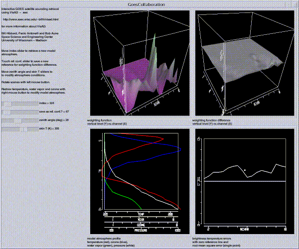