File:Map of the Wabanaki Confederacy Range.png
From HandWiki
Size of this preview: 800 × 420 pixels. Other resolutions: 640 × 336 pixels | 965 × 507 pixels.
Original file (965 × 507 pixels, file size: 166 KB, MIME type: image/png)
Summary
| Description |
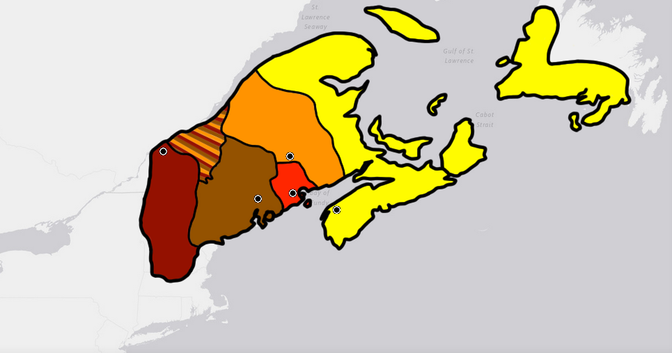
English: This is the max range of the Wabanaki Confederacy based off of cultural boundaries of the five tribal populations that made it up at around its formation in the early 1,600's. Yellow is the Miꞌkmaq. Orange is the Wəlastəkwewiyik (Maliseet), Red is the Passamaquoddy, Brown is the Penobscot, and Cayenne is the Western Abanaki. The large mixed area to the north was part of Wabanaki territory but is not part of the cultural boundaries of the individual 5 tribes. This may in part be due to it's recent acquisition (In relationship to the formation of Wabanaki) from Iroquois tribes that were pushed out of the area as identified by Samuel de Champlain during the establishment of Quebec City. Algonquin people would have started moving into the land around the same time the French would. |
| Date | |
| Source | Own work |
| Author | Wolastoq |
Licensing
I, the copyright holder of this work, hereby publish it under the following license:
| This file is made available under the Creative Commons CC0 1.0 Universal Public Domain Dedication. | |
| The person who associated a work with this deed has dedicated the work to the public domain by waiving all of their rights to the work worldwide under copyright law, including all related and neighboring rights, to the extent allowed by law. You can copy, modify, distribute and perform the work, even for commercial purposes, all without asking permission.
|
File history
Click on a date/time to view the file as it appeared at that time.
| Date/Time | Thumbnail | Dimensions | User | Comment | |
|---|---|---|---|---|---|
| current | 19:31, 24 August 2020 | | 965 × 507 (166 KB) | imagescommonswiki>Wolastoq | Newfoundland was not entirely inhabited by the Mi'kmaqs. The Beothuk shared the Island, living in the Northern and Eastern parts of the Island until their culture largely died out around the 1830s. The Mi'kmaq peoples would to this day survive as part of the Qalipu Mi'kmaq First Nation and Miawpukek Mi'kmaq First Nation on the Island. |
File usage
The following file is a duplicate of this file (more details):
- File:Map of the Wabanaki Confederacy Range.png from Wikimedia Commons
There are no pages that use this file.

