File:Maurya Empire, c.250 BCE 2.png
Original file (720 × 720 pixels, file size: 870 KB, MIME type: image/png)
Summary
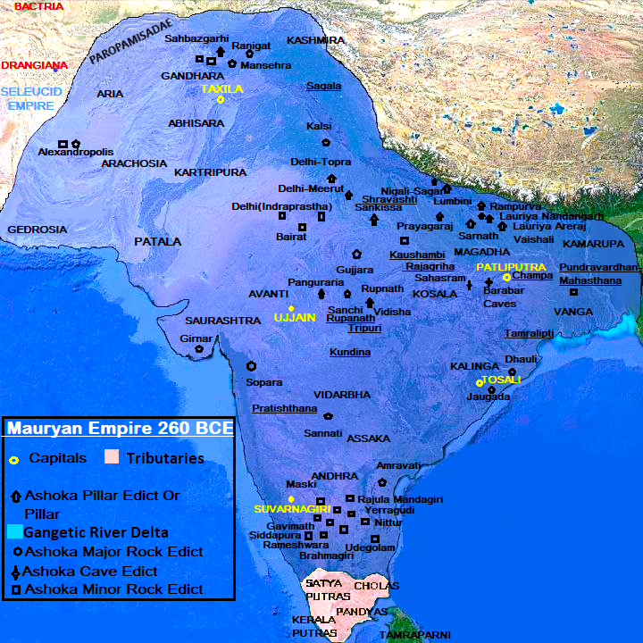
Maximum extent of the Maurya Empire, as shown by the location of Ashoka's inscriptions, and visualized by modern archaeologist : Dougald J. W. O'Reilly [1],old archeologist Myra Shackley[2]: modern historian : Upinder Singh[3],Jackson J. Spielvogel[4][5]Hugh Bowden[6];old historians:John Haywood[7];Patrick Karl O'Brien[8][9],H. C. Raychaudhuri [10],John F. Cady[11],Gerald Danzer[12],Vincent Arthur Smith;[13] Robert Roswell Palmer[14],Geoffrey Parker[15],R. C. Majumdar;[16] and historical geographer:Joseph E. Schwartzberg.[17]
- This map is based on the Book "Indian Historical Quarterly, Volume-13" which is published by ASI (Archeological Survey Of India) based on various inscriptions and ancient Greecian and Indian texts. https://archive.org/details/dli.calcutta.06445/page/n421/mode/1up
- Chandrgupta Maurya (322BCE) already won the Aria ,Kamboj ,Arachosia ,Gedrosia from Selucus.Bindusara expanded the empire by capturing whole Dakshinapatha. Ashoka defeated the Kalinga. ' Major Rock Edict XIII ' mentions about the victory of Ashoka over Kalinga.In Girnar Second Rock inscription Ashoka mentioned some detail about his Empire.
Historical Notes :
According to Strabo (64/63 BC–c.24 AD), the ceded territories bordered the Indus:
The geographical position of the tribes is as follows: along the Indus are the Paropamisadae, above whom lies the Paropamisus mountain: then, towards the south, the Arachoti: then next, towards the south, the Gedroseni, with the other tribes that occupy the seaboard; and the Indus lies, latitudinally, alongside all these places; and of these places, in part, some that lie along the Indus are held by Indians, although they formerly belonged to the Persians. Alexander [III 'the Great' of Macedon] took these away from the Arians and established settlements of his own, but Seleucus Nicator gave them to Sandrocottus [Chandragupta], upon terms of intermarriage and of receiving in exchange five hundred elephants. — Strabo 15.2.9[18]
According to Pliny (23/24 AD–c.79 AD) Seleucus surrendered the easternmost provinces of Arachosia, Gedrosia, Paropamisadae and perhaps also Aria. On the other hand, he was accepted by other satraps of the eastern provinces.
Most geographers, in fact, do not look upon India as bounded by the river Indus, but add to it the four satrapies of the Gedrose, the Arachotë, the Aria, and the Paropamisadë, the River Cophes thus forming the extreme boundary of India. According to other writers, however, all these territories, are reckoned as belonging to the country of the Aria. — Pliny, Natural History VI, 23[19]
Mauryan control of territory in what is now Afghanistan helped guard against invasion of India from the northwest. Chandragupta Maurya went on to expand his rule in India southward into the Deccan .[20]Sudarshana Lake is a man made lake in the Girnar Mountain ranges of Junagadh, in India. The lake was created sometime after 325 BCE upon the orders of Chandragupta Maurya, the founder and first emperor of the Maurya Empire. Chandragupta appointed Pushyagupta Vaishya, as a provisional governor of the Maurya Empire.[21]
Chandragupta conquest over Saurashtra and Sudarshana lake construction :
(L.8) for the sake of / ordered to be made by the Vaishya Pushyagupta, the provincial governor of the Maurya king Chandragupta; adorned with conduits for Ashoka the Maurya by the Yavana king Tushaspha while governing; and by the conduit ordered to be made by him, constructed in a manner worthy of a king (and) seen in that breach.
—Junagadh rock inscription of Rudradaman[22]
Ashoka's victory over Kalinga :
Beloved-of-the-Gods, King Priyadarsi(Ashoka)conquered the Kalingas eight years after his coronation. One hundred and fifty thousand were deported, one hundred thousand were killed and many more died (from other causes). After the Kalingas had been conquered, Beloved-of-the-Gods came to feel a strong inclination towards the Dharma, a love for the Dharma and for instruction in Dharma. Now Beloved-of-the-Gods feels deep remorse for having conquered the Kalingas.—Ashoka Rock Edict No. 13[23]
Licensing
This file is licensed under the Attribution-Share Alike 3.0 Unported (CC BY-SA 3.0) license. You are free:
- to share – to copy, distribute and transmit the work
- to remix – to adapt the work
Under the following conditions:
- attribution – You must give appropriate credit, provide a link to the license, and indicate if changes were made. You may do so in any reasonable manner, but not in any way that suggests the licensor endorses you or your use.
- share alike – If you remix, transform, or build upon the material, you must distribute your contributions under the same or compatible license as the original.
- ↑ https://books.google.nl/books?id=eyHTschgg50C&pg=PA178&redir_esc=y#v=onepage&q&f=false
- ↑ Shackley, Myra L. (2006). Atlas of travel and tourism development. Internet Archive. Amsterdam ; Boston : Elsevier. ISBN 978-0-7506-6348-9. http://archive.org/details/atlasoftraveltou0000shac.
- ↑ https://archive.org/details/history-of-ancient-and-early-medeival-india-from-the-stone-age-to-the-12th-century-pdfdrive
- ↑ Spielvogel, Jackson J. (2012). Western civilization. Internet Archive. Boston, MA : Wadsworth Cengage Learning. ISBN 978-0-495-91329-0. http://archive.org/details/westerncivilizat08edspie.
- ↑ https://books.google.nl/books?id=cCdmEAAAQBAJ&pg=PT143&redir_esc=y#v=onepage&q&f=false
- ↑ The Times ancient civilizations. Internet Archive. London : Times Books. 2002. ISBN 978-0-00-710859-6. http://archive.org/details/timesancientcivi0000unse.
- ↑ Haywood, John (1997). Atlas of world history. Internet Archive. New York : Barnes & Noble Books. ISBN 978-0-7607-0687-9. http://archive.org/details/atlasofworldhist00hayw.
- ↑ Philip's Atlas of World History: From the Origins of Humanity to the Year 2000. Internet Archive. The Softback Preview. 1999. ISBN 978-0-540-07858-5. http://archive.org/details/philipsatlasofwo0000unse_u6t7.
- ↑ https://books.google.nl/books?id=ffZy5tDjaUkC&pg=PA46&redir_esc=y#v=onepage&q&f=false
- ↑ https://www.routledge.com/India-The-Ancient-Past-A-History-of-the-Indian-Subcontinent-from-c-7000/Avari/p/book/9781138828216
- ↑ Cady, John F. (John Frank) (1964). Southeast Asia: its historical development. Internet Archive. New York, McGraw-Hill. http://archive.org/details/southeastasiaits0000cady_v1t8.
- ↑ Danzer, Gerald A. (2000). An atlas of world history. Internet Archive. Ann Arbor, MI : Borders Press. ISBN 978-0-681-46572-5. http://archive.org/details/atlasofworldhist0000danz.
- ↑ Smith, Vincent Arthur, Press The Oxford History of India: From the Earliest Times to the End of 1911, pp. 104–106, https://books.google.com/books?id=p2gxAQAAMAAJ&pg=PA104%7Cyear=1920%7Cpublisher=Clarendon Press
- ↑ Rand McNally and Company; Palmer, R. R. (Robert Roswell) (1965). Rand McNally atlas of world history. Internet Archive. Chicago. http://archive.org/details/randmcnallyatla00rand.
- ↑ The Times compact history of the world. Internet Archive. London : Times Books. 2008. ISBN 978-0-00-726731-6. http://archive.org/details/timescompacthist0000unse_g4l2.
- ↑ Majumdar, R. C.; Raychaudhuri, H. C.; Datta, Kalikinkar, & Company An Advanced History of India, p. 104, https://books.google.com/books?id=MyIWMwEACAAJ%7Cedition=Second%7Cyear=1950%7Cpublisher=Macmillan & Company
- ↑ Schwartzberg, Joseph E. A Historical Atlas of South Asia , 2nd ed. (University of Minnesota, 1992), Plate III.B.4b (p.18) and Plate XIV.1a-c (p.145) |url=https://dsal.uchicago.edu/reference/schwartzberg/ |date=26 January 2021
- ↑ Strabo, Geography, xv.2.9
- ↑ Pliny, Natural History VI, 23
- ↑ Grainger 2014, pp. 108–110.
- ↑ Epigraphia Indica, Vol. VIII. Calcutta: Office of the Superintendent of Government Printing, 1905-6, 45-49
- ↑ "Junagadh Rock Inscription of Rudradaman", Project South Asia.
- ↑ Allen, Charles (2012) (in en). Ashoka: The Search for India's Lost Emperor. Little, Brown Book Group. p. 82. ISBN 9781408703885. https://books.google.com/books?id=K4vHjbUtf_4C&pg=PT82. Retrieved 1 May 2018.
File history
Click on a date/time to view the file as it appeared at that time.
| Date/Time | Thumbnail | Dimensions | User | Comment | |
|---|---|---|---|---|---|
| current | 22:03, 9 November 2023 | | 720 × 720 (870 KB) | Magadhian Historian (talk | contribs) | Map according to Greek historians and Ashoka inscriptions. |
You cannot overwrite this file.
File usage
The following 6 pages use this file:

