File:Ship Rock NASA.jpg

From HandWiki

Ship_Rock_NASA.jpg(500 × 522 pixels, file size: 404 KB, MIME type: image/jpeg)

This file is from a shared repository and may be used by other projects. The description on its file description page there is shown below.

Summary

Description
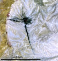
English: Cropped, marked, and lower-resolution version of NASA Visible Earth image of Ship Rock, about 20 km southwest of the town of Shiprock, New Mexico "This image of the Shiprock formation was captured by the Advanced Spaceborne Thermal Emission and Reflection Radiometer (ASTER) sensor on NASA’s Terra satellite on June 2, 2006. The image is not photo-like … …"
Date Taken on 2 June 2006
Source http://earthobservatory.nasa.gov/Newsroom/NewImages/images.php3?img_id=17316
Author NASA image created by Jesse Allen, Earth Observatory
Other versions

Summary

Licensing

Public domain This file is in the public domain in the United States because it was solely created by NASA. NASA copyright policy states that "NASA material is not protected by copyright unless noted". (See Template:PD-USGov, NASA copyright policy page or JPL Image Use Policy.)
Warnings:

Captions

Add a one-line explanation of what this file represents

Items portrayed in this file

depicts

2 June 2006

413,798 byte

522 pixel

500 pixel

image/jpeg

d1e7ce8dca331483a8a5dc5e733473610c3c2a21

File history

Click on a date/time to view the file as it appeared at that time.

Date/TimeThumbnailDimensionsUserComment
current12:25, 25 June 2006Thumbnail for version as of 12:25, 25 June 2006500 × 522 (404 KB)imagescommonswiki>Omphacite~commonswikiCropped, marked, and lower-resolution version of NASA Visible Earth image of Ship Rock, about 20 km southwest of the town of Shiprock, New Mexico "This image of the Shiprock formation was captured by the Advanced Spaceborne Thermal Emission and Reflection

The following file is a duplicate of this file (more details):

The following page uses this file:

Metadata