Earth:Steamboat Rock (Dinosaur National Monument)
| Steamboat Rock | |
|---|---|
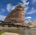
 Steamboat Rock, south aspect | |
| Highest point | |
| Elevation | 6,074 ft (1,851 m) [1] |
| Prominence | 294 ft (90 m) [1] |
| Parent peak | Jenny Lind Rock[1] |
| Isolation | 0.9 mi (1.4 km) [1] |
| Coordinates | [ ⚑ ] : 40°32′06″N 108°59′12″W / 40.5349638°N 108.9867849°W [2] |
| Geography | |
Lua error in Module:Location_map at line 522: Unable to find the specified location map definition: "Module:Location map/data/Colorado" does not exist.
| |
| Location | Dinosaur National Monument Moffat County, Colorado, United States |
| Parent range | Uinta Mountains |
| Topo map | USGS Canyon of Lodore South |
| Geology | |
| Age of rock | Permian-Pennsylvanian |
| Type of rock | Weber Sandstone |
| Climbing | |
| Easiest route | class 5+ climbing[1] |
Steamboat Rock, reaching an elevation of 6,074 ft (1,851 m) is a promontory located in the eastern Uinta Mountains, in Moffat County of northwest Colorado, United States.[2] This iconic landmark of Dinosaur National Monument is situated at the confluence of the Green River and Yampa River. Precipitation runoff from this feature drains into the Green River. This geographical formation was originally named "Echo Rock" in John Wesley Powell's 1875 report, The Exploration of the Colorado River and Its Canyons. The Steamboat name first appeared on a 1941 United States Geological Survey map of Dinosaur National Monument.[2] The area around it still retains the Echo Park name applied by Powell during the Powell Geographic Expedition of 1869.
Geology
Steamboat Rock is a mile-long, 1,000-ft high, slender peninsular ridge within a meander of the Green River. It is composed almost entirely of Permian-Pennsylvanian Weber Sandstone, with a thin layer of Park City Formation caprock.[3] It is located where the river exits Lodore Canyon and enters Echo Park. The river drops 15 feet as it courses around Steamboat Rock.
Gallery

From the SSW
From the SSW

The south end of Steamboat Rock

Confluence of the Green and Yampa Rivers below the east wall of Steamboat Rock

From the southwest

From the west
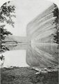
Earliest known image of Steamboat Rock (1871)


.jpg)


Climate
Spring and fall are the most favorable seasons to visit Steamboat Rock. According to the Köppen climate classification system, it is located in a semi-arid climate zone, with temperatures averaging between 0 °F to 30 °F in January, and 50 °F to 100 °F in July.[4] Typical of high deserts, summer temperatures can be exceedingly hot, while winter temperatures can be very cold. Snowfall is common, but the snow melts rapidly in the arid and sunny climate. Rainfall is very low, and the evaporation rate classifies the area as desert, even though the rainfall exceeds 10 inches.
Script error: No such module "weather box".
References
- ↑ 1.0 1.1 1.2 1.3 1.4 "Steamboat Rock - 6,074' CO". https://listsofjohn.com/peak/6464. Retrieved 2020-10-02.
- ↑ 2.0 2.1 2.2 U.S. Geological Survey Geographic Names Information System: Steamboat Rock
- ↑ H. E. Thomas, Hydrologic Reconnaissance of the Green River in Utah and Colorado, US Department of the Interior, 1962, page 10.
- ↑ Weather Dinosaur National Monument. National Park Service.gov
- ↑ "Seasonal Temperature and Precipitation Information". Western Regional Climate Center. http://www.wrcc.dri.edu/cgi-bin/cliMAIN.pl?codino. Retrieved May 3, 2013.
External links
- Steamboat Rock: Weather forecast
 |  |

