Module:Location map/data/Italy Milan admin/doc
From HandWiki
< Module:Location map | data/Italy Milan admin
Revision as of 10:42, 14 January 2019 by imported>Frietjes (←Created page with '<!-- Place categories where indicated at the bottom of this page; interwikis at Wikidata --> {{Module:Location map/data/doc | see also = * Module:Location map...')
This is the documentation page for Module:Location map/data/Italy Milan admin
| name | Milan | |||
|---|---|---|---|---|
| border coordinates | ||||
| 45.540756322 | ||||
| 9.03425608 | ←↕→ | 9.284531227 | ||
| 45.381708071 | ||||
| map center | [ ⚑ ] 45°27′40″N 9°09′34″E / 45.4612321965°N 9.1593936535°E | |||
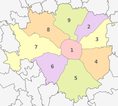
| image | Milan, administrative divisions - Nmbrs - colored.svg
| |||

| ||||
| mark | Map pointer.svg
| |||
| marksize | 14 | |||
Module:Location map/data/Italy Milan admin is a location map definition used to overlay markers and labels on an equirectangular projection map of Milan. The markers are placed by latitude and longitude coordinates on the default map or a similar map image.
Usage
These definitions are used by the following templates when invoked with parameter "Italy Milan admin":
{{Location map|Italy Milan admin |...}}{{Location map many|Italy Milan admin |...}}{{Location map+|Italy Milan admin |...}}{{Location map~|Italy Milan admin |...}}
Map definition
name = Milan- Name used in the default map caption
image = Milan, administrative divisions - Nmbrs - colored.svg- The default map image, without "Image:" or "File:"
top = 45.540756322- Latitude at top edge of map, in decimal degrees
bottom = 45.381708071- Latitude at bottom edge of map, in decimal degrees
left = 9.03425608- Longitude at left edge of map, in decimal degrees
right = 9.284531227- Longitude at right edge of map, in decimal degrees
mark = Map pointer.svg ( )
)- The default mark image to display with this map. This can be overridden by the
markparameter in Template:Location map, which would otherwise default to Red pog.svg ( ).
).
- The default mark image to display with this map. This can be overridden by the
marksize = 14- The default mark size (in pixels) for the mark image displayed with this map (should not include
px, for examplemarksize=14, notmarksize=14px). This can be overridden by themarksizeparameter in Template:Location map, which would otherwise default to 8.
- The default mark size (in pixels) for the mark image displayed with this map (should not include
Precision
Longitude: from West to East this map definition covers 0.2503 degrees.
- At an image width of 200 pixels, that is 0.0013 degrees per pixel.
- At an image width of 1000 pixels, that is 0.0003 degrees per pixel.
Latitude: from North to South this map definition covers 0.159 degrees.
- At an image height of 200 pixels, that is 0.0008 degrees per pixel.
- At an image height of 1000 pixels, that is 0.0002 degrees per pixel.
See also
- Module:Location map/data/Italy
- Module:Location map/data/Italy Milan
- Module:Location map/data/Italy Milan Central
Location map templates
- Template:Location map, to display one mark and label using latitude and longitude
- Template:Location map many, to display up to nine marks and labels
- Template:Location map+, to display an unlimited number of marks and labels
