File:1780 Raynal and Bonne Map of New England and the Maritime Provinces - Geographicus - Canada-bonne-1780.jpg
From HandWiki

Size of this preview: 800 × 567 pixels. Other resolutions: 640 × 454 pixels | 2,500 × 1,772 pixels.
Original file (2,500 × 1,772 pixels, file size: 1.45 MB, MIME type: image/jpeg)
| Rigobert Bonne: L'Isle De Terre-Neuve, L'Acadie ou La Nouvelle Ecosse
( |
|||||||||||||||||||||||
|---|---|---|---|---|---|---|---|---|---|---|---|---|---|---|---|---|---|---|---|---|---|---|---|
| Artist |
|
||||||||||||||||||||||
| Title |
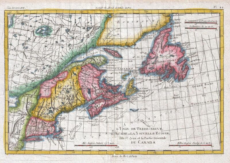
L'Isle De Terre-Neuve, L'Acadie ou La Nouvelle Ecosse |
||||||||||||||||||||||
| Description |
English: A fine example of Rigobert Bonne and Guilleme Raynal’s 1780 map of the Northeast United States and Eastern Canada. This highly detailed map covers the eastern coast of the United States from a portion of New Jersey and New York in the south as far north as the Canadian Maritime Provinces of Nova Scotia, New Brunswick, and Newfoundland. Identifies Martha’s Vineyard and Nantucket Island. Shows all principal harbors, ports, bays and islands. Along the coast, shoals such as the Grand Banks and the fisheries off Cape Cod are depicted, as this area was extremely important to the North American cod fishing industry through the 18th century. Drawn by R. Bonne for G. Raynal’s Atlas de Toutes les Parties Connues du Globe Terrestre, Dressé pour l'Histoire Philosophique et Politique des Établissemens et du Commerce des Européens dans les Deux Indes . |
||||||||||||||||||||||
| Date | 1780 (undated) | ||||||||||||||||||||||
| Dimensions | height: 9 in (22.8 cm); width: 13 in (33 cm) | ||||||||||||||||||||||
| Accession number |
Geographicus link: Canada-bonne-1780 |
||||||||||||||||||||||
| Source/Photographer |
Raynal, G., Atlas de Toutes les Parties Connues du Globe Terrestre, Dressé pour l'Histoire Philosophique et Politique des Établissemens et du Commerce des Européens dans les Deux Indes, 1780.
|
||||||||||||||||||||||
| Permission (Reusing this file) |
|
||||||||||||||||||||||
File history
Click on a date/time to view the file as it appeared at that time.
| Date/Time | Thumbnail | Dimensions | User | Comment | |
|---|---|---|---|---|---|
| current | 05:51, 24 March 2011 | | 2,500 × 1,772 (1.45 MB) | imagescommonswiki>BotMultichillT | {{subst:User:Multichill/Geographicus |link=http://www.geographicus.com/P/AntiqueMap/Canada-bonne-1780 |product_name=1780 Raynal and Bonne Map of New England and the Maritime Provinces |map_title=L'Isle De Terre-Neuve, L'Acadie ou La Nouvelle Ecosse |descr |
File usage
The following file is a duplicate of this file (more details):
The following page uses this file:

