File:Antarctic Peninsula satellite image.jpg
From HandWiki

Size of this preview: 490 × 599 pixels. Other resolutions: 392 × 480 pixels | 1,509 × 1,846 pixels.
Original file (1,509 × 1,846 pixels, file size: 706 KB, MIME type: image/jpeg)
Summary
| Description |
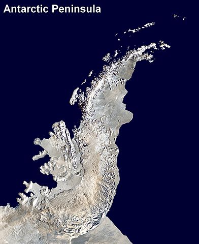
English: Antarctic Peninsula satellite image. An orthographic projection of NASA's Blue Marble data set (1 km resolution global satellite composite). "MODIS observations of polar sea ice were combined with observations of Antarctica made by the National Oceanic and Atmospheric Administration’s AVHRR sensor—the Advanced Very High Resolution Radiometer." Image was generated using a custom C program for handling the Blue Marble files, with orthographic projection formulas from MathWorld.
The black pixels are presumed to be due to missing data in the land/sea mask used in making the original Blue Marble image.
|
||
| Date | (UTC) | ||
| Source | |||
| Author |
|
Licensing
| This work has been released into the public domain by its author, Anna Frodesiak. This applies worldwide. In some countries this may not be legally possible; if so: |
Original upload log
This image is a derivative work of the following images:
- File:Antarctica_6400px_from_Blue_Marble.jpg licensed with PD-user
- 2006-10-05T14:21:53Z Davepape 6400x6400 (3472802 Bytes) touched up part with missing data
- 2006-10-05T07:49:09Z Davepape 6400x6400 (3472752 Bytes) {{Information |Description=[[w:Antarctica|Antarctica]]. An orthographic projection of NASA's Blue Marble data set (1 km resolution global satellite composite). "MODIS observations of polar sea ice were combined with observa
Uploaded with derivativeFX
File history
Click on a date/time to view the file as it appeared at that time.
| Date/Time | Thumbnail | Dimensions | User | Comment | |
|---|---|---|---|---|---|
| current | 18:08, 5 April 2009 | | 1,509 × 1,846 (706 KB) | imagescommonswiki>Anna Frodesiak | {{Information |Description=Antarctic Peninsula satellite image. An orthographic projection of NASA's Blue Marble data set (1 km resolution global satellite composite). "MODIS observations of polar sea ice were combined with observations of Antarctica made |
File usage
The following file is a duplicate of this file (more details):
- File:Antarctic Peninsula satellite image.jpg from Wikimedia Commons
The following page uses this file:

