File:Image annotations.jpg
From HandWiki
No higher resolution available.
Image_annotations.jpg (500 × 500 pixels, file size: 35 KB, MIME type: image/jpeg)
Summary
| Description |
English: Image annotations
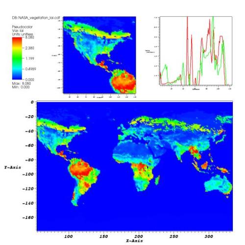
The featured plot shows Leaf Area Index (LAI), a measure of global vegetative matter, from a NetCDF dataset. The primary plot is the large plot at the bottom, which shows the LAI for the whole world. The plots on top are actually annotations that contain images that VisIt generated earlier. Image annotations can be used to include material that enhances a visualization such as auxiliary plots, images of experimental data, project logos, etc. The data in the featured image was obtained via the Internet from NASA. |
| Date | Updated: November 8, 2007 |
| Source | Visualizations that have been created with VisIt. at wci.llnl.gov |
| Author | UCRL |
Licensing
This work is in the public domain in the United States because it is a work prepared by an officer or employee of the United States Government as part of that person’s official duties under the terms of Title 17, Chapter 1, Section 105 of the US Code.
Note: This only applies to original works of the Federal Government and not to the work of any individual U.S. state, territory, commonwealth, county, municipality, or any other subdivision. This template also does not apply to postage stamp designs published by the United States Postal Service since 1978. (See § 313.6(C)(1) of Compendium of U.S. Copyright Office Practices). It also does not apply to certain US coins; see The US Mint Terms of Use.
|
 | |
| This file has been identified as being free of known restrictions under copyright law, including all related and neighboring rights. | ||
File history
Click on a date/time to view the file as it appeared at that time.
| Date/Time | Thumbnail | Dimensions | User | Comment | |
|---|---|---|---|---|---|
| current | 17:26, 10 July 2008 | | 500 × 500 (35 KB) | imagescommonswiki>Mdd | {{Information |Description={{en|1=Image annotations The featured plot shows Leaf Area Index (LAI), a measure of global vegetative matter, from a NetCDF dataset. The primary plot is the large plot at the bottom, which shows the LAI for the whole world. Th |
File usage
The following file is a duplicate of this file (more details):
- File:Image annotations.jpg from Wikimedia Commons
The following page uses this file:

