File:Kingdom of Numidia-02.png
From HandWiki

Size of this preview: 800 × 346 pixels. Other resolutions: 640 × 277 pixels | 2,246 × 971 pixels.
Original file (2,246 × 971 pixels, file size: 495 KB, MIME type: image/png)
Summary
| Description |
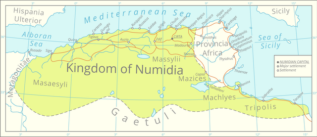
English: This map was assembled using the boundaries of this map, Roman road data from this [1] dataset, river and lake data from the Pergamon Atlas as well as settlement significance from the Barrington Atlas.
The graphics were assembled in QGIS and processed in Adobe Illustrator. All data is projected in the Lambert azimuthal equal-area projection. |
| Date | |
| Source | Own work |
| Author | Cattette |
Licensing
I, the copyright holder of this work, hereby publish it under the following license:
This file is licensed under the Creative Commons Attribution 4.0 International license.
- You are free:
- to share – to copy, distribute and transmit the work
- to remix – to adapt the work
- Under the following conditions:
- attribution – You must give appropriate credit, provide a link to the license, and indicate if changes were made. You may do so in any reasonable manner, but not in any way that suggests the licensor endorses you or your use.
File history
Click on a date/time to view the file as it appeared at that time.
| Date/Time | Thumbnail | Dimensions | User | Comment | |
|---|---|---|---|---|---|
| current | 19:26, 29 March 2021 | | 2,246 × 971 (495 KB) | imagescommonswiki>Cattette | Uploaded own work with UploadWizard |
File usage
The following file is a duplicate of this file (more details):
- File:Kingdom of Numidia-02.png from Wikimedia Commons
The following page uses this file:

