File:Map of The east barbarian 6.png
From HandWiki

Size of this preview: 690 × 600 pixels. Other resolutions: 552 × 480 pixels | 1,077 × 936 pixels.
Original file (1,077 × 936 pixels, file size: 466 KB, MIME type: image/png)
Summary
| Description |
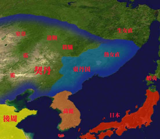
English: 10th century Manchuria, Korea, the Japanese Islands.
日本語:10世紀の満州、朝鮮半島、日本列島。 |
| Date | |
| Source | File:Whole world - land and oceans 12000.jpg modified by トムル、『増補版 標準世界史地図』(吉川弘文館、2022年) |
| Author | トムル |
Licensing
I, the copyright holder of this work, hereby publish it under the following license:
| This file is made available under the Creative Commons CC0 1.0 Universal Public Domain Dedication. | |
| The person who associated a work with this deed has dedicated the work to the public domain by waiving all of their rights to the work worldwide under copyright law, including all related and neighboring rights, to the extent allowed by law. You can copy, modify, distribute and perform the work, even for commercial purposes, all without asking permission.
|
File history
Click on a date/time to view the file as it appeared at that time.
| Date/Time | Thumbnail | Dimensions | User | Comment | |
|---|---|---|---|---|---|
| current | 07:49, 11 May 2011 | | 1,077 × 936 (466 KB) | imagescommonswiki>トムル | {{Information |Description ={{en|1=10th century Manchuria, Korea, the Japanese Islands. }} {{ja|1=10世紀の満州、朝鮮半島、日本列島。}} |Source =derivative work of File:Whole world - land and oceans.jpg |Author =トムル |
File usage
The following file is a duplicate of this file (more details):
- File:Map of The east barbarian 6.png from Wikimedia Commons
The following page uses this file:

