File:Morrison Formation from near Notom-Bullfrog Road in southern Capitol Reef National Park.jpg
Morrison_Formation_from_near_Notom-Bullfrog_Road_in_southern_Capitol_Reef_National_Park.jpg (800 × 600 pixels, file size: 497 KB, MIME type: image/jpeg)
Summary
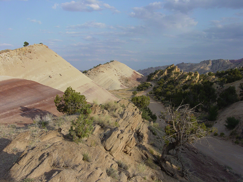
USGS photo from [1] Red and gray shale of the Morrison Formation form from volcanic ash deposited an a broad coastal floodplain during the Jurassic Period (between 208 and 144 million years ago). The sand bed in the foreground probably represent old stream channel deposits. When the sediments were originally deposited they were nearly flat lying, but the tectonic forces that shaped the Waterpocket Fold in the Tertiary Period resulted in the rock layers dipping steeply to the left. These outcrops are along the Notom-Bullfrog Road in southern Capitol Reef National Park.
Licensing
This work is in the public domain in the United States because it is a work prepared by an officer or employee of the United States Government as part of that person’s official duties under the terms of Title 17, Chapter 1, Section 105 of the US Code.
Note: This only applies to original works of the Federal Government and not to the work of any individual U.S. state, territory, commonwealth, county, municipality, or any other subdivision. This template also does not apply to postage stamp designs published by the United States Postal Service since 1978. (See § 313.6(C)(1) of Compendium of U.S. Copyright Office Practices). It also does not apply to certain US coins; see The US Mint Terms of Use.
|
 | |
| This file has been identified as being free of known restrictions under copyright law, including all related and neighboring rights. | ||
File history
Click on a date/time to view the file as it appeared at that time.
| Date/Time | Thumbnail | Dimensions | User | Comment | |
|---|---|---|---|---|---|
| current | 21:28, 15 March 2006 | | 800 × 600 (497 KB) | imagescommonswiki>Mav | USGS photo from [http://3dparks.wr.usgs.gov/capitol2/html/3d068.html] Red and gray shale of the Morrison Formation form from volcanic ash deposited an a broad coastal floodplain during the Jurassic Period (between 208 and 144 million years ago). The sand |
File usage
The following file is a duplicate of this file (more details):
The following page uses this file:

