File:Partitions of Moldavia.jpg
From HandWiki

Size of this preview: 215 × 597 pixels. Other resolutions: 172 × 480 pixels | 665 × 1,848 pixels.
Original file (665 × 1,848 pixels, file size: 635 KB, MIME type: image/jpeg)

|
This historical map image could be re-created using vector graphics as an SVG file. This has several advantages; see Commons:Media for cleanup for more information. If an SVG form of this image is available, please upload it and afterwards replace this template with
{{vector version available|new image name}}.
It is recommended to name the SVG file “Partitions of Moldavia.svg”—then the template Vector version available (or Vva) does not need the new image name parameter. |


Summary
| Description |
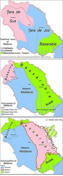
English: Historic map: partitions of Moldavia |
| Date | |
| Source | Own work |
| Author | Aoleuvaidenoi |
Licensing
| I, the copyright holder of this work, release this work into the public domain. This applies worldwide. In some countries this may not be legally possible; if so: I grant anyone the right to use this work for any purpose, without any conditions, unless such conditions are required by law. |
File history
Click on a date/time to view the file as it appeared at that time.
| Date/Time | Thumbnail | Dimensions | User | Comment | |
|---|---|---|---|---|---|
| current | 04:53, 9 April 2019 | 665 × 1,848 (635 KB) | imagescommonswiki>Julieta39 | Correct Iași (Яссы) County since the same map. |
File usage
The following file is a duplicate of this file (more details):
- File:Partitions of Moldavia.jpg from Wikimedia Commons
The following 3 pages use this file:

