File:Yamhad and Vassals.png
From HandWiki

Size of this preview: 755 × 599 pixels. Other resolutions: 605 × 480 pixels | 1,325 × 1,052 pixels.
Original file (1,325 × 1,052 pixels, file size: 1.43 MB, MIME type: image/png)
Summary
| Description |
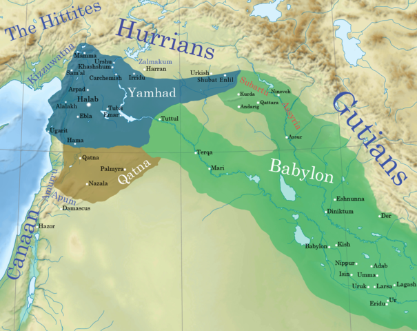
English: Yamhad kingdom at its greatest extent including vassal kingdoms. the Babylonian empire include vassals not directly annexed, mainly Subartu and Assyria. Regarding the borders of Yamhad:
|
| Date | |
| Source | |
| Author |
|
| This is a retouched picture, which means that it has been digitally altered from its original version. Modifications: Yamhad in the levant. The original can be viewed here: Near East topographic map-blank.svg:
|
Licensing
I, the copyright holder of this work, hereby publish it under the following license:
This file is licensed under the Creative Commons Attribution-Share Alike 4.0 International license.
- You are free:
- to share – to copy, distribute and transmit the work
- to remix – to adapt the work
- Under the following conditions:
- attribution – You must give appropriate credit, provide a link to the license, and indicate if changes were made. You may do so in any reasonable manner, but not in any way that suggests the licensor endorses you or your use.
- share alike – If you remix, transform, or build upon the material, you must distribute your contributions under the same or compatible license as the original.
Original upload log
This image is a derivative work of the following images:
- File:Near_East_topographic_map-blank.svg licensed with Cc-by-sa-3.0,2.5,2.0,1.0, GFDL
- 2009-08-18T18:31:37Z Sémhur 2425x1581 (2442670 Bytes) 3 - New try
- 2009-08-17T15:39:22Z Sémhur 2425x1581 (1815374 Bytes) 2 - With the background...
- 2009-08-17T15:37:36Z Sémhur 2425x1581 (2836 Bytes) {{Information |Description={{en|1=Blank physical map of the [[:en:Near East|Near East]]}} {{fr|1=Carte physique vierge du [[:fr:Proche-Orient|Proche-Orient]].}} |Source={{own}} |Author=[[User:Sémhur|Sémhur]] |Date=2008-08-1
File history
Click on a date/time to view the file as it appeared at that time.
| Date/Time | Thumbnail | Dimensions | User | Comment | |
|---|---|---|---|---|---|
| current | 03:56, 30 December 2016 | | 1,325 × 1,052 (1.43 MB) | imagescommonswiki>Attar-Aram syria | shubat enlil vassalage |
File usage
The following file is a duplicate of this file (more details):
- File:Yamhad and Vassals.png from Wikimedia Commons
The following page uses this file:

