| Display title | Bathymetric chart |
| Default sort key | Bathymetric chart |
| Page length (in bytes) | 9,532 |
| Namespace ID | 0 |
| Page ID | 235646 |
| Page content language | en - English |
| Page content model | wikitext |
| Indexing by robots | Allowed |
| Number of redirects to this page | 0 |
| Counted as a content page | Yes |
| Page image | 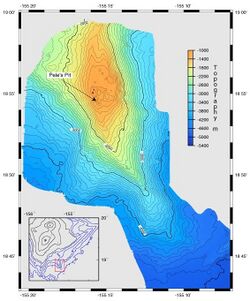 |
| HandWiki item ID | None |
| Edit | Allow all users (infinite) |
| Move | Allow all users (infinite) |
| Page creator | imported>MedAI |
| Date of page creation | 16:46, 6 February 2024 |
| Latest editor | imported>MedAI |
| Date of latest edit | 16:46, 6 February 2024 |
| Total number of edits | 1 |
| Recent number of edits (within past 90 days) | 0 |
| Recent number of distinct authors | 0 |
Description | Content |
Article description: (description)
This attribute controls the content of the description and og:description elements. | A bathymetric chart is a type of isarithmic map that depicts the submerged topography and physiographic features of ocean and sea bottoms. Their primary purpose is to provide detailed depth contours of ocean topography as well as provide the size, shape and distribution of underwater features. Topographic... |


