| Display title | Place:United Nations geoscheme for Africa |
| Default sort key | United Nations Geoscheme For Africa |
| Page length (in bytes) | 3,781 |
| Namespace ID | 3052 |
| Namespace | Place |
| Page ID | 862749 |
| Page content language | en - English |
| Page content model | wikitext |
| Indexing by robots | Allowed |
| Number of redirects to this page | 0 |
| Counted as a content page | Yes |
| Page image | 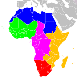 |
| HandWiki item ID | None |
| Edit | Allow all users (infinite) |
| Move | Allow all users (infinite) |
| Page creator | imported>Carolyn |
| Date of page creation | 10:39, 5 March 2023 |
| Latest editor | imported>Carolyn |
| Date of latest edit | 10:39, 5 March 2023 |
| Total number of edits | 1 |
| Recent number of edits (within past 90 days) | 0 |
| Recent number of distinct authors | 0 |
Description | Content |
Article description: (description)
This attribute controls the content of the description and og:description elements. | The following is an alphabetical list of subregions in the United Nations geoscheme for Africa, used by the United Nations and maintained by the UNSD department for statistical purposes.
Of the list below, the British Indian Ocean Territory, the French Southern Territories, Mayotte, Réunion, and Saint... |


