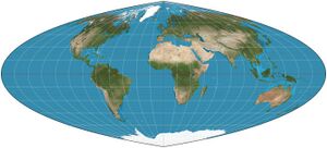
Quartic authalic projection: Difference between revisions
From HandWiki
imported>BotanyGa (fixing) |
(No difference)
|
Latest revision as of 11:05, 8 May 2022
Short description: Pseudocylindrical equal-area map projection
In cartography, the quartic authalic projection is an equal-area projection developed by Karl Siemon in 1937 and independently by O.S. Adams in 1944.[1] The meridians in this projection are fourth-order polynomial curves.[2] The projection is similar to the sinusoidal projection in appearance and distortion properties.
References
 |


