Earth:Laguna de Ayarza
From HandWiki
Revision as of 03:53, 25 September 2021 by imported>Jport (over-write)
| Laguna de Ayarza | |
|---|---|
 Laguna de Ayarza, Guatemala | |
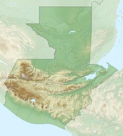
| Location | Casillas, Santa Rosa |
| Coordinates | [ ⚑ ] : 14°25′N 90°7′W / 14.417°N 90.117°W |
| Lake type | Crater lake |
| rivers, streams, precipitation">Primary inflows | none |
| rivers, streams, evaporation">Primary outflows | none |
| Basin countries | Guatemala |
| Surface area | 14 km2 (5.4 sq mi) |
| Max. depth | 230 m (750 ft) |
| Surface elevation | 1,409 m (4,623 ft) |
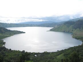
Laguna de Ayarza (Spanish pronunciation: [laˈɣuna ðe aˈʝaɾsa]) is a crater lake in Guatemala. The lake is a caldera that was created some 20,000 years ago by a catastrophic eruption that destroyed a twinned volcano and blanketed the entire region with a layer of pumice.[1] The lake has a surface area of 14 km² and a maximum depth of 230 m.[2] The lake has a surface elevation of 1409 m.[3]
References
- ↑ Poppe, L.; Paull, C; Newhall, C; Bradbury, J; Ziagos, J (June 1985). "A geophysical and geological study of Laguna de Ayarza, a Guatemalan caldera lake". Journal of Volcanology and Geothermal Research 25 (1–2): 125–144. doi:10.1016/0377-0273(85)90008-3. Bibcode: 1985JVGR...25..125P.
- ↑ (xls) Wetland Inv - Guatemala. Ducks Unlimited. http://www.ducks.org/media/Conservation/LAC/_documents/Guatemala_DSpa.xls. Retrieved 18 July 2008.
- ↑ Bohnenberger, Otto H.. "Los focos eruptivos cuaternarios de Guatemala". INSIVUMEH. http://www.insivumeh.gob.gt/geofisica/volcanes%20de%20Guatemala.htm. Retrieved 2010-05-05.
External links
 |


