Earth:Pavy Formation
From HandWiki
Revision as of 23:46, 29 August 2022 by imported>WikiEd2 (fixing)
| Pavy Formation Stratigraphic range: Thanetian | |
|---|---|
| Type | Formation |
| Lithology | |
| Primary | Siltstone |
| Other | Coal |
| Location | |
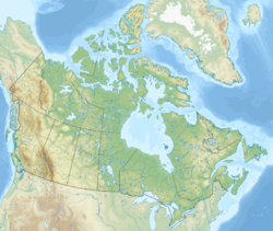
| Coordinates | [ ⚑ ] : 81°42′N 64°24′W / 81.7°N 64.4°W |
| Paleocoordinates | [ ⚑ ] 74°18′N 13°18′W / 74.3°N 13.3°W |
| Region | Ellesmere Island, Nunavut |
| Country | |
| Extent | Sverdrup Basin |
| Type section | |
| Named for | Pavy River |
The Pavy Formation is a geologic formation in Nunavut. It preserves fossil insects of Carabites feildenianus,[1] dating back to the Thanetian stage of the Paleocene period.
Description
The Pavy Formation is interpreted to be fluvial in origin. Trough-crossbedded sandstone facies dominate this formation and were probably channel deposits of a braided river system, with interbeds of siltstone and mudrock representing floodplain deposits. Where thicker intervals of mudrock occur, backswamp ponds or shallow-lake conditions were probably present. Only at Watercourse Valley and Pavy River did conditions stabilize long enough for swamps to develop, producing thick coal beds.
See also
- List of fossiliferous stratigraphic units in Nunavut
- Margaret Formation
References
- ↑ Heer, 1878
Bibliography
- Heer, O. 1878. Die Miocene Flora des Grinnell-Landes gegründet auf die von Capitan H.E. Feilden und Dr. E. Moss in der Nähe des Kap Murchison gesammelten fossilen Pflanzen. Flora Fossilis Arctica: Die Fossile Flora der Polarländer 5. 1-38.
 |


