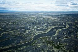
Earth:Lost Jim Lava Flow
From HandWiki
Revision as of 19:33, 29 August 2021 by imported>Smart bot editor (add)
The Lost Jim Lava Flow, located in the heart of the Seward Peninsula in Alaska, is a Holocene lava flow in the Bering Land Bridge National Preserve. The name originates from a member of a USGS research team who became separated from the rest of the group while mapping the lava flow in 1947.[1] The Lost Jim cone, its largest vent, is located at [ ⚑ ] 65°29′19″N 163°17′49″W / 65.48861°N 163.29694°W.
References
 |


