Earth:Ginger Island
From HandWiki
Revision as of 16:10, 26 May 2021 by imported>Corlink (linkage)
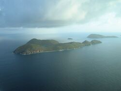
 An aerial view of the Ginger Island and Cooper Island | |
| <mapframe zoom="5" frameless="1" align="center" longitude="-64.47075" latitude="18.392805555556" height="200" width="270">{"type":"Feature","geometry":{"coordinates":[-64.47075,18.392805555555555],"type":"Point"},"properties":{"marker-color":"#5E74F3","title":"Ginger Island","marker-symbol":"lighthouse"}}</mapframe> | |
| Location | Atlantic Ocean 8 kilometres (5.0 mi)southwest of Virgin Gorda |
|---|---|
| Coordinates | [ ⚑ ] 18°23′34.1″N 64°28′14.7″W / 18.392806°N 64.47075°W |
| Constructed | n/a |
| Tower height | 4 metres (13 ft) |
| Focal height | 53 metres (174 ft) |
| Light source | solar power |
| Range | 14 nautical miles (26 km; 16 mi) |
| Admiralty number | J5637 |
| NGA number | 14704 |
| Operator | private[1][2] |
Ginger Island is a presently uninhabited island of the British Virgin Islands in the Caribbean. It is one of the last undeveloped privately held islands in the territory. The island is roughly 258 acres in size. It is the location of two of the better dive sites in the British Virgin Islands: "Alice in Wonderland" and "Ginger Steppes". The island is currently for sale. Most people do not go on the island, as there is no dockage and the island is very overgrown.
See also
- List of lighthouses in the British Virgin Islands
References
- ↑ British Virgin Islands The Lighthouse Directory. University of North Carolina at Chapel Hill. Retrieved 7 September 2016
- ↑ Template:Cite ngall
External links
[ ⚑ ] 18°23′36″N 64°28′40″W / 18.3934°N 64.4778°W

