Earth:Mangapohue Natural Bridge
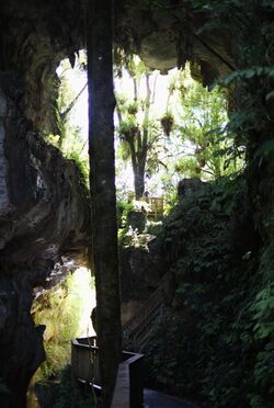
The Mangapohue Natural Bridge consists of two rock arches formed by the Mangapohue Stream in the Marokopa River valley near Waitomo, New Zealand.
The 17 m high limestone arches are a remnant of an ancient cave system.[1] The smaller lower rock arch spans the Mangapohue Stream and cannot be walked through, while the larger upper arch is situated straight above the lower arch and contains a platform to view the stalactites on the upper arch's ceiling.
The arches can be reached by the sealed Te Anga Road from State Highway 3 approximately 25 km west of the Waitomo Caves.[2] From the carpark, the wheelchair-friendly walk takes 5 minutes to reach the natural bridge. The walk leads through a scenic limestone gorge, crossing the stream once on a timber bridge, and ending at a viewing platform below the rock arches. Steps lead to a further viewing platform between the lower and upper arch. A track also continues some 15 minutes further over farmland.[3]
References
- ↑ Mangapohue Natural Bridge - Destination Waikato (from the official tourism website for Waitomo (not-for-profit). Accessed 2014-01-09.)
- ↑ Walks and reserves (from the Waitomo District Council website. Accessed 2014-01-09.)
- ↑ Mangapohue Natural Bridge track (from the New Zealand Department of Conservation website. Accessed 2013-07-20.)
[ ⚑ ] 38°15′37″S 174°54′02″E / 38.26028°S 174.900556°E
 |


