Place:Tari, Papua New Guinea
Tari | |
|---|---|
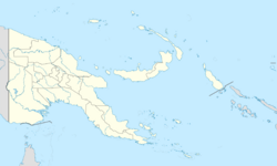
| Coordinates: [ ⚑ ] 5°50′56″S 142°57′2″E / 5.84889°S 142.95056°E | |
| Country | Papua New Guinea |
| Province | Hela |
| LLG | Tari Urban |
| Elevation | 2,167 m (7,110 ft) |
| Population (2013) | |
| • Total | 15,413 |
| • Rank | 19th |
| Languages | |
| • Main languages | English, Tok Pisin, Huli |
| • Traditional language | Huli |
| Time zone | UTC+10 (AEST) |
| Climate | Cfb |
Tari is the capital of the Tari-Pori District and is the centre of Huli country in the Hela Province of Papua New Guinea. It is the second largest settlement in the province, and accessible by road from Mendi. The town is administered under Tari Urban LLG.
Climate
Tari has a subtropical highland climate (Köppen Cfb) with heavy rainfall and mild to warm temperatures year-round. Script error: No such module "weather box".
Aviation accidents
A Cessna 206 aircraft operated by Missionary Aviation Fellowship crashed close to Tari on March 23, 2006, killing its pilot and injuring 3 passengers.[2] The pilot was a 42-year Swiss man who had been in PNG with the Swiss Mission for 12 years, and left a wife and four children behind. The pilot had reportedly entered the circuit area around Tari airfield and appeared to be flying well, but never made it to the runway. The three passengers were PNG nationals.[3]
Gallery
Tari NASA Landsat image
References
- ↑ "Tari Climate (Papua New Guinea)". climate-data.org. https://en.climate-data.org/location/1026832.
- ↑ PAC: Expat pilot killed in PNG light plane crash, AAP News Wire, March 23, 2006
- ↑ PAC: Swiss pilot killed in PNG light plane crash, 3 injured, AAP General News Wire, March 24, 2006
 |


