Place:Witland
From HandWiki
Short description: Historical region in southeast Baltic region inhabited by Prussians
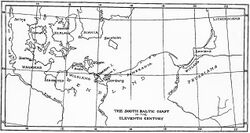
Witland is a seldom-used name for a historical region in the south-east Baltic region inhabited by Prussians (Aestii), called Estum in the text of Wulfstan. The name appears in King Alfred's adapted version of Orosius, in which the traveller Wulfstan's accounts were incorporated.
According to Wulfstan, "the Vistula is a very large river, and near it lie Witland and Weonodland (Wendland); and Witland belongs to the Esthonians."[1]
According to the Anglo-Saxon Chronicle, in 1022, King Canute set sail for Isle of Wight (Old English: Wiht/Wihtlande).[2][3] Some historians argue that the "Wiht/Wihtlande" in this case is actually Witland.[4][5]
References
- ↑ King Alfred's Anglo-Saxon Version of The Compendious History of the World by Orosius, 1859, p.22 & 51.
- ↑ "Manuscript D: Cotton Tiberius B.iv". http://asc.jebbo.co.uk/d/d-L.html.
- ↑ "Manuscript C: Cotton Tiberius C.i". http://asc.jebbo.co.uk/c/c-L.html.
- ↑ Laurence M. Larson: Canute the Great and the Rise of Danish Imperialism during the Viking Age, G. P. Putman's Sons, 1912, p.157-159.
- ↑ John D. Grainger: The British Navy in the Baltic, The Boydell Press, 2014, p.9.
 |


