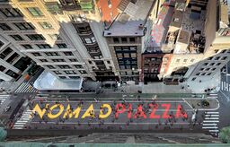
Engineering:NoMad Piazza
[ ⚑ ] 40°44′42″N 73°59′27″W / 40.745°N 73.99083°W
| NoMad Piazza | |
|---|---|
 NoMad PIazza Aerial Shot, August 2021, Manhattan, NYC | |
| Type | Open Streets Pedestrian Venue |
| Location | New York City , New York |
| Coordinates | [ ⚑ ] 40°44′42″N 73°59′27″W / 40.745°N 73.99083°W |
| Created | 2020 |
| Operated by | New York City Department of Transportation |
NoMad Piazza is a pedestrian venue located in New York City on Broadway between 25th and 31st. The area, within Manhattan's NoMad neighborhood, was cordoned off to traffic as part of the NYC Open Streets program, which is run by the NYC DOT, in an effort to allow restaurants to expand outdoor dining as was required for social distancing measures put in place by the city in 2020.[1][2] Parts of the road closure have since become permanent and local businesses have made their move into the streets a salient feature of the area. The St. James and Townsend Buildings reside in the southern block and 31st street serves as the north boundary.[1]
Open Streets and New Urbanism
The Open Streets on Broadway program, of which the Piazza is a part, is managed by the Flatiron/NoMad Partnership and supported by the NoMad Alliance.[3][better source needed] Open streets initiatives existed prior to the pandemic and are cited as an example of New Urbanism's, or sometimes Tactical Urbanism, re-purposing existing areas in metropolitan areas; however, with the need for social distancing, and for businesses to find a way to remain open, areas such as the NoMad Piazza increased substantially in the last three years in a number of cities all over the world.[4]
References
- ↑ 1.0 1.1 Glusac, Elaine (2020-10-29). "How to Staycation in 6 American Cities" (in en-US). The New York Times. ISSN 0362-4331. https://www.nytimes.com/2020/10/29/travel/staycation-nyc-los-angeles.html.
- ↑ "NYC DOT - Open Streets". https://www1.nyc.gov/html/dot/html/pedestrians/openstreets.shtml.
- ↑ "The NoMad Piazza | Broadway Ave between 25th St & 31st St" (in en-US). https://experiencenomad.com/nomad-piazza/.
- ↑ O'Sullivan, Feargus (June 29, 2020). "What Happens to Public Space When Everything Moves Outside". https://www.bloomberg.com/news/features/2020-06-29/what-happens-to-public-space-when-everything-moves-outside.
External links
Community groups and organizations
News and blogs

