Earth:Knivskjellodden
| Knivskjellodden | |
|---|---|
| Knivskjelodden | |
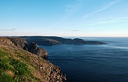
 Knivskjellodden as viewed from the North Cape plateau | |
 | |
| Location | Troms og Finnmark, Norway |
| Coordinates | [ ⚑ ] : 71°11′08″N 25°40′54″E / 71.18556°N 25.68167°E |
| Offshore water bodies | Barents Sea |
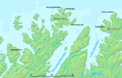
Knivskjellodden or Knivskjelodden is a peninsula located in Nordkapp Municipality in Troms og Finnmark county, Norway . It is the northernmost point on the island of Magerøya in Northern Norway. It is sometimes considered the northernmost point of the entire continent of Europe. The nearby Kinnarodden on the Nordkinn Peninsula is the northernmost point on the mainland.[1] The northernmost point of the country Norway is in fact Rossøya, in Svalbard, as far north as 80°N.
Knivskjellodden can only be reached on foot, after a 9-kilometre (5.6 mi) long hike from a parking area near the European route E69 highway ( [ ⚑ ] 71°07′19″N 25°42′36″E / 71.122°N 25.71°E), 6 km (3.7 mi) south of North Cape. The North Cape tourist facility is located on 300 meter altitude and gives good view in good weather, but is often located above the cloud base, giving fog there. On Knivskjellodden hikers can walk to the shore which is at sea level and at least see the ocean, and usually a view far out below the clouds.
Travel agencies that organize trips for unaware tourists often advertise the North Cape as the northern extremity of Europe, but this is not true as the Knivskjellodden is 1,450 metres (4,760 ft) further north.
See also
- Lindesnes, southernmost point in Norway
- Extreme points of Europe
References
- ↑ Store norske leksikon. "Knivskjelodden" (in Norwegian). http://snl.no/Knivskjelodden. Retrieved 2013-02-13.
External links

