Earth:Central Highlands (Tasmania)
| Central Highlands Tasmania | |||||||||||||||
|---|---|---|---|---|---|---|---|---|---|---|---|---|---|---|---|
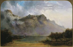
 Mount Olympus depicted by W.C. Piguenit in 1875. | |||||||||||||||
| Script error: No such module "Australian place map". | |||||||||||||||
| Population | 2,141[1] | ||||||||||||||
| LGA(s) | Central Highlands | ||||||||||||||
| State electorate(s) | Lyons | ||||||||||||||
| Federal Division(s) | Lyons | ||||||||||||||
| |||||||||||||||
The Central Highlands is a region in Tasmania, Australia where geographical and administrative boundaries closely coincide. It is also known as The Lake Country of Tasmania.[2]
Geographical region
The mountains of Central Tasmania are mainly found in four different conservation reserves:
- Cradle Mountain-Lake St Clair National Park - in the western part
- Walls of Jerusalem National Park - in the central part
- Central Plateau Conservation Area in the eastern part
Administrative region
The Central Highlands Council incorporates most of the highland region.
Former Hydro communities
Early power developments by Hydro Tasmania in the Central Highlands included the communities of workers who were employed in construction. Significant numbers of the communities were migrants to Australia[3]
The Tarraleah community was one established in 1934 which was a significant early community for the Upper Derwent Power Development. The part of Tarraleah known as Ticklebelly Flat - the area of the married quarters of the community - has become a part of Hydro history, being utilised in the most comprehensive history of the Hydro to date, Heather Fenton's book Ticklebelly Tales.[4]
Fishing
The Central Highlands of Tasmania are home to famous trout fishing lakes and boasts some of the best trout fly fishing found anywhere in the world. The location played host to the 2019 World Fly Fishing Championships. The Central Highlands are on the bucket list for many fly fisherman with popular locations including Great Lake, Arthurs Lake, Woods Lake and Pinestock Lagoon.[5]
Tasmania heartland
The combined councils of the Central Highlands and the two Midlands councils - the southern and the northern have had for almost a decade a web based portal which combines the areas to a name of Tasmanian heartland.[6] The Central Highlands Council has been organising the annual Bushfest which includes various outdoor activities such as fishing, camping, hunting and adventure sports.[7] The event started in 2014 and witnesses a gathering of nearly 4000 people every year.[8]
Lakes
Many lakes are found in the Central Highlands - giving the region the tourist feature of the 'Lakes Region'; they include:
- Arthurs Lake
- Bradys Lake
- Bronte Lagoon
- Great Lake
- Lagoon of Islands
- Lake Augusta
- Lake Binney
- Lake Crescent
- Lake Echo
- Lake King William
- Lake Sorell
- Little Pine Lagoon
See also
- Midlands (Tasmania)
References
- ↑ "Central Highlands (M), 2016 Census QuickStats". https://quickstats.censusdata.abs.gov.au/census_services/getproduct/census/2016/quickstat/LGA61010.
- ↑ Royal Society of Tasmania conducted a symposium at Poatina, 11–12 November 1972 with the symposium of that title: Banks, M.R. (editor) (1973) The Lake Country of Tasmania Hobart, Royal Society of Tasmania - with the Keynote Address by Dr. A.B. Costin Characteristics and Use of Australian High Country - map one p.2 being of interest as it shows relative distribution of Alpine (6000 ft in imperial measurement) and Sub Alpine regions in south east Australia
- ↑ Quirk, Marilyn; Arts Tasmania; Hydro Tasmania (2006), Echoes on the mountain : remarkable migrant stories from the hydro villages of the Tasmanian central highlands, Marilyn Quirk, http://trove.nla.gov.au/work/20443736, retrieved 26 November 2014
- ↑ Felton, Heather; Hydro Tasmania (2008), Ticklebelly tales and other stories from the people of the Hydro, Hydro Tasmania, ISBN 978-0-646-47724-4
- ↑ "Trout Fishing Near Central Highlands Tasmania". https://www.trouttalestasmania.com.au/blog/trout-fishing-near-central-highlands.
- ↑ "Gateway to online information on all aspects of life, including local government, in Tasmania's heartland". A joint initiative of the Northern Midlands, the Southern Midlands, and the Central Highlands Councils. Midlands Initiatives for Local Enterprise Inc.. 2002. http://www.tasmaniacentral.tas.gov.au.
- ↑ "HIGHLANDS BUSHFEST – BOTHWELL RECREATION GROUND". https://centralhighlands.tas.gov.au/bushfest/.
- ↑ "Tasmania to showcase outdoors at Highlands Bushfest". The Examiner. 11 November 2017. https://www.examiner.com.au/story/5047261/tasmania-to-showcase-outdoors-at-highlands-bushfest-2017/.
Further reading
- Cullen, Philip J.(1995) Land degradation on the Central Plateau, Tasmania : the legacy of 170 years of exploitation Hobart, Tas. : Earth Science Section, Parks and Wildlife Service, Dept. of Environment and Land Management. ISBN:0-7246-1930-5 Occasional paper (Tasmania. Parks and Wildlife Service) ; no. 34.
- Jetson, Tim.(1989) The roof of Tasmania: a history of the Central Plateau Launceston, Tas.: Pelion Press. ISBN:0-7316-7214-3
- McKenny, Helen. (2000) A guide to vegetation management issues in the Central Plateau region, Tasmania Hobart, Tas. Dept. of Primary Industries, Water and Environment, ISBN:0-7246-6238-3
[ ⚑ ] 42°12′45″S 146°38′46″E / 42.2124°S 146.646°E
 |


