Earth:Turn-by-turn navigation

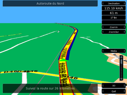
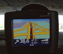
Turn-by-turn Navigation is a feature of some GPS navigation devices where directions for a selected route are continually presented to the user in the form of spoken or visual instructions.[1] The system keeps the user up-to-date about the best route to the destination, and is often updated according to changing factors such as traffic and road conditions.Cite error: Closing </ref> missing for <ref> tag
Mathematically, turn by turn navigation is based on the shortest path problem within graph theory, which examines how to identify the path that best meets some criteria (shortest, cheapest, fastest, etc.) between two points in a large network.
Devices and services
Major mapping services that offer turn-by-turn navigation, grouped by map data provider:[2]
- Nokia.[3] Devices that use HERE Technologies map data:[2]
- Google Maps and Yahoo! Maps.[3] Devices that use Tele Atlas map data:[2]
- TomTom car navigators[3]
- Android smartphones on-line through Google Maps (included as standard)[3]
- Apple iPhone on-line through Google Maps[citation needed]
- OpenStreetMap. Offline-capable applications that use volunteer-contributed data:
- Karta GPS, a navigation app for iOS and Android
- Magic Earth by General Magic, a free navigation app for iOS and Android
- MAPS.ME, a free and open-source app for iOS, Android and BlackBerry OS
- WisePilot by Appello for iOS, Android and BlackBerry OS.
- OsmAnd for Android smartphones[4]
- GPS Navigation & Maps - Scout for Android[5]
- Other:
- Apple Maps using iOS 6 or later
- Apple iPhone using iOS 5 or earlier on-line or offline using various commercial software[6]
- Waze, a free app providing turn-by-turn navigation on iOS, Android, Windows Mobile, Symbian, BlackBerry OS and Windows Phone
- Sygic GPS Navigation, a paid offline turn-by-turn navigation program for iOS and Android
- Genius Maps, a paid offline turn-by-turn navigation program for iOS and Android
History
Real-time turn-by-turn navigation instructions by computer was first developed at the MIT Media Laboratory by James Raymond Davis and Christopher M. Schmandt in 1988.[7] Their system, Backseat Driver, monitored the car's position using a system developed by NEC that communicated over a cellular modem with software running on a Symbolics LISP Machine at the Media Lab. The computer then used a speech synthesizer to compute appropriate directions and spoke them to the driver using a second cellular phone.
References
- ↑ Button, Kenneth J.; David A. Hensher (2001). Handbook of transport systems and traffic control. Emerald Group Publishing. p. 497. ISBN 978-0-08-043595-4. https://books.google.com/books?id=COMbsJ8QqzYC&pg=PA497&dq=turn-by-turn+navigation&hl=en&ei=FXbTTOrzC4SwuAOAl4TWBA&sa=X&oi=book_result&ct=result&resnum=10&ved=0CFsQ6AEwCTgo#v=onepage&q=turn-by-turn%20navigation&f=false.
- ↑ 2.0 2.1 2.2 See comparison of web map services
- ↑ 3.0 3.1 3.2 3.3 3.4 Brady Forrest (14 October 2009). "Google Shrinks Another Market With Free Turn-By-Turn Navigation". O'Reilly Media. http://radar.oreilly.com/2009/10/google-shrinks-another-market.html. Retrieved 4 November 2010.
- ↑ "Osmand Functionality Summary". https://code.google.com/p/osmand/wiki/OsmandFunctionalitySummary. Retrieved 3 September 2014.
- ↑ "GPS Nav & Maps Google play link". https://play.google.com/store/apps/details?id=com.skobbler.forevermapng&hl=en. Retrieved 3 September 2014.
- ↑ "iPhone GPS apps". Navigadget. 29 June 2009. http://www.navigadget.com/index.php/2009/06/29/iphone-gps-apps. Retrieved 7 November 2010.
- ↑ James Raymond Davis; Christopher M. Schmandt (1989). "The Back Seat Driver: Real Time Spoken Driving Instructions". IEEE. https://www.media.mit.edu/speech/papers/1989/davis_VNIS89_backseat_driver.pdf. Retrieved 2019-01-06.


