Place:Suhum
From HandWiki
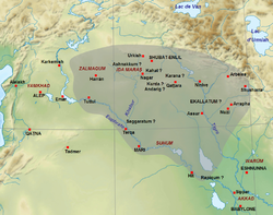
Suhum, Sūḫu, or Suhi[1] was an ancient geographic region around the middle course of the Euphrates River, south of Mari (modern-day Tell Hariri, Syria).
History
Its known history covers the period from the Middle Bronze Age (c. 2000-1700/1600 BCE) to the Iron Age (c. 1200–700 BCE).[2]
Middle Bronze
During the Bronze Age, Suhum was divided into an Upper Suhum, with its capital in Hanat, and a Lower Suhum with its capital in Jabliji. Several ancient letters place the Sutean people as having lived in the region of Suhum.[3]
Iron Age
Neo-Babylonian period
In 616 BCE, Suhum subordinated themselves to the king of Babylon, Nabopolassar (ruled 626-605 BCE). Three years later, in 613 BCE, Suhum rebelled against him, which led Nabopolassar to send an expedition against Suhum.
References
- Citations
- ↑ Russell, H. F. (1985). "The Historical Geography of the Euphrates and Habur According to the Middle- and Neo-Assyrian Sources". Iraq 47: 57–74. doi:10.2307/4200232.
- ↑ Bartelmus, Alexa (2016). "A Short Introduction on the Sūḫu Texts". http://oracc.museum.upenn.edu/suhu/introduction/.
- ↑ Heimpel, Wolfgang (2003). Letters to the King of Mari: A New Translation, with Historical Introduction, Notes, and Commentary. Eisenbrauns. ISBN 9781575060804. p.26
- Bibliography
- Bryce, Trevor (2013). The Routledge Handbook of the Peoples and Places of Ancient Western Asia. Routledge. ISBN 9781134159086., pp. 666-668
 |


