Place:Westside, Gibraltar
Westside | |
|---|---|
City | |
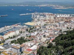
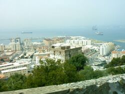
 Westside as seen from the Rock of Gibraltar. | |
| Coordinates: [ ⚑ ] : 36°08′35″N 5°21′17″W / 36.14306°N 5.35472°W | |
| Sovereign state | |
| Overseas Territory | |
| Population (2012) | |
| • Total | 26,572 |
| Time zone | UTC+01:00 (CET) |
| • Summer (DST) | UTC+02:00 (CEST) |
| Postcode areas | GX11 1AA |
Westside is the largest city and de facto capital of Gibraltar. It lies between the western slopes of the Rock of Gibraltar and the eastern shores of the Bay of Gibraltar. In 2012, it was inhabited by 26,572 people and contained 78.15% of the territory's population of 34,000.[1]
Division
The city is divided into six Major Residential Areas. They are: North District, the Reclamation Areas, Sandpits Area, South District, Town Area, and Upper Town.[1]
Geography
A network of narrow streets surround Main Street which runs north–south through the old town. Grand Casemates Square at the northern end of Main Street is the larger of the two main squares within the city centre (the other being John Mackintosh Square). The Governor’s Residence is at the south end of Main Street.
Demographics
| Major Residential Area | Population 2012[1] | Population 2001[2] |
|---|---|---|
| North District | 4,267 | 4,116 |
| Reclamation Areas | 13,356 | 9,599 |
| Sandpits Area | 2,053 | 2,207 |
| South District | 5,681 | 4,257 |
| Town Area | 3,264 | 3,588 |
| Upper Town | 2,457 | 2,805 |
References


