Place:Damanhur
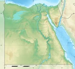
[ ⚑ ] 31°02′10″N 30°28′10″E / 31.03611°N 30.46944°E
Damanhur دمنهور | |
|---|---|
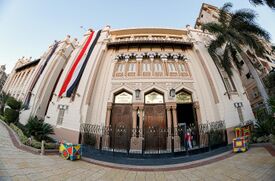
Clockwise from top: Damanhur Opera House, Nasser Mosque, Inside Opera House, Galal Qoraytem square, Damanhur at Night, Damanhur Opera House | |
| Coordinates: [ ⚑ ] 31°02′26″N 30°28′12″E / 31.04056°N 30.47°E | |
| Country | |
| Governorate | Beheira |
| Area | |
| • Total | 6.840 km2 (2.641 sq mi) |
| Elevation | 9 m (30 ft) |
| Population (2021)[1] | |
| • Total | 318,207 |
| • Density | 47,000/km2 (120,000/sq mi) |
| Time zone | UTC+2 (EET) |
| Area code(s) | (+20) 45 |
Damanhur (Arabic: دمنهور Damanhūr, IPA: [dɑmɑnˈhuːɾ]) is a city in Lower Egypt, and the capital of the Beheira Governorate. It is located 160 km (99 mi) northwest of Cairo, and 70 km (43 mi) E.S.E. of Alexandria, in the middle of the western Nile Delta.
Damanhur is a historic city, which history can be dated back to the Old Kingdom of Egypt.[2] The modern city has also absorbed the ancient villages Shubra al-Jadida (Arabic: شبرا الجديدة, Coptic: ϫⲉⲃⲣⲟ ⲙⲃⲉⲣⲓ), Tāmus (Arabic: طاموس), Askanida (Arabic: اسكنيدة) and Chortaso (Arabic: قرطسا, Ancient Greek:).[3][4][5]
Etymology
| <hiero>D46-W19-M17-M17-O49-W24-G5-Z1</hiero>or<hiero>D46:Aa15-W19-M17-M17-X1:O49-S3-G6-X1:O49</hiero> |
| Țemāi en Ḥeru[6] in hieroglyphs |
|---|
The city's modern Arabic name comes from Coptic p-Timinhor (Coptic: ⲡϯⲙⲓⲛ̀ϩⲱⲣ, Template:IPA-cop), which in turn is derived from Ancient Egyptian: pꜣ-dmỉ-n-Ḥr.w, lit. 'the settlement of Horus', also attested in Aramaic (Aramaic: תמנחור, romanized: Temenkhūr).[2]
The Greeks called the city Hermopolis Mikra (Ancient Greek:).[7]
The name of the city suggests that Horus, whom Greeks equated with Apollo, was worshipped as the chief deity. However, the Greek name for the town, Hermopolis Mikra, suggests that Hermes/Thoth was the local god. This discrepancy is possibly due to a misinterpretation that persisted even after the Greeks had gained a better understanding of Egypt.[8]
History
In ancient Egypt, the city was the capital of Lower Egypt's 7th Nome of A-ment. It stood on the banks of a canal which connected the lake Mareotis with the Canopic or most westerly arm of the Nile.[9]
The city attracted the notice of numerous ancient geographers, including Stephanus of Byzantium s. v., Strabo (xvii. p. 802), Ptolemy (iv. 5. § 46), and the author of the Antonine Itinerary (p. 154). It is a Roman Catholic titular see.
It was first made a provincial capital under Fatimid rule in 11th century, and in the Middle Ages it prospered as a caravan town on the post road from Cairo to Alexandria. It was severely damaged in 1302 by an earthquake, but in the late 14th century the Mamluk caliph Barquq restored its fortifications to protect the city from Bedouins.
In 1799, the city revolted against the French, who cruelly crushed the rebels, killing 1,500.
In 1986, the population of Damanhur was 188,939. The richly cultivated Beheira province gives rise to mainly agricultural industries which include cotton ginning, potato processing, and date picking. It also has a market for cotton and rice.
On the 10th of February 2023 six people, including three boys, were killed and at least 20 injured when an apartment building collapsed.[10]
Notable people
- Cyril VI
- Ahmed H. Zewail
Climate
Being located close to the Nile Delta and the northern coast of Egypt, that give Damanhur a hot desert climate (Köppen: BWh), moderated by blowing winds coming from the Mediterranean Sea, typical to the coast. The city gets average precipitation during winter, and rare rain during other seasons. Hail and frost are not unknown specifically during winter.
Script error: No such module "weather box".
References
- ↑ 1.0 1.1 "Damanhūr (Kism (fully urban), Egypt) - Population Statistics, Charts, Map and Location". https://citypopulation.de/en/egypt/admin/al_bu%E1%B8%A5ayrah/1801__damanh%C5%ABr/.
- ↑ 2.0 2.1 Peust, Carsten. "Die Toponyme vorarabischen Ursprungs im modernen Ägypten". p. 33. http://www.peust.de/ortsnamen_original.pdf.
- ↑ "Carte geographique de l'Egypte et des pays environnans by Pierre Jacotin". 1818. https://atlas.paths-erc.eu/map/saved/all_ms_places.[yes|permanent dead link|dead link}}]
- ↑ Stefan, Timm (1988). Das christlich-koptische Agypten in arabischer Zeit. pp. 884–885.
- ↑ "TM Places". https://www.trismegistos.org/place/8064.
- ↑ Wallis Budge, E. A. (1920). An Egyptian hieroglyphic dictionary: with an index of English words, king list and geological list with indexes, list of hieroglyphic characters, coptic and semitic alphabets, etc. Vol II. John Murray. p. 1062. https://archive.org/details/egyptianhierogly02budguoft.
- ↑ Bernand, A. (2021-12-13). "Hermopolis Mikra: a Pleiades place resource" (in en). https://pleiades.stoa.org/places/727123.
- ↑ "Damanhūr". Encyclopædia Britannica. 7 (11th ed.). 1911. p. 783.
- ↑ Champollion, L'Egypte, vol. ii. p. 249
- ↑ Hendawi, Hamza (2023-02-10). "Three boys among six killed in building collapse north of Cairo" (in en). https://www.thenationalnews.com/mena/2023/02/10/boy-of-10-among-four-killed-in-building-collapse-north-of-cairo/.
- ↑ "Climate: Damanhur - Climate graph, Temperature graph, Climate table". Climate-Data.org. http://en.climate-data.org/location/3675/.
External links
- Falling Rain Genomics, Inc. "Geographical information on Damanhur, Egypt". http://www.fallingrain.com/world/EG/3/Damanhur.html.
- https://www.facebook.com/Egy.Dam Official Facebook page for the city
- https://web.archive.org/web/20051107230115/http://www.damanhour.5u.com/en.htm English script
- https://web.archive.org/web/20080321235728/http://www.saeednet.4t.com/ live cam from damanhour
 S. Pétridès (1913). "Hermopolis Parva". in Herbermann, Charles. Catholic Encyclopedia. New York: Robert Appleton Company.
 |


