Engineering:Pytchair
| Pytchair | |
|---|---|

| |
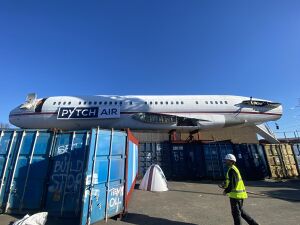
| PYTCHAir resting on containers | |
| Type | Boeing 727-46 |
| Manufacturer | Boeing |
| Construction number | 19282/495[1] |
| Manufactured | 1967 |
| Registration |
|
| First flight | 13 November 1967 |
| Owners and operators |
|
| In service | 1967 - 2015 |
| Fate | Broken up in 2015; fuselage preserved |
| Preserved at | Bonville Road, Brislington |
PYTCHAir is the name given to a Boeing 727 located in the Brislington area of Bristol. The aircraft was originally a Japan Airlines passenger aircraft which first flew in 1968. It was converted into a private jet and operated by various owners including LarMag Aviation.[2]
It was purchased in 2020 to be used as an office. The relocation was delayed until February 2021, when it was transported by road to Bonville Road, Brislington.[3] (As of November 2021), the fuselage is on display and used as an office, filming location and is available for charity events.[4] It has been featured as a “quirky" and "cool" office.[5][6]
In March 2022 the fuselage was covered in street art by Bristol street artsists Harriet Wood, Curtis Hylton and Hasan Kamil.[7] The art work drew media attention.[8]
Gallery
References
- ↑ "VP-CNM". https://rzjets.net/aircraft/?reg=43903. Retrieved 12 September 2022.
- ↑ "Registration Details for VP-CMN (IDG) 727-46 - PlaneLogger". https://www.planelogger.com/Aircraft/Registration/VP-CMN/496460.
- ↑ "Bristol motorway journey for huge Boeing jet". BBC News. 27 February 2021. https://www.bbc.co.uk/news/uk-england-gloucestershire-56222067.
- ↑ "PYTCHAir (Boeing 727)" (in en-US). 2021-08-02. https://bristolopendoors.org.uk/events/pytchair-boeing-727/.
- ↑ Finch, Hannah (2022-04-08). "Nine of the UK's quirkiest offices from a jumbo jet, DJ booths to a dance floor" (in en). https://www.business-live.co.uk/commercial-property/nine-uks-quirkiest-offices-converted-23589409.
- ↑ Turton, Tora (2023-02-01). "The UK's 10 coolest offices of 2023" (in en-GB). https://www.adzuna.co.uk/blog/coolest-offices-in-the-uk/.
- ↑ "Boeing 727 plane in Bristol transformed after paint job". 25 March 2022. https://www.business-live.co.uk/commercial-property/boeing-727-plane-bristol-transformed-23496794.
- ↑ "Boeing 727 that travelled along M5 transformed". 25 March 2022. https://www.bristolpost.co.uk/news/bristol-news/boeing-727-travelled-along-m5-6858689.
Further reading
- Inside the Midwich-equipped PYTCHAir private jet, August 31, 2021, https://www.avinteractive.com/news/collaboration/inside-midwich-equipped-pytchair-private-jet-31-08-2021/, retrieved 23 May 2023
- "Boeing 727 to be transported down M5 and M4". 12 February 2021. https://www.business-live.co.uk/commercial-property/boeing-727-travel-down-m5-19822760.
- "Former private jet to become unique office and meetings space". 4 November 2020. https://www.bristol247.com/news-and-features/news/former-private-jet-to-become-unique-office-and-meetings-space/.
- "Delay in Turning Former Japan Airlines Boeing 727 into Office Space". 29 January 2021. https://simpleflying.com/japan-airlines-boeing-727-office-delay/.
- "Bristol entrepreneur purchases Boeing 727 from Cotswold Airport for office expansion". 10 February 2021. https://www.freshaviation.co.uk/bristol-entrepreneur-purchases-boeing-727-from-cotswold-airport-for-office-expansion/.
- "Boeing 727 'stuck in the mud' at Cotswold Airport". 29 January 2021. https://www.itv.com/news/westcountry/2021-01-29/boeing-727-stuck-in-the-mud-at-cotswold-airport.
- "Bristol motorway journey for huge Boeing jet". BBC News. 27 February 2021. https://www.bbc.co.uk/news/uk-england-gloucestershire-56222067.
- "Here's a Cut-Up Boeing 727 Slowly Crawling Down the Motorway to its New Home". 2 March 2021. https://www.autoevolution.com/news/heres-a-cut-up-boeing-727-slowly-crawling-down-the-motorway-to-its-new-home-157026.html#.
External links
[ ⚑ ] 51°26′11″N 2°32′10″W / 51.43625°N 2.53621°W
 |


