Place:Garoua
Garoua | |
|---|---|
City | |
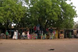
 The Market at Garoua | |
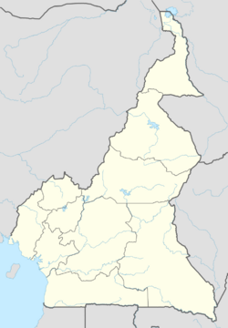
| Coordinates: [ ⚑ ] 9°18′N 13°24′E / 9.3°N 13.4°E | |
| Country | |
| Region | North |
| Department | Bénoué |
| Elevation | 249 m (817 ft) |
| Population (2023) | |
| • Total | 2,000,000 |
| Climate | Aw |
Garoua (also Garua; Fula: 𞤺𞤢𞤪𞤱𞤢, Garwa) is a port city and the capital of the North Region of Cameroon, lying on the Benue River. A thriving centre of the textiles and cotton industries, the city has approximately 1,285,000 inhabitants in 2020, mostly Fulbe/Fulani people.[1]
History
Garoua was established by the Fulani emir Modibbo Adama in the first half of the 19th century. During the steamship era, it developed into a major river port.[2]
The population of the city was 30,000 in 1967.[3]
Geography
Garoua is situated in northern Cameroon, and lies on the Benue River.[4] It serves as the gateway to Benoue National Park.[5] Neighborhoods include Commercial Centre, Lopere, Quartier de Marouare, Poumpoumre, Roumde Adjia and the northwestern suburb of Yelwa, near Garoua International Airport.[4]
Climate
Garoua has a tropical savanna climate (Köppen Aw), with a wet season and a dry season and the temperature being hot year-round. The average temperature in Garoua ranges from 26.0 °C (78.8 °F) in December and January, the coolest months, to 33.0 °C (91.4 °F) in April, the hottest month. The hottest time of year is in March and April, just before the wet season starts. March has the highest average high at 39.8 °C (103.6 °F), while the highest average low is 26.4 °C (79.5 °F) in April. August has the lowest average high at 30.7 °C (87.3 °F), while December has the lowest average low at 17.3 °C (63.1 °F).
Garoua receives 997.4 millimetres (39.27 in) of rain over 88 precipitation days, with a distinct wet and dry season like most tropical savanna climates. December, January and February receive no precipitation at all. August, the wettest month, receives 247.9 millimetres (9.76 in) of rainfall on average. September has 24 precipitation days, which is the most of any month. Garoua receives 2927.1 hours of sunshine annually on average, with the sunshine being distributed evenly across the year, although it is lower during the wet season.
Script error: No such module "weather box".
Demographics
In 2005, Garoua had a population of 495,996 people. The city is inhabited by the Fulbe ethnic group.[7] Due to a significant number of Chadian expatriates in the city, there is a Chadian Consulate.[5]
Economy
As the fourth largest port in Cameroon,[8] Garoua is a major center of trade in the country.[9] It developed as a centre for trade in petroleum, cement, hides, peanuts, and cotton, transported on ships along the Benue River, between Burutu in Nigeria.[2] It has long been a thriving centre of the cotton industry and houses several textile processing facilities and factories.[10] The cotton company Sodecoton has one of its major centres in the city.[11] Leatherwork and fishing are also notable industries.[2]
Sport
Roumdé Adjia Stadium is set to be one of the arenas hosting the 2021 Africa Cup of Nations.
Places of worship
Among the places of worship, there are, predominantly, Muslim mosques. There are also Christian churches and temples: Roman Catholic Archdiocese of Garoua (Catholic Church), Evangelical Church of Cameroon (World Communion of Reformed Churches), Presbyterian Church in Cameroon (World Communion of Reformed Churches), Cameroon Baptist Convention (Baptist World Alliance), Full Gospel Mission Cameroon (Assemblies of God).[12]
Transport
Garoua is served by Garoua International Airport. [13] The United States military uses the airport as a base to conduct unmanned aerial vehicle operations.[14] The city lies on National Highway 1,[4] at a junction of the road between Maroua and Ngaoundéré.[2] The main road leading north through the town and past the airport is called Rue de la Gendarmerie.[4]
Notable people
- Goggo Addi (1911–1999), storyteller who worked to preserve Fulani cultural heritage[15]
- Ahmadou Ahidjo (1924–1989), first president of Cameroon[16]
- Youssoufa Daoua (in French) (1947-2015), politician
- Gautier Bello (born 1983), footballer
- Vincent Aboubakar (born 1992), professional footballer
References
- ↑ "Population of Cities in Cameroon (2018)". http://worldpopulationreview.com/countries/cameroon-population/cities/.
- ↑ 2.0 2.1 2.2 2.3 "Garoua". Encyclopædia Britannica. https://www.britannica.com/place/Garoua. Retrieved 29 October 2016.
- ↑ Mark Dike DeLancey, Rebecca Neh Mbuh, Mark W. Delancey, Historical Dictionary of the Republic of Cameroon, Scarecrow Press, USA, 2010, p. 189
- ↑ 4.0 4.1 4.2 4.3 Google (29 October 2016). "Garoua" (Map). Google. Retrieved 29 October 2016. Missing or empty
|title=(help) - ↑ 5.0 5.1 Ham, Anthony (2009). West Africa. Lonely Planet. p. 207. ISBN 978-1-74104-821-6. https://books.google.com/books?id=1HapewBo3c0C&pg=PA207.
- ↑ "Garoua Climate Normals 1961–1990". National Oceanic and Atmospheric Administration. ftp://ftp.atdd.noaa.gov/pub/GCOS/WMO-Normals/TABLES/REG__I/KM/64860.TXT.
- ↑ Drønen, Tomas Sundnes (31 August 2009). Communication and Conversion in Northern Cameroon: The Dii People and Norwegian Missionaries, 1934-1960. BRILL. p. 40. ISBN 978-90-474-3098-8. https://books.google.com/books?id=PT-xCQAAQBAJ&pg=PA40.
- ↑ Trillo, Richard (2 June 2008). The Rough Guide to West Africa. Rough Guides Limited. p. 3028. ISBN 978-1-4053-8068-3. https://books.google.com/books?id=clU65BAfOmUC&pg=PT3028.
- ↑ Georgia (Republic) Export-Import Trade and Business Directory. International Business Publications. October 2005. p. 97. ISBN 978-0-7397-3267-0. https://books.google.com/books?id=qlArJ3yV4rUC&pg=PA97.
- ↑ Ndenecho, Emmanuel Neba (2011). Decentralisation and Spatial Rural Development Planning in Cameroon. African Books Collective. p. 76. ISBN 978-9956-717-66-8. https://books.google.com/books?id=6KkL0YxFxPsC&pg=PA76.
- ↑ Raimond, Christine (8 October 2013). Ressources vivrières et choix alimentaires dans le bassin du lac Tchad. IRD Editions. p. 202. ISBN 978-2-7099-1576-2. https://books.google.com/books?id=-B4VObZQ11gC&pg=PA202.
- ↑ J. Gordon Melton, Martin Baumann, ‘‘Religions of the World: A Comprehensive Encyclopedia of Beliefs and Practices’’, ABC-CLIO, USA, 2010, p. 484-486
- ↑ Africa Review 2003/04: The Economic and Business Report. Kogan Page Publishers. 2003. p. 44. ISBN 978-0-7494-4065-7. https://books.google.com/books?id=nDSR1FF2hY8C&pg=PA44.
- ↑ Hammer, Joshua (2016-02-25). "Hunting Boko Haram: The U.S. Extends Its Drone War Deeper Into Africa With Secretive Base". The Intercept. https://theintercept.com/2016/02/25/us-extends-drone-war-deeper-into-africa-with-secretive-base/.
- ↑ Baumgardt, Ursula (2000). Une conteuse peule et son répertoire : Goggo Addi de Garoua, Cameroun : textes et analyses. Goggo Addi. Paris: Karthala. ISBN 2-84586-104-4. OCLC 45647204. https://www.worldcat.org/oclc/45647204.
- ↑ Appiah, Anthony; Gates, Henry Louis (2010). Encyclopedia of Africa. Oxford University Press. p. 73. ISBN 978-0-19-533770-9. https://books.google.com/books?id=A0XNvklcqbwC&pg=PA73.
External links
[ ⚑ ] 09°18′N 13°24′E / 9.3°N 13.4°E
 |


