Earth:San Andreas Fault Observatory at Depth
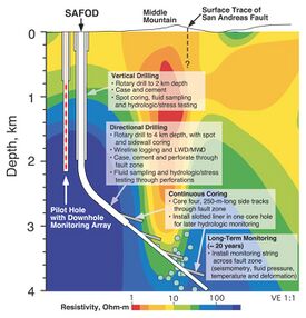
 Schematic representation of the SAFOD borehole and pilot hole | |
| Location | |
|---|---|
| Location | Parkfield, California, U.S. |
| Coordinates | [ ⚑ ] : 35°58′27″N 120°33′08″W / 35.974204°N 120.552141°W |
| Greatest depth | 3.2 km (2 miles) |
| History | |
| Opened | 2002 |
| Owner | |
| Company | National Science Foundation |
| Website | www |
The San Andreas Fault Observatory at Depth (SAFOD) is a research project that began in 2002 aimed at collecting geological data about the San Andreas Fault for the purpose of predicting and analyzing future earthquakes.[1][2] The site consists of a 2.2 km (1.4 miles) pilot hole and a 3.2 km (2 miles) main hole.[3] Drilling operations ceased in 2007. Located near the town of Parkfield, California, the project has installed geophone sensors and GPS clocks in a borehole that cuts directly through the fault.[3] This data, along with samples collected during drilling, could shed new light on geochemical and mechanical properties around the fault zone.
SAFOD is part of Earthscope, an Earth science program using geological and geophysical techniques to explore the structure of the North American continent and to understand the origin of earthquakes and volcanoes. Earthscope is funded by the National Science Foundation in conjunction with the U.S. Geological Survey and NASA.[4] Data collected at SAFOD are available from The Northern California Earthquake Data Center at U.C. Berkeley and at the IRIS DMC.
See also
- Chikyū Hakken, deep oceanic drilling program
- Integrated Ocean Drilling Program
- Kola Borehole (1970–2005, 12,262 m or 40,230 feet)
- KTB Borehole (1987–1995, 9,101 m or 29,859 feet)
- Mohorovičić discontinuity
- Project Mohole
References
- ↑ Shiels, Maggie (December 5, 2003). "Project to drill into Earth fault". BBC News. http://news.bbc.co.uk/2/hi/science/nature/3293947.stm. Retrieved September 4, 2018.
- ↑ Shwartz, Mark (December 3, 2003). "Stanford, U.S. Geological Survey team up to get inside scoop on quake zone San Andreas Fault Observatory at Depth will permit researchers to collect temblor data 2.4 miles below surface of Earth". Stanford News. https://news.stanford.edu/news/2003/december3/safod-123.html. Retrieved September 4, 2018.
- ↑ 3.0 3.1 "SAFOD (San Andreas Fault Observatory at Depth)". Northern California Earthquake Data Center. http://www.quake.geo.berkeley.edu/safod/. Retrieved September 4, 2018.
- ↑ "San Andreas Fault Observatory at Depth". U.S. Geological Survey. https://earthquake.usgs.gov/research/parkfield/safod_pbo.php. Retrieved September 4, 2018.
Further reading
- Ellsworth, W. L.; S. H. Hickman; M. D. Zoback (January 1, 2000). "Seismology in the Source: The San Andreas Fault Observatory at Depth". Seismol. Res. Lett. 71.
- Ellsworth, W.; S. Hickman; M. Zoback; E. Davis; L. Gee; R. Huggins; R. Krug; C. Lippus et al. (2005). "Observing the San Andreas Fault at depth". Eos, Transactions, American Geophysical Union 86: 52. Bibcode: 2005AGUFM.T24B..04E.
- Zoback, M. D (1998). "Scientific drilling into the San Andreas fault and site characterization research: Planning and coordination efforts. Final technical report".
- Zoback, M.D.; S.H. Hickman; W. Ellsworth (2002). "The San Andreas Fault Observatory at Depth (SAFOD): testing fundamental theories of earthquake mechanics". 2002 Denver Annual Meeting.
- Zoback, M. (2003). "Scientific Drilling into the San Andreas Fault: The SAFOD Experiment". AAPG Annual Meeting 2003.
- Zoback, M.D.; S. Hickman; W. Ellsworth (2005). "Overview of SAFOD Phases 1 and 2: Drilling, sampling and measurements in the San Andreas Fault zone at seismogenic depth". Eos, Transactions, American Geophysical Union 86 (5): 52. doi:10.1029/2005EO050006. Bibcode: 2005EOSTr..86...52H.
- Zoback, M.D.; S.H. Hickman; W. Ellsworth; D. Kirschner; N.B. Pennell; J. Chery; S. Sobolev (2007). "Preliminary Results from SAFOD Phase 3: Implications for the state of stress and shear localization in and near the San Andreas Fault at depth in central California". American Geophysical Union, Fall Meeting 2007, abstract# T13G-03.
- Zoback, Mark D.; Hans-Peter Harjes (1997). "Injection-induced earthquakes and crustal stress at 9 km depth at the KTB deep drilling site, Germany". Journal of Geophysical Research 102 (B8): 18477–18491. doi:10.1029/96JB02814. Bibcode: 1997JGR...10218477Z. http://www.agu.org/pubs/crossref/1997.../96JB02814.shtml. Retrieved March 28, 2009.
- EarthScope (2008). "EarthScope: SAFOD Observatory". EarthScope. http://www.earthscope.org/observatories/safod. Retrieved March 28, 2009.
- Emmermann, Rolf; Rischmüller, Heinrich (October 31, 2006). "ICDP – International Continental Scientific Drilling Program". German Continental Scientific Deep Drilling Program. GFZ German Research Centre for Geosciences, Telegrafenberg, D-14473 Potsdam, Germany. http://www.icdp-online.org/contenido/icdp/front_content.php?idcat=946. Retrieved March 28, 2009.
- "KTB Deep Crustal Laboratory of GFZ". 2006. Archived from the original on April 15, 2013. https://archive.today/20130415020241/http://www.icdp-online.org/sites/ktbto/references/ktbtopubs.htm. Retrieved March 28, 2009.
- USGS; NSF (January 29, 2009). "San Andreas Fault Observatory at Depth". https://earthquake.usgs.gov/research/parkfield/safod_pbo.php. Retrieved March 28, 2009.
External links
- Earthscope
- SAFOD at ICDP-Online.org
 |

