Earth:Mount Batok
| Mount Batok | |
|---|---|
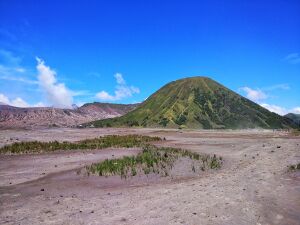
 View of Mount Batok and Bromo crater from Tengger sandsea | |
| Highest point | |
| Elevation | 2,440 m (8,005 ft) [1] |
| Prominence | 340 m (1,115 ft) [2] |
| Listing | Spesial Ribu |
| Coordinates | [ ⚑ ] : 7°56′05.2″S 112°56′50.4″E / 7.934778°S 112.947333°E |
| Naming | |
| Etymology | Coconut Shell (in Javanese) |
| Geography | |
| Geology | |
| Mountain type | Cinder cone |
Mount Batok is a cinder cone located in East Java, Indonesia. This volcano has an elevation of 2,440 metres (8,005 ft) above sea level, and is located between four regencies: Probolinggo Regency, Pasuruan Regency, Lumajang Regency, and Malang Regency. The location of Mount Batok is west from Mount Bromo. This mountain is one of the inactive volcanoes located within the Tengger caldera. Mount Batok is part of Bromo Tengger Semeru National Park.
Mount Batok is often misidentified as the nearby Mount Bromo due to its prominence in the caldera, and its position in front of the more flat Bromo crater as viewed from their most popular viewpoints along the northern rim.[3][4]
Etymology
In Javanese, batok means "coconut shell". The Tenggerese people believe that Mount Batok was formed from a coconut shell which was kicked by Resi Bima, a powerful giant, after failing to fulfill the conditions proposed by Rara Anteng to marry her.
See also
| Wikivoyage has a travel guide for Bromo-Tengger-Semeru National Park. |
- Mount Bromo
- Bromo Tengger Semeru National Park
- Volcanology of Java
- List of volcanoes in Indonesia
References
- ↑ "Tengger Caldera". Smithsonian Institution. https://volcano.si.edu/volcano.cfm?vn=263310.
- ↑ "Tengger Caldera" (in id). http://www.vsi.esdm.go.id/index.php/gunungapi/data-dasar-gunungapi/532-g-bromo.
- ↑ "Riding Mt. Bromo". 2013-06-10. http://adventurenomad.blogspot.com/2013/06/riding-mt-bromo.html.
- ↑ "The folded mountains of East Java". 2016-12-09. https://bdbackpacker.wordpress.com/2016/12/09/the-folded-mountains-of-east-java/.
External links
 |


