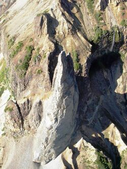
Earth:The Monument (British Columbia)
The Monument is a hoodoo in Cassiar Land District of the Northern Interior of British Columbia, Canada.[1] It lies on the southwestern side of Hoodoo Mountain, a flat-topped stratovolcano in the Northern Cordilleran Volcanic Province.[2] This light grey, needle-like rock formation has an elevation of about 1,100 m (3,600 ft) and rises more than 100 m (330 ft) high, gradually decreasing in diameter to a very sharp point.[1][2] It is slightly oval in cross-section and stands out against the volcanic rocks comprising Hoodoo Mountain.[1]
The Monument contains horizontal columnar jointing and is the eroded remains of a volcanic vent that was probably active between 40,000–30,000 years ago.[1][2][3] However, the amount of lava supplied by The Monument was probably small compared to the main vents now buried beneath Hoodoo's ice cap.[1] It was fed by a dike that intrudes Slide Canyon on the southwestern side of Hoodoo Mountain.[2][3] The surface of The Monument peels off like the layers of an onion, resulting in the creation of a light grey talus deposit at its base.[1][2] The Monument has been described as a lava spine or a volcanic neck.[1][3]
The Monument is a local name that has not been officially approved by the Geographical Names Board of Canada.[1][3]
References
- ↑ 1.0 1.1 1.2 1.3 1.4 1.5 1.6 1.7 Kerr, F. A. (1948). Lower Stikine and western Iskut river areas, British Columbia (Report). Canada Department of Mines. pp. 44, 45. doi:10.4095/101626.
- ↑ 2.0 2.1 2.2 2.3 2.4 "Hoodoo Mountain, NW British Columbia, Canada". Oregon State University. http://volcano.oregonstate.edu/vwdocs/volc_images/north_america/canada/Final-Hoodoo.html.
- ↑ 3.0 3.1 3.2 3.3 Ralph Edwards, Benjamin (1997). Field, Kinetic, and Thermodynamic Studies of Magmatic Assimilation in the Northern Cordilleran Volcanic Province, Northwestern British Columbia (PhD). University of British Columbia. pp. 48, 54.
[ ⚑ ] 56°45′49″N 131°19′37″W / 56.76361°N 131.32694°W
 |


