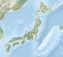
Earth:Numazawa (volcano)
From HandWiki
| Numazawa | |
|---|---|
 Lake Numazawa | |
| Highest point | |
| Elevation | 2,740 ft (840 m) |
| Listing | Volcanoes in Japan |
| Coordinates | [ ⚑ ] : 38°57′40″N 140°47′17″E / 38.961°N 140.788°E |
| Geography | |
| Geology | |
| Mountain type | Shield volcano |
| Last eruption | 3,400 BCE |
Numazawa is a caldera and lake in Ōnuma District of Fukushima Prefecture, Japan. The caldera measures 2 km (1.2 mi) across and the lake that occupies it measures 96 m (315 ft) deep. The volcanic caldera was constructed within the older and larger Uwaigusa caldera which is 4.2 to 4.0 million years old.[1] The volcano first erupted 110,000 years before present (BP) produced pyroclastics. At 71,000 BP, the Mukuresawa lava dome formed, and at 45,000 BP, a Plinian eruption occurred. Two additional lava domes developed in 43,000 BP and 20,000 BP. The caldera-forming Plinian eruption eruption occurred at 4,600 BP. A VEI 5 eruption occurred at 3,400 BP.[2]
See also
- List of volcanoes in Japan
- List of mountains in Japan
References
- ↑ Yamamoto, Takahiro (2007). "A rhyolite to dacite sequence of volcanism directly from the heated lower crust: Late Pleistocene to Holocene Numazawa volcano, NE Japan". Journal of Volcanology and Geothermal Research 167 (1-4): 119–133. doi:10.1016/j.jvolgeores.2007.05.011.
- ↑ "Numazawa". Smithsonian Institution. https://volcano.si.edu/volcano.cfm?vnum=283151.
 |


