Earth:Caldera del Atuel
From HandWiki
Short description: Mountain in Argentina
| Caldera del Atuel | |
|---|---|
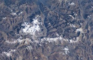
 A complex of snow-covered cones (left-center) partially fills the 30 x 45 km wide Caldera del Atuel, which lies just east of the Argentina-Chile border. The headwaters of the Río del Atuel drain to the SE through a wide breach in the caldera rim (top center) in this NASA International Space Station image (with north to the bottom left). The snow-covered Volcán Overo and Sosneado complexes in the eastern part of the caldera contain numerous very youthful basaltic-to-andesitic pyroclastic cones and lava flows. | |
| Highest point | |
| Elevation | 5,189 m (17,024 ft) |
| Coordinates | [ ⚑ ] 34°39′S 70°03′W / 34.65°S 70.05°W |
| Geography | |
| Location | Mendoza Province, Argentina |
| Parent range | Andes |
| Geology | |
| Mountain type | Caldera |
| Last eruption | Unknown |
Caldera del Atuel is a caldera in Argentina . It is the source of the Rio Atuel and has dimensions of 30 by 45 kilometres (19 mi × 28 mi). Cerro Sosneado is a volcano (best volume estimate 244.2 cubic kilometres (58.6 cu mi)) located outside of the Atuel caldera, Volcan Overo (best volume estimate 89 cubic kilometres (21 cu mi)) and Las Lágrimas complex are located within the caldera.[1][2] Holocene activity may have formed the cinder cones on the northeastern side of the caldera.[3] After the 2010 Maule earthquake, the caldera was one of the volcanic centres that underwent subsidence,[4] along with secondary earthquake activity.[5]
See also
- List of volcanoes in Argentina
References
- ↑ Völker, David; Kutterolf, Steffen; Wehrmann, Heidi (August 2011). "Comparative mass balance of volcanic edifices at the southern volcanic zone of the Andes between 33°S and 46°S". Journal of Volcanology and Geothermal Research 205 (3–4): 114–129. doi:10.1016/j.jvolgeores.2011.03.011. Bibcode: 2011JVGR..205..114V.
- ↑ "Volcanes Activos" (in es). Instituto Geográfico Nacional (Argentina). http://www.ign.gob.ar/descargas/geografia/volcanes_activos.pdf. Retrieved 28 January 2016.
- ↑ Perucca, Laura P.; Moreiras, Stella M. (2009). "Seismic and Volcanic Hazards in Argentina". Natural Hazards and Human-Exacerbated Disasters in Latin America. Developments in Earth Surface Processes. 13. pp. 267–300. doi:10.1016/S0928-2025(08)10014-1. ISBN 9780444531179.
- ↑ Jay, Jennifer; Pritchard, Matthew. "The Andean Southern Volcanic Zone: Deformation, Eruptions, and Thermal Anomalies Before and After t he 2010 Mw 8.8 Maule Earthquake". SERNAGEOMIN. Archived from the original on 28 January 2016. https://web.archive.org/web/20160128105929/http://biblioteca.sernageomin.cl/opac/DataFiles/14127_pp_477_479.pdf. Retrieved 28 January 2016.
- ↑ Scott, Chelsea; Lohman, Rowena; Pritchard, Matthew; Alvarado, Patricia; Sánchez, Gerado (March 2014). "Andean earthquakes triggered by the 2010 Maule, Chile (Mw 8.8) earthquake: Comparisons of geodetic, seismic and geologic constraints". Journal of South American Earth Sciences 50: 27–39. doi:10.1016/j.jsames.2013.12.001. Bibcode: 2014JSAES..50...27S.
 |

