Earth:Bateti Lake
From HandWiki
Short description: Lake in Georgia
| Bateti Lake | |
|---|---|
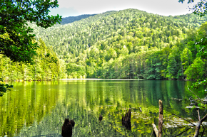
 Bateti lake in Fall | |
| Coordinates | [ ⚑ ] : 41°53′46″N 43°46′06″E / 41.89611°N 43.76833°E |
| Native name | ბატეთის ტბა (Georgian) |
| rivers, streams, evaporation">Primary outflows | spring |
| Catchment area | 5 km2 (1.9 sq mi) |
| Basin countries | Georgia |
| Surface area | 0.02 km2 (0.0077 sq mi) |
| Average depth | 7 m (23 ft) |
| Max. depth | 12 m (39 ft) |
| Water volume | 0.14 km3 (0.034 cu mi) |
| Surface elevation | 1,313 m (4,308 ft) |
| Lua error in Module:Mapframe at line 384: attempt to perform arithmetic on local 'lat_d' (a nil value). | |
Bateti Lake (Georgian: ბატეთის ტბა) is a landslide lake on Batetistskali River located near village Kodmani in the valley of Dzama river, Kareli Municipality, in Shida Kartli region of Georgia, at 1313 metres above sea level.[1] The water area of the lake is only 0.02 km2. Maximal depth is 12 meters.[2][3]
Fauna
Lake is habitat of near-threatened species of newt (Ommatotriton ophryticus).
Photo gallery
References
- ↑ Monasteries of Dzama Gorge and Bateti Lake Georgiantour.com
- ↑ Georgian Soviet Encyclopedia I. Apkhazava, V. 2, p. 228, 1977
- ↑ Bateti Lake in Winter vs. in Autumn Georgia Journal
 |


