Earth:Trölladyngja
| Trölladyngja | |
|---|---|
 | |
| Highest point | |
| Elevation | 1,468 m (4,816 ft) |
| Coordinates | [ ⚑ ] : 64°53′35″N 17°15′17″W / 64.89306°N 17.25472°W |
| Geography | |
| Geology | |
| Mountain type | shield volcano |
| Last eruption | 5000 years ago |
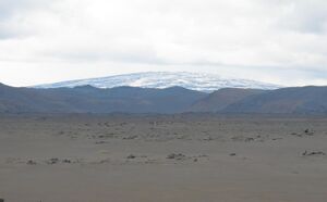
Situated in the Ódáðahraun lava field, Trölladyngja (Icelandic pronunciation: [ˈtʰrœtlaˌtiɲca] (![]() listen)) is the biggest of the Icelandic shield volcanoes, reaching a height of 1,468 metres (4,816 ft) above sea level,[1] and rising almost 600 metres above the surrounding desert and lava fields.
listen)) is the biggest of the Icelandic shield volcanoes, reaching a height of 1,468 metres (4,816 ft) above sea level,[1] and rising almost 600 metres above the surrounding desert and lava fields.
It is about 10 kilometres in diameter and its inclination is 4 to 5° in the lower slopes, but 6 to 8° at higher elevations. Its oblong crater is about 1,200 to 1,500 metres in length, 500 metres broad, and about 100 metres deep.
Most of its lava fields have flowed in a northerly direction, with one branch of it reaching the valley of Bárðardalur, a distance of roughly 100 km.
Reports of an eruption in 1961 at Trölladyngja are most likely attributed to nearby Askja Caldera, which erupted the same year.[1][2]
See also
- Volcanism of Iceland
- List of volcanic eruptions in Iceland
- List of volcanoes in Iceland
References
- ↑ 1.0 1.1 Guide to Iceland - Information about Trölladyngja, Retrieved Apr. 23, 2019.
- ↑ American Journal of Science, The eruption in Askja, 1961; a preliminary report by Sigurdur Thorarinsson and G. E. Sigvaldason, Retrieved Apr. 23, 2019.
 |


