Earth:Il-Lunzjata Valley
From HandWiki
Short description: Valley in Rabat, Gozo, Malta
| Il-Lunzjata Valley | |
|---|---|
| Wied Il-Lunzjata | |
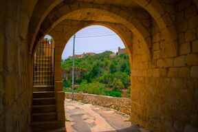
 The archway leading to the valley. | |
| Floor elevation | 197 ft (60 m) |
| Length | 0.4 km (0.25 mi) South |
| Width | 0.17 km (0.11 mi) West |
| Area | 0.1 km2 (0.039 sq mi) |
| Geography | |
| Location | Victoria, Gozo, Malta |
| Country | Script error: No such module "Compact list". |
| State | Script error: No such module "Compact list". |
| State/Province | Script error: No such module "Compact list". |
| District | Script error: No such module "Compact list". |
| Population center | Script error: No such module "Compact list". |
| Borders on | Script error: No such module "Compact list". |
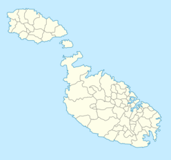
| Coordinates | [ ⚑ ] 36°2′21″N 14°13′58″E / 36.03917°N 14.23278°E |
| River | Script error: No such module "Compact list". |
| Lake | Script error: No such module "Compact list". |
Il-Lunzjata Valley (Maltese: Wied Il-Lunzjata) is an agricultural valley located southwest of Victoria, Gozo. The valley is known for its lush fields and hospitaller-era chapel.[1] Running freshwater is very common on the valley bottom during autumn and spring.[2] This supply of freshwater is commonly put to use for the farming of crops in fields within the valley[3] through a number of channels dug on the ground.[4] The valley is also home to an old fountain that makes use of the freshwater which was restored in 2007.[5] Lunzjata is also considered a Natura 2000 site.[6]
References
- ↑ "Il-Lunzjata Valley" (in en-US). https://www.visitgozo.com/where-to-go-in-gozo/sight-seeing-places-of-interest/il-lunzjata-valley/.
- ↑ "Lunzjata Valley: discover Gozo's little-known rural haven" (in en). https://www.guidememalta.com/en/lunzjata-valley-discover-gozo-s-little-known-rural-haven.
- ↑ "Il-Wied tal-Lunzjata". http://sciencefieldworkgozo.weebly.com/il-wied-tal-lunzjata.html.
- ↑ Azzopardi, George (2020) (in en). Vestiges of material culture at Il-Lunzjata valley and its immediate environs. https://www.um.edu.mt/library/oar/handle/123456789/57510.
- ↑ "Lunzjata Fountain, Kercem, Gozo | Din l-Art Ħelwa - National Trust of Malta" (in en-GB). 2011-10-06. https://dinlarthelwa.org/heritage-sites/historic-landmarks/lunzjata-fountain-kercem-gozo/.
- ↑ "Lunzjata Valley Gozo" (in en-US). 2020-11-30. https://www.barbarossaexcursions.com/lunzjata-valley-gozo/.
 |


