Earth:Radius of outermost closed isobar
| Size descriptions of tropical cyclones | |
|---|---|
| ROCI | Type |
| Less than 2 degrees latitude | Very small/midget |
| 2 to 3 degrees of latitude | Small |
| 3 to 6 degrees of latitude | Medium/Average |
| 6 to 8 degrees of latitude | Large |
| Over 8 degrees of latitude | Very large[1] |
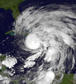
The radius of outermost closed isobar (ROCI) is one of the quantities used to determine the size of a tropical cyclone. It is determined by measuring the radii from the center of the storm to its outermost closed isobar in four quadrants, which is then averaged to come up with a scalar value. It generally delimits the outermost extent of a tropical cyclone's wind circulation.[2]
Use of this measure has objectively determined that tropical cyclones in the northwest Pacific Ocean are the largest on earth on average, with North Atlantic tropical cyclones roughly half their size.[3] Active databases of ROCI are maintained by the National Hurricane Center for systems tracked in the eastern north Pacific and north Atlantic basins.
Database
Active databases of ROCI are maintained by the National Hurricane Center for systems tracked in the eastern north Pacific and north Atlantic basins, within a database known as the Extended Best Track Database. The values are determined in real-time every six hours. The eastern north Pacific database runs from 2001 to present, while the north Atlantic database runs from 1988 to present.[4] Other than these official databases, a global once-daily dataset was compiled for a 1984 research paper, which covered global tropical cyclones between 1957 and 1977.[3] Previously, a database was created to determine ROCI values for the western north Pacific Ocean in 1972, using data from 1945 to 1968.[5] Another database with additional ROCI information is currently being modified at the Hydrometeorological Prediction Center for use in matching ongoing tropical cyclones to past systems for the purposes of finding rainfall analogs to an ongoing event,[6] which has fairly continuous data running back to 1959 for the north Atlantic ocean.[7]
Variation
Tropical cyclones tend to be smaller during the mid-summer, and largest in October in the Northern Hemisphere. As tropical cyclones initially develop, the size of their ROCI initially contracts.[8] Once tropical cyclones reach maturity, their isobaric patterns increase in size. During the mature stage, the broadening pressure pattern leads to some reduction in their maximum sustained wind, but the extent of their tropical storm and hurricane-force winds is the most extensive within the storm's life cycle.[9] An increase in size is also noted as a tropical cyclone gains latitude.[8] As tropical cyclones weaken, their ROCI values diminish. In general, the size of a tropical cyclone shows little relation to its intensity. Use of this measure has objectively determined that tropical cyclones in the northwest Pacific Ocean are the largest on earth on average, with North Atlantic tropical cyclones roughly half their size.[3]
See also
References
- ↑ Joint Typhoon Warning Center. Q: What is the average size of a tropical cyclone? United States Navy. Retrieved on 2007-07-04.
- ↑ FRÉDÉRIC MOUTON and OLA NORDBECK. Cyclone Database Manager. Retrieved on 2008-07-14.
- ↑ 3.0 3.1 3.2 Robert T. Merrill. A Comparison of Large and Small Tropical Cyclones. Retrieved on 2008-07-14.
- ↑ Mark DeMaria (2009). Atlantic Extended Best Track Database. Colorado State University. Retrieved on 2009-06-14.
- ↑ K. S. Liu and Johnny C. L. Chan. Size of Tropical Cyclones as Inferred from ERS-1 and ERS-2 Data. Retrieved on 2008-07-14.
- ↑ David M. Roth and Kyle S. Griffin (2009-06-07). Cliqr Rainfall Analog. Hydrometeorological Prediction Center. Retrieved on 2009-06-14.
- ↑ David M. Roth (2013). "CLIQR Database". Hydrometeorological Prediction Center. http://www.wpc.ncep.noaa.gov/research/roth/ebtrk_nhc_final.txt. Retrieved 2013-01-04.
- ↑ 8.0 8.1 Edward Morgan Brooks (1945). An Analysis of an Unusual Rainfall Distribution in a Hurricane. Massachusetts Institute of Technology. Retrieved on 2008-12-31.
- ↑ Gordon E. Dunn and Banner I. Miller (1960). Atlantic Hurricanes. Louisiana State University Press. p. 32.
 |


