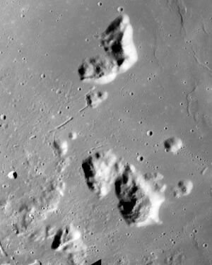
Astronomy:Montes Harbinger
From HandWiki
Revision as of 22:01, 15 November 2021 by imported>BotanyGa (over-write)
Short description: Isolated cluster of lunar mountains
| Montes Harbinger | |
|---|---|
 Apollo 15 image | |
| Highest point | |
| Listing | Lunar mountains |
| Coordinates | [ ⚑ ] 26°54′N 41°18′W / 26.9°N 41.3°W |
| Geography | |
| Location | the Moon |
Montes Harbinger is an isolated cluster of lunar mountains at the western edge of the Mare Imbrium basin.[1]
The mountains consist of four primary ridges plus several smaller hills, each forming a small rise surrounded by the lunar mare. The cluster is centered at selenographic coordinates 26.9° N, 41.3° W, within a diameter of 93 km.[2] The formation is so-named because the peaks serve as the harbingers of dawn on the crater Aristarchus,[1] located to the southwest.
The flooded crater Prinz is located to the southwest.
References
- ↑ 1.0 1.1 Rükl, Antonin; Richebé, Martine; Becker, Jean-Marc (1993). Gründ. ed (in French). Atlas de la Lune. Paris. pp. 64–65. bnf=FRBNF40580052. ISBN 978-2-700-01554-6. OCLC 301684184.
- ↑ "Montes Harbinger". Gazetteer of Planetary Nomenclature. USGS Astrogeology Research Program.
 |


