Astronomy:Promontorium Archerusia
From HandWiki
Revision as of 21:39, 19 July 2022 by imported>BotanyGa (link)
[ ⚑ ] 16°48′N 21°54′E / 16.8°N 21.9°E

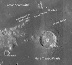
Promonontorium Archerusia is on the left of the LRO image
Promontorium Archerusia (/ˌɑːrkəˈruːʒə/; Latin for "Cape Archerusia") is a headland on the near side of the Moon. It separates the lunar mares of Mare Serenitatis and Mare Tranquilitatis. Its coordinates are [ ⚑ ] 16°48′N 21°54′E / 16.8°N 21.9°E.[1]
Promontorium Archerusia was named by Johannes Hevelius[2] and is a misspelling of Acherusia, a cape on the Black Sea near Heraclea in ancient Bithynia (now Karadeniz Ereğli in Turkey).[3][1]
References
- ↑ 1.0 1.1 "Promontorium Archerusia". Gazetteer of Planetary Nomenclature. USGS Astrogeology Research Program., accessed 15 February 2019
- ↑ Hevelius J. (1647). Selenographia sive Lunae descriptio. Gedani: Hünefeld. doi:10.3931/e-rara-238.
- ↑
 Smith, William, ed (1854). "Bithynia". Dictionary of Greek and Roman Geography. 1. London: John Murray. pp. 406.
External links
- Promontorium Archerusia at Moon Wiki
 |

