Earth:Giant's kettle

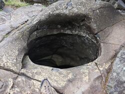
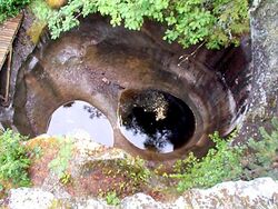
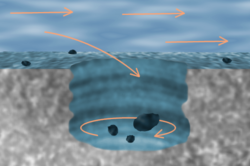
A giant's kettle, also known as either a giant's cauldron, moulin pothole, or glacial pothole, is a typically large and cylindrical pothole drilled in solid rock underlying a glacier either by water descending down a deep moulin or by gravel rotating in the bed of subglacial meltwater stream.[1]
The interiors of potholes tend to be smooth and regular, unlike a plunge pool. An example is the large pothole found in Archbald, Pennsylvania, in Archbald Pothole State Park.
Formation
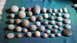
Giant's kettles are formed while a bedrock surface is covered by a glacier. Water, produced by the thawing of the ice and snow, forms streams on the surface of the glacier, which, having gathered into their courses a certain amount of morainic debris, finally flow down a crevasse as a swirling cascade or moulin. The sides of the crevasse are abraded, and a vertical shaft is formed in the ice.[2] The erosion may be continued into the bed of the glacier. After the ice departed the area, the giant's kettle formed as an empty shaft, or as a pipe filled with gravel, sand, or boulders. Such cavities and pipes afford valuable evidence as to the former extent of glaciers.[3]
Similar potholes are encountered in riverbeds and the Channeled Scablands scoured by glacial outburst floods.[4]
Notable giant's kettle

Helvete in Gausdal, Norway is a gill about 100 meters deep with giant's kettles (jettegryter) up to 20 m (66 ft) wide and 60 m (200 ft) deep.[5] The GletscherGarten of Lucerne (Switzerland ) is famous for its giant's kettles, having 32 in number, the largest being 8 m (26 ft) wide and 9 m (30 ft) deep.
They are also common in Germany (gletschertopf; glacier pot), Sweden (jättegryta), Finland (hiidenkirnu; hiisi's churn), and Moss Island in the United States .[3]
See also
- Pothole (disambiguation)
- Sinkhole
References
- ↑ Neuendorf, K.K.E., J.P. Mehl, Jr., and J.A. Jackson, eds. (2005) Glossary of Geology (5th ed.). Alexandria, Virginia, American Geological Institute. 779 pp. ISBN:0-922152-76-4
- ↑ "Archived copy". Bulletin of the Massachusetts Archaeological Society XIV (4): 112. July 1953. http://library.bridgew.edu/exhibits/BMAS/pdf/MAS-v14n04.pdf. Retrieved 12 July 2010.
- ↑ 3.0 3.1 Chisholm 1911.
- ↑ Baker, Victor (2010). Migon, Piotr. ed. Channeled Scablands: A Megaflood Landscape, in Geomorphological Landscapes of the World. Springer. pp. 21–28. ISBN 9789048130542.
- ↑ Mæhlum, Lars (15 February 2021). "Helvete (elvegjel i Gausdal)". https://snl.no/Helvete_-_elvegjel_i_Gausdal.
External links
 |


