Earth:Region of the 10 Thousanders

Lua error in Module:Location_map at line 522: Unable to find the specified location map definition: "Module:Location map/data/Baden-Württemberg" does not exist. The Region of the 10 Thousanders (German: Region der 10 Tausender) is a region in the Swabian Jura in the German state of Baden-Württemberg, the name of which alludes to the high mountain peaks in the area.
Almost all the highest mountains of the Swabian Jura (each over 1,000 m above sea level (NHN)), including their highest summit (1,015.3 m), are located in this relatively small region which only covers 20 km² around Deilingen, Wehingen and Gosheim in the southwestern Jura.
The name "Region of the 10 Thousanders" goes back to an action group that was initiated by various restaurants and municipalities of the Heuberg to promote regional tourism.
The 10 "thousanders" are – sorted by height in metres (m) above sea level (NHN):[1]
- Lemberg (1,015.3 m), near Gosheim, höchster Berg der Schwäbischen Alb ( [ ⚑ ] 48°9′2.8″N 8°44′57.4″E / 48.150778°N 8.749278°E)
- Oberhohenberg (1,010.7 m), near Schörzingen ( [ ⚑ ] 48°9′50.6″N 8°45′38.3″E / 48.164056°N 8.760639°E)
- Hochberg (1,008.5 m), near Delkhofen ( [ ⚑ ] 48°9′24.3″N 8°45′22.6″E / 48.15675°N 8.756278°E)
- Wandbühl (1,006.7 m), near Delkhofen ( [ ⚑ ] 48°10′45.6″N 8°48′32.1″E / 48.179333°N 8.808917°E)
- Rainen (1,006.1 m), near Deilingen ( [ ⚑ ] 48°10′45.4″N 8°48′32.6″E / 48.179278°N 8.809056°E)
- Montschenloch (1,004.4 m), near Delkhofen ( [ ⚑ ] 48°10′8.9″N 8°47′37.5″E / 48.169139°N 8.79375°E)
- Bol (1,002.3 m), near Deilingen ( [ ⚑ ] 48°10′15.9″N 8°48′18.3″E / 48.171083°N 8.805083°E)
- Hochwald (1,001.9 m), near Gosheim ( [ ⚑ ] 48°7′59.8″N 8°46′32.4″E / 48.133278°N 8.775667°E)
- Hummelsberg (1,001.6 m), near Denkingen ( [ ⚑ ] 48°7′4″N 8°45′49.3″E / 48.11778°N 8.763694°E)
- Kehlen (1,001.3 m), near Gosheim ( [ ⚑ ] 48°7′42.5″N 8°46′29.2″E / 48.128472°N 8.774778°E)
The following form fairly unified high mountain chains which makes them difficult to identify for those not acquainted with the area:
- Lemberg, Hochberg, Oberhohenberg
- Hochwald, Kehlen, Hummelsberg
- Wandbühl, Montschenloch, Bol, Rainen
The two other Jura peaks that are over 1,000 m, the 1,001.6 m high and very striking Plettenberg ( [ ⚑ ] 48°12′49″N 8°48′27″E / 48.21361°N 8.8075°E) near Dotternhausen and the 999.8 m high Schafberg ( [ ⚑ ] 48°13′12″N 8°50′18″E / 48.22°N 8.83833°E) near Hausen am Tann lies roughly 8 km north-northeast and are not counted within the 10 Thousanders.
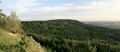
The Hummelsberg (1,001.6 m)
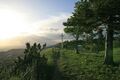
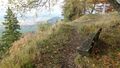
The way to the White Cross on the Kehlen (1,001.3 m)
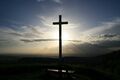
The White Cross on the Kehlen
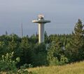
The radar tower on the Hochwald (1,001.9 m)
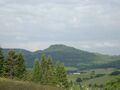
The Lemberg (1,015.3 m) – highest mountain in the Swabian Jura
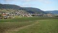
Deilingen. Behind: the Montschenloch (1,004. m) with its transmission tower
On the Oberhohenberg (1,010.7 m) – second highest mountain of the Swabian Jura


References
External links
- Region der zehn Tausender (Heuberg Aktiv e. V.), at heuberg.de
- Die Region der 10 Tausender – overview map (Homepage Gymnasium Gosheim-Wehingen)
 |  |

