Astronomy:Explorer 27
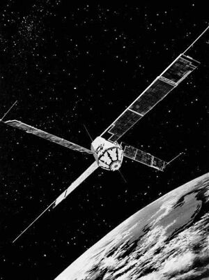
 Depiction of Explorer 27 in orbit | |
| Operator | NASA |
|---|---|
| Mission duration | ~8 Years |
| Spacecraft properties | |
| Manufacturer | GSFC |
| Power | Solar Panels |
| Start of mission | |
| Launch date | 29 April 1965 |
| Rocket | Scout |
| Launch site | Wallops Flight Facility |
| End of mission | |
| Last contact | 20 July 1973 |
| Orbital parameters | |
| Reference system | Geocentric |
| Regime | LEO |
| Eccentricity | 0.02618 |
| Perigee altitude | 932.3 km (579.3 mi) |
| Apogee altitude | 1,311.3 km (814.8 mi) |
| Inclination | 41.1° |
| Period | 107.6 minutes |
| Instruments | |
| Radio Beacon, Langmuir probe | |
Explorers | |
Explorer 27 (or BE-C or Beacon Explorer-C or Beacon-C) was a satellite, launched in 1965, designed to conduct scientific research in the ionosphere.[1] It was powered by 4 solar panels. One goal or the mission was to study in detail the shape of the Earth by way of investigating variations in its gravitational field.[2] It was the third and last of the Beacons in the Explorers program. The satellite was shut off in 1973 so that its transmission band could be used by higher-priority spacecraft.
Spacecraft design

Built at the Applied Physics Laboratory [4] under the direction of Goddard Space Flight Center (Project Manager F. T. Martin),[3] Explorer 27 began as S-66, the last of the five satellites in NASA's first stage of ionospheric exploration, and the first of five NASA geodetic satellites.[5]: 346 Its primary mission was "to conduct ionospheric measurements on a worldwide basis. The program will determine the total electron content of a vertical cross-section of the ionosphere located between the satellite and the earth. Accomplishing this objective will aid in establishing the behavior pattern of the ionosphere as a function of latitude, time of day, season, and solar cycle."[3]
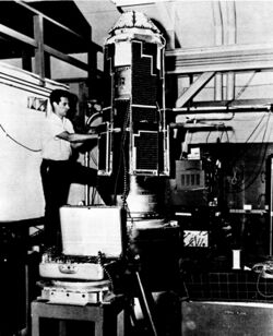
Weighing 130 pounds (59 kg), the satellite was an octagonal spacecraft with a honeycomb nylon and Fiberglas hull, 18 inches (46 cm) in diameter, 12 inches (30 cm) high, with four solar panels 10 inches (25 cm) wide and 66 inches (168 cm) long.[3]
A three-axis magnetometer and sun sensors provided information on the satellite attitude and spin rate.[6] There was no tape recorder aboard so that satellite could be received only when the satellite was within range of a ground telemetry station. Continuous Doppler transmitters operated at 162 MHz and 324 MHz to permit precise tracking by Transit tracking stations for navigation and geodetic studies.[7] Four other transmitters operated on 20, 40, 41, and 360 MHz to measure ionospheric density. S-66's last experiment was an Electron Density Experiment designed for measuring charged particles in the immediate vicinity of the satellite.[3]
S-66 mounted 360 one-inch "cube corner" reflectors made of fused silica[3] so that the satellite could be tracked via lasers beamed from mobile stations at Goddard's Wallops Island facility[5]: 346 [8] and other facilities.
The first S-66 was scheduled for launch in late 1963. However, due to problems with the Scout X-4,[3] the flight was rescheduled for the following year on a Delta booster, from Cape Canaveral's Launch Complex 17A.[9] On March 19, 1964, the first attempt to this S-66 ended in failure when the third stage of its Delta rocket burned just 22 seconds instead of the programmed 40. This was only the second time the Delta booster had failed, and the incident followed 22 prior successes.[5]: 109
A second S-66 was launched, this time successfully, via a Scout X-4 rocket at 03:01 UT, October 9, 1964, from the PALC-D launch facility at Vandenberg Air Force Base . Once in space, it became known as Explorer 22.[9]
Mission
Explorer 22's as-yet unnamed backup was scheduled for launch in March/April 1965 to extend the geodetic experiments of its predecessor.[10] Upon the backup's launch on April 29, 1965 at 14:17 UT via Scout X-4 from Wallops Island, this third S-66 satellite was designated Explorer 27.[9]
Results
Explorer 27 was turned off on 20 July 1973 because it was interfering with other, more important satellites. Tracking of the satellite via its passive laser reflectors continued at least into the 21st Century.[11]
See also
References
- ↑ "BE-C". https://nssdc.gsfc.nasa.gov/nmc/spacecraft/display.action?id=1965-032A.
- ↑ "Explorer Series of Spacecraft". NASA. https://history.nasa.gov/explorer.html.
- ↑ 3.0 3.1 3.2 3.3 3.4 3.5 3.6 "Environmental test program of the beacon explorer spacecraft". NASA Goddard Space Flight Center; Greenbelt, MD, United States. https://ntrs.nasa.gov/archive/nasa/casi.ntrs.nasa.gov/19650005987.pdf.
- ↑ Brian Harvey (24 November 2017). Discovering the Cosmos with Small Spacecraft: The American Explorer Program. Springer. pp. 91–. ISBN 978-3-319-68140-5. https://books.google.com/books?id=PGRADwAAQBAJ&pg=PA91.
- ↑ 5.0 5.1 5.2 "Astronautics and Aeronautics, 1964". NASA, Scientific and Technical Division. https://ntrs.nasa.gov/archive/nasa/casi.ntrs.nasa.gov/19650018040.pdf.
- ↑ Ludwig Combrinck, 2010. Sciences of Geodesy (Cap. 9). Springer-Verlag. Retrieved June 9, 2018.
- ↑ "BE-C". https://nssdc.gsfc.nasa.gov/nmc/spacecraft/display.action?id=1964-064A.
 This article incorporates text from this source, which is in the public domain.
- ↑ "Goddard laser systems and their accuracies". Philosophical Transactions of the Royal Society (London: McGraw Hill Publishing Company): 443-444. 1977. https://royalsocietypublishing.org/doi/pdf/10.1098/rsta.1977.0017. Retrieved October 21, 2019.
- ↑ 9.0 9.1 9.2 McDowell, Jonathan. "Launch Log". Jonathon's Space Report. http://planet4589.org/space/log/launchlog.txt.
- ↑ "Beacon Explorer Surveys Ionosphere". Aviation Week and Space Technology (New York: McGraw Hill Publishing Company): 35. October 19, 1964. http://archive.aviationweek.com/issue/19641019#!&pid=34. Retrieved October 21, 2019.
- ↑ "Beacon-C". https://ilrs.cddis.eosdis.nasa.gov/missions/satellite_missions/current_missions/beac_general.html.
External links

