Astronomy:Kästner (crater)
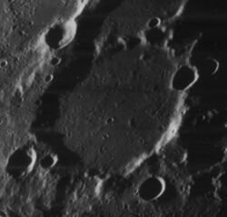
 Oblique Lunar Orbiter 4 image | |
| Diameter | 116.07 km |
|---|---|
| Depth | 3.4 km[1] |
| Colongitude | 283° at sunrise |


Kästner is a lunar impact crater that is located near the eastern limb of the Moon, to the southwest of the Mare Smythii. Just to the northwest of Kästner is the walled plain Gilbert. To the south is the prominent crater Ansgarius, and to the southwest lies La Pérouse.
This formation belongs to the category termed a walled plain. It has a worn, irregular outer wall that is overlaid by several small craters and there is a small break along the north-northeast. Along the northeastern rim is Kästner B, and to the southwest is the small Kästner E. A shallow, unnamed crater is attached to the southern rim. The interior floor is relatively level and featureless, with only a few small craters and minor ridges.
The crater's name was approved by the IAU in 1961.[2]
Satellite craters
By convention these features are identified on lunar maps by placing the letter on the side of the crater midpoint that is closest to Kästner.
| Kästner | Latitude | Longitude | Diameter |
|---|---|---|---|
| A | 4.5° S | 77.3° E | 25 km |
| B | 6.3° S | 80.7° E | 20 km |
| C | 8.0° S | 76.9° E | 19 km |
| E | 8.1° S | 77.6° E | 10 km |
| G | 4.2° S | 79.0° E | 72 km |
| R | 6.9° S | 82.3° E | 17 km |
| S | 8.0° S | 83.2° E | 30 km |
The following craters have been renamed by the IAU.
- Kästner F — See Black.
Kästner B, R, and S are called Defoe, Shekhov, and Cellini on some older maps,[3] but these names were not approved by the IAU.
References
- ↑ LTO-81A3 Kästner, Lunar Topographic Orthophotomap (LTO) Series
- ↑ Kästner, Gazetteer of Planetary Nomenclature, International Astronomical Union (IAU) Working Group for Planetary System Nomenclature (WGPSN)
- ↑ LTO-81B4 Kiess, Lunar Topographic Orthophotomap (LTO) Series
- Andersson, L. E.; Whitaker, E. A. (1982). NASA Catalogue of Lunar Nomenclature. NASA RP-1097.
- Blue, Jennifer (July 25, 2007). "Gazetteer of Planetary Nomenclature". USGS. http://planetarynames.wr.usgs.gov/.
- Bussey, B.; Spudis, P. (2004). The Clementine Atlas of the Moon. New York: Cambridge University Press. ISBN 978-0-521-81528-4.
- Cocks, Elijah E.; Cocks, Josiah C. (1995). Who's Who on the Moon: A Biographical Dictionary of Lunar Nomenclature. Tudor Publishers. ISBN 978-0-936389-27-1. https://archive.org/details/isbn_9780936389271.
- McDowell, Jonathan (July 15, 2007). "Lunar Nomenclature". Jonathan's Space Report. http://host.planet4589.org/astro/lunar/.
- Menzel, D. H.; Minnaert, M.; Levin, B.; Dollfus, A.; Bell, B. (1971). "Report on Lunar Nomenclature by the Working Group of Commission 17 of the IAU". Space Science Reviews 12 (2): 136–186. doi:10.1007/BF00171763. Bibcode: 1971SSRv...12..136M.
- Moore, Patrick (2001). On the Moon. Sterling Publishing Co. ISBN 978-0-304-35469-6. https://archive.org/details/patrickmooreonmo00patr.
- Price, Fred W. (1988). The Moon Observer's Handbook. Cambridge University Press. ISBN 978-0-521-33500-3.
- Rükl, Antonín (1990). Atlas of the Moon. Kalmbach Books. ISBN 978-0-913135-17-4.
- Webb, Rev. T. W. (1962). Celestial Objects for Common Telescopes (6th revised ed.). Dover. ISBN 978-0-486-20917-3. https://archive.org/details/celestialobjects00webb.
- Whitaker, Ewen A. (1999). Mapping and Naming the Moon. Cambridge University Press. ISBN 978-0-521-62248-6.
- Wlasuk, Peter T. (2000). Observing the Moon. Springer. ISBN 978-1-85233-193-1.
 |

