Astronomy:O'Day (crater)
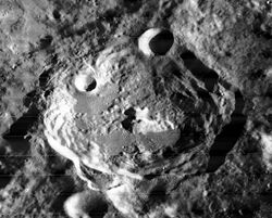
 Lunar Orbiter 2 image | |
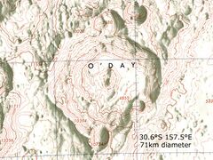
| Diameter | 71 km |
|---|---|
| Depth | Unknown |
| Colongitude | 203° at sunrise |

O'Day is a prominent lunar impact crater that is located on the far side of the Moon. It intrudes into the northwestern edge of Mare Ingenii, and the rim is lower on that side. To the northwest is the crater pair of Holetschek and Sierpinski. Southwest of O'Day lies the crater Seidel. It is named in honour of the American physicist Marcus O'Day.
The crater rim of O'Day remains sharp-edged, and the inner wall is terraced, especially in the northwestern half away from the mare. A small crater lies across the southern rim, and a tiny craterlet is located in the low inner rim between the crater and the mare. The floor is rough and irregular, with a double-peak at the midpoint.
Due to its prominent rays, O'Day is mapped as part of the Copernican System.[1]
Satellite craters
By convention these features are identified on lunar maps by placing the letter on the side of the crater midpoint that is closest to O'Day.
| O'Day | Latitude | Longitude | Diameter |
|---|---|---|---|
| B | 29.1° S | 158.0° E | 16 km |
| M | 31.7° S | 157.1° E | 16 km |
| T | 30.4° S | 154.4° E | 24 km |
External links
- Lunar Map 103, showing O'Day and surroundings (Regional maps at the Lunar and Planetary Institute.)
References
- ↑ The geologic history of the Moon, 1987, Wilhelms, Don E.; with sections by McCauley, John F.; Trask, Newell J. USGS Professional Paper: 1348. Plate 11: Copernican System (online)
- Andersson, L. E.; Whitaker, E. A. (1982). NASA Catalogue of Lunar Nomenclature. NASA RP-1097.
- Blue, Jennifer (July 25, 2007). "Gazetteer of Planetary Nomenclature". USGS. http://planetarynames.wr.usgs.gov/.
- Bussey, B.; Spudis, P. (2004). The Clementine Atlas of the Moon. New York: Cambridge University Press. ISBN 978-0-521-81528-4.
- Cocks, Elijah E.; Cocks, Josiah C. (1995). Who's Who on the Moon: A Biographical Dictionary of Lunar Nomenclature. Tudor Publishers. ISBN 978-0-936389-27-1. https://archive.org/details/isbn_9780936389271.
- McDowell, Jonathan (July 15, 2007). "Lunar Nomenclature". Jonathan's Space Report. http://host.planet4589.org/astro/lunar/.
- Menzel, D. H.; Minnaert, M.; Levin, B.; Dollfus, A.; Bell, B. (1971). "Report on Lunar Nomenclature by the Working Group of Commission 17 of the IAU". Space Science Reviews 12 (2): 136–186. doi:10.1007/BF00171763. Bibcode: 1971SSRv...12..136M.
- Moore, Patrick (2001). On the Moon. Sterling Publishing Co.. ISBN 978-0-304-35469-6. https://archive.org/details/patrickmooreonmo00patr.
- Price, Fred W. (1988). The Moon Observer's Handbook. Cambridge University Press. ISBN 978-0-521-33500-3.
- Rükl, Antonín (1990). Atlas of the Moon. Kalmbach Books. ISBN 978-0-913135-17-4.
- Webb, Rev. T. W. (1962). Celestial Objects for Common Telescopes (6th revised ed.). Dover. ISBN 978-0-486-20917-3. https://archive.org/details/celestialobjects00webb.
- Whitaker, Ewen A. (1999). Mapping and Naming the Moon. Cambridge University Press. ISBN 978-0-521-62248-6.
- Wlasuk, Peter T. (2000). Observing the Moon. Springer. ISBN 978-1-85233-193-1.
 |


