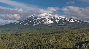
Earth:Burney Mountain
From HandWiki
| Burney Mountain | |
|---|---|
 Burney Mountain in March 2017 | |
| Highest point | |
| Elevation | 2,397 m (7,864 ft) [1] |
| Prominence | 873 m (2,864 ft) [2] |
| Coordinates | [ ⚑ ] : 40°48′23.59″N 121°37′39.98″W / 40.8065528°N 121.6277722°W |
| Geography | |
Lua error in Module:Location_map at line 522: Unable to find the specified location map definition: "Module:Location map/data/California" does not exist.
| |
| Location | Shasta County, California , United States |
| Parent range | Cascade Range |
| Topo map | USGS Burney Mountain West |
Burney Mountain is a lava dome complex located in the Cascade Range of eastern Shasta County, California, next to the slightly larger Crater Peak and slightly smaller Magee Peak. It stands at 2,397 m (7,854 ft)[1] and is around 8.9 km (5.5 mi) south-southeast of Burney, California.
Burney Mountain last erupted about 230,000 years ago during the Pleistocene epoch. It is composed of two craters, which open to the east.[3][4][5] Burney Mountain is the largest Quaternary dome in the Cascade Volcanic Arc, containing a volume of about 9 km3 (2.2 cu mi).[6]
The eastern side of the mountain was burned in the Eiler Fire in 2014, ultimately destroying 21 structures and injuring 11 people, mostly in Hat Creek.[7]
References
- ↑ Jump up to: 1.0 1.1 "Burney Mountain". United States Geological Survey. https://geonames.usgs.gov/apex/f?p=gnispq:3:::NO::P3_FID:257713.
- ↑ "Burney Mountain, California". http://www.peakbagger.com/peak.aspx?pid=2497.
- ↑ "Burney Mountain". https://volcano.si.edu/volcano.cfm?vn=323807. Retrieved 30 January 2019.
- ↑ Wood, Charles A.; Kienle, Jurgen (November 27, 1992). Volcanoes of North America: United States and Canada (illustrated, reprint ed.). Cambridge University Press. p. 222. ISBN 9780521438117. https://books.google.com/books?id=eyDRib-FJh4C. Retrieved 30 January 2019.
- ↑ Sulpizio, Roberto; Costa, Antonio; Wadge, Geoffrey (October 10, 2017). Stress Field Control of Eruption Dynamics. Frontiers Media. pp. 115–127. ISBN 2889452778. https://books.google.com/books?id=zgQ5DwAAQBAJ. Retrieved 30 January 2019.
- ↑ Hildreth, Wes (2007). Quaternary Magmatism in the Cascades—Geologic Perspectives. United States Geological Survey. p. 45. ISBN 978-1-4113-1945-5. https://pubs.usgs.gov/pp/pp1744/.
- ↑ "Eiler Fire". July 31, 2014. https://www.fire.ca.gov/incidents/2014/7/31/eiler-fire.

